geocat.ch
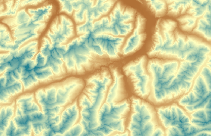
The digital height model of Switzerland with a 200m grid
The digital height model DHM25 / 200 is a data set representing the three-dimensional form of the earth's surface. It is a height matrix with a 200-m grid. It has been resampled from the DHM25 matrix model, which has a 25-m grid. he DHM25 represents the topography of the earth's surface without vegetation or built up areas. Lakes are represented by their surface. DHM25 / 200 can be freely downloaded.
Simple
- Alternate title
-
DHM25 / 200
- Date (Publication)
- 2010-01-01
- Identifier
- ch.swisstopo.digitales-hoehenmodell_25
- Status
- Completed
Point of contact
- Spatial representation type
- Grid
Spatial resolution
- Spatial resolution
- 200 m
- Topic category
-
- C Elevation
Extent
Extent
- Description
-
DHM25
- Geographic identifier
- DHM25
))

- Maintenance and update frequency
- Not planned
- Maintenance note
-
The status of the DHM25 corresponds to that of the initial capture and digitization of the elements for the basis model except for glacial regions, which were updated in winter 2000/2001.
- geocat.ch
-
-
geodata
-
isophysis
-
GIS (Geographic Information System)
-
terrain representation
-
contour line
-
DEM (digital elevation model)
-
spot height
-
topography
-
digital terrain model DTM
-
opendata.swiss
-
3D visualisation
-
hillshade
-
- GEMET - INSPIRE themes, version 1.0
-
-
Elevation
-
- GEMET
-
-
relief (land)
-
- geocat.ch
-
-
FSDI Federal Spatial Data Infrastructure
-
Resource constraints
- Other constraints
-
NonCommercialAllowed-CommercialAllowed-ReferenceRequired
Associated resource
- Association Type
- Reference to a master resource of which this one is a part
- Metadata Reference
- Language
- Deutsch
- Character encoding
- UTF8
- Basic Geodata
- true
- Basic Geodata ID
-
41.3
- Basic Geodata Legal Level
- Federal
- Distribution format
-
-
ESRI Arcinfo ASCII GRID (ASC)
-
GRID ASCII (XYZ)
-
AutoCAD DXF (DXF)
-
Digital transfer options
Digital transfer options
- OnLine resource
-
Shop
Digital transfer options
- OnLine resource
-
MNT25 / 200m
- Statement
-
Interpolation based on the elevation information of the National map 1:25'000, of the National map 1:50'000 for the extended perimeter.
- Hierarchy level
- Dataset
- Reference system identifier
- EPSG:21781
- Reference system identifier
- EPSG:5728
Metadata
- Metadata identifier
- 7eeb5314-f988-4e70-be61-07bfafc10439
- Language
- Deutsch
- Character encoding
- UTF8
- Language
- Français
- Character encoding
- UTF8
- Language
- Italiano
- Character encoding
- UTF8
- Language
- English
- Character encoding
- UTF8
Point of contact
Type of resource
- Resource scope
- Dataset
- Metadata linkage
-
https://www.geocat.ch/geonetwork/srv/api/records/7eeb5314-f988-4e70-be61-07bfafc10439
- Date info (Creation)
- 2016-01-05T11:43:47Z
- Date info (Revision)
- 2026-04-13T09:16:29.067216Z
Metadata standard
- Title
-
eCH-0271