geocat.ch
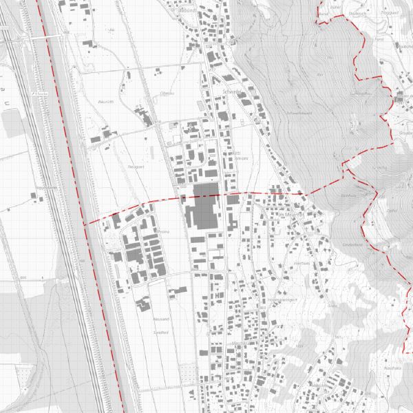
Territorial borders Liechtenstein
National borders and municipal borders of Liechtenstein. The national border data is available on the basis of the international treaties with Switzerland and Austria. The municipal boundaries are based on the official cadastral survey data
Simple
- Alternate title
-
National and municipal boundaries Principality of Liechtenstein
- Date (Publication)
- 2013-11-12
- Identifier
- https://metadata.geo.llv.li/7dd0cb7f-43f9-4db4-b83f-66b43a47f943
- Purpose
-
Cadastre, territory
- Status
- Completed
Publisher
- Hours of service
-
8:00-11:30 und 13:30-17:00
- Spatial representation type
- Vector
Spatial resolution
Equivalent scale
- Denominator
- 500
- Topic category
-
- D Boundaries
Extent
Extent
- Description
-
Liechtenstein
))

- Maintenance and update frequency
- As needed
- GEMET
-
-
vector
-
- GEMET - INSPIRE themes, version 1.0
-
-
Administrative units
-
- geocat.ch
-
-
OpenData
-
INSPIRE
-
- Räumlicher Anwendungsbereich
-
-
National
-
Resource constraints
- Use limitation
-
no conditions apply
- Access constraints
- Other restrictions
- Use constraints
- Other restrictions
- Other constraints
- No limitations to public access
Resource constraints
- Access constraints
- Other restrictions
- Use constraints
- Other restrictions
- Other constraints
- No conditions to access and use
- Other constraints
- Opendata BY: Open use. Must provide the source.
- Language
- Deutsch
- Character encoding
- UTF8
- Distribution format
-
-
INTERLIS 1 (ITF)
-
AutoCAD DXF (DXF)
-
ESRI Shapefile (SHP)
-
Point of contact
- Hours of service
-
8:00-11:30 und 13:30-17:00
Digital transfer options
- OnLine resource
-
Geodatenportal der Liechtensteinischen Landesverwaltung
Geodatenportal
Digital transfer options
- OnLine resource
-
llv.abi.av.gdegrenze
OGC WMS Service der Liechtensteinen Landesverwaltung
Digital transfer options
- OnLine resource
-
Zip Download über das Geodatenportal
Zip Download über das Geodatenportal
- Hierarchy level
- Dataset
- Other
-
Alle Ebenen
Report
Result
- Title
-
COMMISSION REGULATION (EU) No 1089/2010 of 23 November 2010 implementing Directive 2007/2/EC of the European Parliament and of the Council as regards interoperability of spatial data sets and services
- Date (Publication)
- 2010-12-08
- Explanation
-
nicht geprüft
- Pass
- false
- Statement
-
Land surveying and official surveying
- Hierarchy level
- Dataset
- Other
-
Alle Ebenen
- Topology level
- Full planar graph
- Geometric object type
- Surface
- Geometric object count
- 20
- Topology level
- Topology 1D
- Geometric object type
- Curve
- Geometric object count
- 2
- Reference system identifier
- http://www.opengis.net/def/crs/EPSG/0/21782
- Reference system identifier
- http://www.opengis.net/def/crs/EPSG/0/4258
- Reference system identifier
- http://www.opengis.net/def/crs/EPSG/0/4326
- Maintenance and update frequency
- As needed
Metadata
- Metadata identifier
- 7dd0cb7f-43f9-4db4-b83f-66b43a47f943
- Language
- Deutsch
- Character encoding
- UTF8
- Language
- Français
- Character encoding
- UTF8
- Language
- Italiano
- Character encoding
- UTF8
- Language
- English
- Character encoding
- UTF8
Point of contact
- Hours of service
-
8:00-11:30 und 13:30-17:00
Type of resource
- Resource scope
- Dataset
- Metadata linkage
-
https://www.geocat.ch/geonetwork/srv/api/records/7dd0cb7f-43f9-4db4-b83f-66b43a47f943
- Date info (Creation)
- 2015-03-18T09:17:18Z
- Date info (Revision)
- 2026-04-13T09:32:25.58839Z
Metadata standard
- Title
-
eCH-0271