geocat.ch
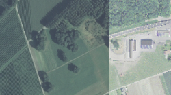
Orthophotos (région Martigny-Lac Léman)
Orthophotos Martigny-Léman fournies par la société Axit-Georiviera à Vevey
Simple
- Alternate title
-
Orthophotos Martigny-Léman
- Date (Creation)
- 1995-01-01
- Identifier
- 164
- Purpose
-
Diverses études du Plan Directeur Cantonal et de l'Espace Mont-Blanc
- Status
- Historical archive
Custodian
- Spatial representation type
- Grid
Spatial resolution
- Spatial resolution
- 70 m
- Topic category
-
- A Imagery base maps earth cover
Extent
Extent
- Description
-
Région Martigny Léman
- Geographic identifier
- VS_Martigny_Leman
))

- Maintenance and update frequency
- Not planned
Resource format
- Title
-
ESRI Enterprise Geodatabase
- Date
- GEMET
-
-
land management and planning
-
- geocat.ch
-
-
official geodata
-
orthophoto
-
Resource constraints
- Use limitation
-
Aucune
Resource constraints
- Access constraints
- Other restrictions
- Other constraints
-
Géodonnées accessibles au public (niveau A selon l'OGéo)
- Other constraints
-
Les conditions générales d'utilisation des géodonnées du Canton du Valais font foi ( https://www.vs.ch/fr/web/guest/information-legale).
- Language
- Français
- Character encoding
- UTF8
- Environment description
-
S:\Géodonnées VS\A3 Images\Martigny-Lac Léman 1995.lyr S:\Géodonnées VS\A3 Images\Martigny-Lac Léman 1995 Index.lyr
- Subtopic Category
- A3 Aerial and Satellite Imagery
- Basic Geodata
- false
- Basic Geodata Legal Level
- Cantonal
- Basic Geodata Type
- Reference Geodata
- Distribution format
-
-
GeoTIFF (GEOTIFF)
-
Cloud Optimized GeoTIFF (TIFF / TIF)
-
Distributor
- Statement
-
Axit-Georiviera, Vevey
- Hierarchy level
- Dataset
- Description
-
Axit-Georiviera, Vevey
- Reference system identifier
- EPSG:2056/CH1903+_MN95
Metadata
- Metadata identifier
- 7984e932-808b-4674-97ad-45e561509497
- Language
- Français
- Character encoding
- UTF8
- Language
- Deutsch
- Character encoding
- UTF8
- Language
- Italiano
- Character encoding
- UTF8
- Language
- English
- Character encoding
- UTF8
- Language
- Rumantsch
- Character encoding
- UTF8
Distributor
Type of resource
- Resource scope
- Dataset
- Metadata linkage
-
https://www.geocat.ch/geonetwork/srv/api/records/7984e932-808b-4674-97ad-45e561509497
- Date info (Creation)
- 2016-10-26T14:41:44Z
- Date info (Revision)
- 2026-05-18T12:02:44.636304Z
Metadata standard
- Title
-
eCH-0271