geocat.ch
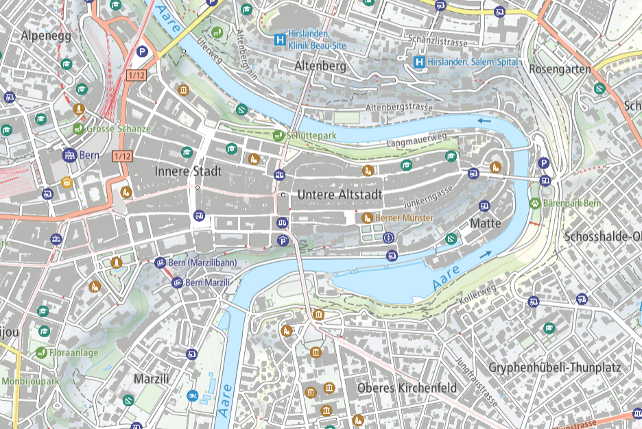
Base Map (Vector Tile Style)
The BaseMap is a dynamic web-map built on vectortile technology, designed specifically for optimal use on mobile devices. All map elements are displayed in vector format, including terrain representations. The BaseMap includes a wide range of features, such as points-of-interest (POI) covering various topics. It combines official data (including the topographic landscape model, digital elevation model, digital cartographic model, public transport stops and the official road directory), as well as third-party data. The map’s content varies based on the zoom level displayed. The vector representation adheres to the Maplibre style specification. The data basis consists of vector tiles (Base Vector Tileset and Relief Vector Tileset).
Simple
- Alternate title
-
Base Map
- Date (Creation)
- 2023-07-01
- Date (Revision)
- 2024-03-01
- Identifier
- ch.swisstopo.basemap.vt
- Status
- On going
Point of contact
Owner
- Spatial representation type
- Vector
Spatial resolution
Equivalent scale
- Denominator
- 5000
Spatial resolution
Equivalent scale
- Denominator
- 1000000
- Topic category
-
- A Imagery base maps earth cover
Extent
Extent
- Description
-
National map 1:1'000'000
- Geographic identifier
- NM1000
))

- Maintenance and update frequency
- As needed
- geocat.ch
-
-
official geodata
-
FSDI Federal Spatial Data Infrastructure
-
base map
-
opendata.swiss
-
Resource constraints
- Use limitation
-
The terms of use for free geodata and geoservices (OGD) from swisstopo and the general terms of use and operating regulations of the Federal Spatial Data Infrastructure FSDI apply.
For digital or analogue representations and publications, the following source reference must be included: © swisstopo, © FDFA, © FOEN, © FOCP, © SAC, © Naturefriends Switzerland, © opentransportdata.swiss, © pharmaSuisse
For data defined as open data by third-party providers, their terms of use also apply.
- Use constraints
- Other restrictions
- Other constraints
- Terms of use for free geodata and geoservices (OGD) from swisstopo
- Other constraints
- General Terms of Use and Operating Conditions of the Federal Spatial Data Infrastructure FSDI
- Other constraints
- Terms of use opendata.swiss
Associated resource
- Title
-
National survey
- Association Type
- Reference to a master resource of which this one is a part
- Language
- English
- Character encoding
- UTF8
- Supplemental Information
-
For administrative units of the Swiss central federal administration, following specification in Annex 1 of the Government and Administration Organisation Ordinance (Annex 1 RVOV, SR 172.010.1), the Base Map is also available in its global version (Base Map World).
- Subtopic Category
- A1 Base Maps, Landscape Models
- Basic Geodata
- true
- Basic Geodata ID
-
42.18
- Basic Geodata Legal Level
- Federal
- Basic Geodata Type
- Reference Geodata
- Distribution format
-
-
JavaScript Object Notation (JSON)
-
Digital transfer options
Digital transfer options
Digital transfer options
Digital transfer options
- OnLine resource
-
Download Vector Tile Style
- Reference system identifier
- EPSG:3857
Metadata
- Metadata identifier
- 77ccb73b-2867-4036-92c4-0a96bda8f45b
- Language
- Deutsch
- Character encoding
- UTF8
- Language
- Français
- Character encoding
- UTF8
- Language
- Italiano
- Character encoding
- UTF8
- Language
- English
- Character encoding
- UTF8
- Language
- Rumantsch
- Character encoding
- UTF8
Point of contact
Type of resource
- Resource scope
- Dataset
- Metadata linkage
-
https://www.geocat.ch/geonetwork/srv/api/records/77ccb73b-2867-4036-92c4-0a96bda8f45b
- Date info (Creation)
- 2023-06-27T08:13:50.786Z
- Date info (Revision)
- 2026-04-13T09:25:24.765494Z
Metadata standard
- Title
-
GM03 2+