geocat.ch
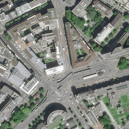
Satellitenbild Basel-Stadt 2022 (30cm)
Entzerrte und georeferenzierte digitale Satellitenbilder in TrueColor, die teilweise Wolken und Lichtreflexe aufweisen können. Im Bereich von Kunst- und Hochbauten können geometrische Abweichungen zu den Grundlagedaten der amtlichen Vermessung vorkommen. Sensor/Satellit: Pléiades Neo; Aufnahmedatum: 11. Mai 2022; Betreiber/Distributionsfirma: CNES 2022, Distribution Airbus DS
Simple
- Date (Creation)
- 2022-05-11T00:00:00
- Status
- Completed
Owner
- Spatial representation type
- Grid
Spatial resolution
- Spatial resolution
- 0.3 m
- Topic category
-
- A Imagery base maps earth cover
Extent
Extent
- Description
-
Canton of Basel-Stadt (BS)
))

- Maintenance and update frequency
- Not planned
- GEMET
-
-
aerial photograph
-
- GEMET
-
-
satellite image
-
- geocat.ch
-
-
orthophoto
-
Resource constraints
- Other constraints
-
Die Geodaten sind öffentlich zugänglich. (Zugangsberechtigungsstufe [A] = öffentlich)
- Other constraints
-
Es gelten die Nutzungsbedingungen für Geodaten des Kantons Basel-Stadt. ( http://www.geo.bs.ch/agb)
Associated resource
- Association Type
- Resource is a description of associated resource
- Metadata Reference
Associated resource
- Title
-
Satellitenbilder
- Association Type
- Reference to a master resource of which this one is a part
- Language
- Deutsch
- Character encoding
- UTF8
- Subtopic Category
- A3 Aerial and Satellite Imagery
- Distribution format
-
-
INTERLIS 1 (ITF)
-
Distributor
- Hours of service
-
Mo - Do: 8:00 bis 12:00, 13:30 bis 16:30, Fr: 8:00 bis 12:00, 13:30 bis 16:00
Digital transfer options
- OnLine resource
-
MapBS
Öffentliches Auskunftssystem des Kantons Basel-Stadt
- Reference system identifier
- CH1903+ / LV95/EPSG: 2056
Metadata
- Metadata identifier
- 73c66d1b-546f-4bed-9d12-d432163fd3a7
- Language
- Deutsch
- Character encoding
- UTF8
- Language
- Français
- Character encoding
- UTF8
- Language
- Italiano
- Character encoding
- UTF8
- Language
- English
- Character encoding
- UTF8
Custodian
Type of resource
- Resource scope
- Dataset
- Metadata linkage
-
https://www.geocat.ch/geonetwork/srv/api/records/73c66d1b-546f-4bed-9d12-d432163fd3a7
- Date info (Creation)
- 2022-08-31T09:56:33Z
- Date info (Revision)
- 2026-04-13T09:41:00.968851Z
Metadata standard
- Title
-
eCH-0271