geocat.ch
Luftbildstreifen swisstopo
Bandes d'images aériennes swisstopo
Strisce aeree swisstopo
Image strips swisstopo
Strivlas da fotografias ord l'aria swisstopo
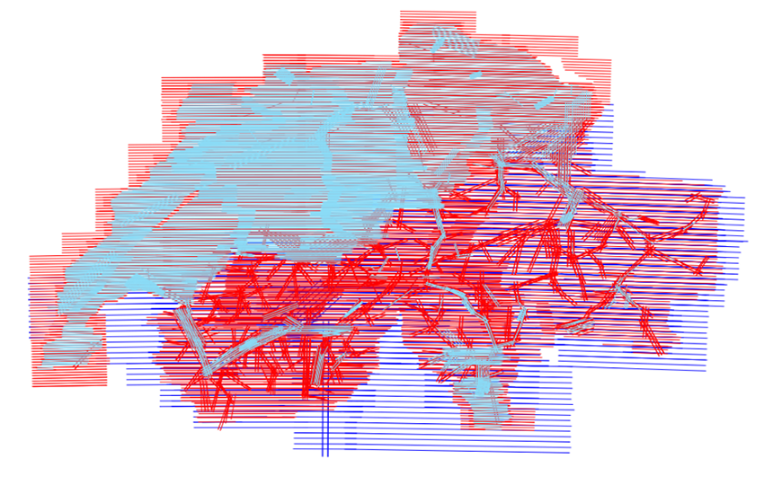
swisstopo erfasst die gesamte Fläche der Schweiz im Rahmen der Nachführung der Landeskarte und zur Produktion des Orthofotomosaiks SWISSIMAGE in einem Dreijahreszyklus mit Luftbildstreifen. Seit 2008 werden dazu digitale Luftbildkameras vom Typ ADS eingesetzt. Dabei erfolgt die Bilderfassung im Gegensatz zu Einzelbildkameras streifenweise. Sämtliche Bildstreifen weisen die Kanäle Pan, Infrarot, Rot, Grün und Blau auf. Die Luftbildstreifen sind in Form ihrer Lage, des jeweiligen abgedeckten Bodensegments (Footprint) sowie mit Metainformationen dargestellt. Die Luftbildstreifen können als digitale Datei inkl. Orientierungselementen bestellt werden.
Pour la mise à jour de la carte nationale et la production de la mosaïque d'orthophotos SWISSIMAGE, swisstopo couvre toute la surface de la Suisse avec des bandes d’images aériennes dans un cycle de 3 ans. Depuis 2008, des caméras numériques de type ADS sont utilisées. Ce système réalise des prises de vue par bande, contrairement aux caméras à images individuelles. Toutes les bandes d’images aériennes comportent les canaux pan, infrarouge, rouge, vert et bleu. Les bandes d’images sont représentées par leur position, par la zone couverte (footprint) ainsi que par des métadonnées. Les bandes d’images aériennes peuvent être commandées sous forme de fichiers numériques incluant les éléments d’orientation.
Per l’aggiornamento delle carte nazionali e la produzione del mosaico di ortofoto SWISSIMAGE, swisstopo rileva tutta la superficie della Svizzera con delle strisce d’immagini aeree in un ciclo di 3 anni. Dal 2008 swisstopo utilizza delle fotocamere digitali del tipo ADS. Il rilevamento con questo sistema avviene a strisce, contrariamente alle fotocamere ad immagini individuali. Tutte le strisce d’immagini aeree presentano i canali pan, infrarosso, rosso, verde e blu. Le strisce d’immagini sono rappresentate nella loro posizione, nella zone da esse ricoperte (footprint), come pure dai loro metadati. Le strisce d’immagini aeree possono essere comandate sotto forma di file digitali con i rispettivi elementi d’orientazione.
In context of the update cycle of the national maps and the production of the orthoimage mosaic SWISSIMAGE, swisstopo records the whole area of Switzerland with aerial image strips in a three-year cycle. Since 2008 the technology used are ADS type digital aerial cameras. Instead of recording with single images, this technology allows the landscape to be scanned in strips with a linear scanner. All image strips contain the spectral channels pan, infrared, red, green & blue. The image strips are represented by their position, their image footprint as well as the attributed metadata. The aerial image strips can be ordered as digital files. Orientation elements are included.
swisstopo registrescha l'entira surfatscha da la Svizra per actualisar la charta naziunala e per producir il mosaic d'ortofoto SWISSIMAGE en in ciclus da 3 onns cun strivlas da fotografias ord l'aria. Dapi l'onn 2008 vegnan duvradas per quai cameras dal tip ADS. Las fotografias vegnan fatgas en furma da strivlas empè da singuls maletgs. Tut las strivlas da fotografias disponan dals chanals pan, infracotschen, cotschen, verd e blau. Las strivlas da fotografias ord l'aria vegnan preschentadas en furma da lur posiziun, dal segment da terren respectiv (footprint) sco er cun metainfurmaziuns. Las strivlas da fotografias ord l'aria pon vegnir empustadas sco datotecas digitalas incl. elements d'orientaziun.
Simple
-
Autre titreAltri nomi o acronimiAlternate titleAlternate titleAlternativtitel
-
Luftbildstreifen swisstopo
Bandes d'images aériennes swisstopo
Strisce aeree swisstopo
Image strips swisstopo
Strivlas ord l'aria swisstopo
-
Date (Création)Data (Creazione)Date (Creation)Date (Creation)Datum (Erstellung)
- 2005-01-01
-
IdentifiantIdentificatoreIdentifierIdentifierKennung
- ch.swisstopo.lubis-bildstreifen
Point de contact
Punto di contatto
Point of contact
Point of contact
Ansprechpartner
Propriétaire
Proprietario
Owner
Owner
Eigentümer
-
Type de représentation spatialeTipo di rappresentazione spazialeSpatial representation typeSpatial representation typeRäumliche Darstellungsart
-
grilleRasterGridGridRaster, Gitter
-
Catégorie de thèmeCategoria ISOTopic categoryTopic categoryThematik
-
-
A Imagerie, cartes de base et occupation du solA Mappe di base con immagini della copertura terrestreA Imagery base maps earth coverA Imagery base maps earth coverA Oberflächenbeschreibung
-
Étendue
Estensione
Extent
Extent
Ausdehnung
Étendue
Estensione
Extent
Extent
Ausdehnung
-
DescriptionDescrizioneDescriptionDescriptionBeschreibung
-
Switzerland
Schweiz
Suisse
Svizzera
Svizra
))

-
Fréquence de mise à jourFrequenza di aggiornamentoMaintenance and update frequencyMaintenance and update frequencyWartungsintervall
-
userDefineduserDefineduserDefineduserDefineduserDefined
-
Autre fréquence de mise à jourAltra frequenza di aggiornamentoUser defined maintenance frequencyUser defined maintenance frequencyAndere Wartungsintervall
-
P3Y0M0DT0H0M0S
-
Durée de conservationDurata di conservazioneDuration of ConservationDuration of ConservationAufbewahrungsdauer NV in Jahren
- 275
-
Évaluation de la valeur archivistiqueValutazione del valore archivisticoAppraisal of Archival ValueAppraisal of Archival ValueBewertung Archivwürdigkeit
-
AAAAA
-
Raison de la valeur d'archivageMotivo del valore archivisticoReason for Archiving ValueReason for Archiving ValueBegründung Archivwürdigkeit
-
Preuve de la pratique couranteProva della pratica commercialeEvidence of business practiceEvidence of business practiceNachweis der Geschäftspraxis
- geocat.ch
-
-
opendata.swiss
opendata.swiss
opendata.swiss
opendata.swiss
-
Planification de la conservation et de l'archivage AAP - Conféderation
Pianificazione della conservazione e dell’archiviazione AAP - Confederazione
Conservation and archiving planning AAP - Confederation
-
- GEMET
-
-
scanner à spectres multiples
scanner multispettrale
multispectral scanner
-
photographie aérienne
fotografia aerea (immagine)
aerial photograph
-
photographie aérienne
fotografia aerea (immagine)
aerial photograph
-
- GEMET - INSPIRE themes, version 1.0
-
-
Ortho-imagerie
Orto immagini
Orthoimagery
-
- geocat.ch
-
-
BGDI Bundesgeodaten-Infrastruktur
IFDG l’Infrastructure Fédérale de données géographiques
IFDG Infrastruttura federale dei dati geografici
FSDI Federal Spatial Data Infrastructure
-
Contraintes sur la ressource
Vincoli sulle risorse
Resource constraints
Resource constraints
Ressourcenbeschränkungen
-
Autres contraintesAltri vincoliOther constraintsOther constraintsAndere Einschränkungen
-
Freie Nutzung. Quellenangabe ist Pflicht.
Utilisation libre. Obligation d’indiquer la source.
NonCommercialAllowed-CommercialAllowed-ReferenceRequired
Ressource associée
Risorsa associata
Associated resource
Associated resource
Verlinkte Ressource
-
Type d'associationTipo di associazioneAssociation TypeAssociation TypeAssoziationstyp
-
Citation de travail plus largeCitazione di un'opera più ampiaReference to a master resource of which this one is a partReference to a master resource of which this one is a partÜbergeordneter Datenbestand
-
Metadata ReferenceRiferimento metadatiMetadata ReferenceMetadata ReferenceMetadatenreferenz
Ressource associée
Risorsa associata
Associated resource
Associated resource
Verlinkte Ressource
-
TitreTitoloTitleTitleTitel
-
Digitale Luftbilder / Flugaufnahmen
Photographies aériennes numériques
Digital aerial photographs
-
Type d'associationTipo di associazioneAssociation TypeAssociation TypeAssoziationstyp
-
Citation de travail plus largeCitazione di un'opera più ampiaReference to a master resource of which this one is a partReference to a master resource of which this one is a partÜbergeordneter Datenbestand
-
LangueLinguaLanguageLanguageSprache
- Deutsch
-
Encodage de caractèresCodifica dei caratteriCharacter encodingCharacter encodingZeichenkodierung
-
Utf8UTF8UTF8UTF8Utf8
-
Catégorie de sous-thèmeCategoria di sottotemaSubtopic CategorySubtopic CategoryThematische Unterkategorien
-
A3 Images aériennes, satellitesA3 Immagini aeree e satellitariA3 Aerial and Satellite ImageryA3 Aerial and Satellite ImageryA3 Luft-, Satellitenbilder
-
Géodonnées de baseGeodati di baseBasic GeodataBasic GeodataGeobasisdaten
- true
-
Identifiant Géodonnées de baseIdentificativo dei geodati di baseBasic Geodata IDBasic Geodata IDIdentifikator des Geobasisdatensatzes
-
36.1
-
Niveau des géodonnées de baseLivello legale dei geodati di baseBasic Geodata Legal LevelBasic Geodata Legal LevelGeobasisdatenebene
-
FédéralFederaleFederalFederalNational
-
Format de distributionFormato (codifica)Distribution formatDistribution formatAbgabeformat
-
-
nan
-
Options de transfert numérique
Opzioni di trasferimento digitale
Digital transfer options
Digital transfer options
Optionen für die digitale Übertragung
-
Ressource en ligneRisorsa onlineOnLine resourceOnLine resourceOnline
-
Vorschau map.geo.admin.ch
Vorschau map.geo.admin.chAperçu map.geo.admin.chPrevisione map.geo.admin.chPreview map.geo.admin.ch
Options de transfert numérique
Opzioni di trasferimento digitale
Digital transfer options
Digital transfer options
Optionen für die digitale Übertragung
-
Ressource en ligneRisorsa onlineOnLine resourceOnLine resourceOnline
-
ch.swisstopo.lubis-bildstreifen
WMS-BGDI Dienst, Layer "Luftbildstreifen swisstopo"Service WMS-IFDG, couche "Bandes d`images aériennes swisstopo"Servizio WMS-IFDG, strato "Striscie aeree swisstopo"WMS-FSDI service, layer "Image strips swisstopo"WMS-BGDI Dienst, Layer "Luftbildstreifen swisstopo"
Options de transfert numérique
Opzioni di trasferimento digitale
Digital transfer options
Digital transfer options
Optionen für die digitale Übertragung
Options de transfert numérique
Opzioni di trasferimento digitale
Digital transfer options
Digital transfer options
Optionen für die digitale Übertragung
-
Ressource en ligneRisorsa onlineOnLine resourceOnLine resourceOnline
-
Bandes d'images aériennes
Options de transfert numérique
Opzioni di trasferimento digitale
Digital transfer options
Digital transfer options
Optionen für die digitale Übertragung
-
Ressource en ligneRisorsa onlineOnLine resourceOnLine resourceOnline
-
Shop
Options de transfert numérique
Opzioni di trasferimento digitale
Digital transfer options
Digital transfer options
Optionen für die digitale Übertragung
-
Ressource en ligneRisorsa onlineOnLine resourceOnLine resourceOnline
-
LUBIS-Viewer
Options de transfert numérique
Opzioni di trasferimento digitale
Digital transfer options
Digital transfer options
Optionen für die digitale Übertragung
Options de transfert numérique
Opzioni di trasferimento digitale
Digital transfer options
Digital transfer options
Optionen für die digitale Übertragung
-
Ressource en ligneRisorsa onlineOnLine resourceOnLine resourceOnline
-
RESTful API von geo.admin.ch
RESTful API von geo.admin.chRESTful API de geo.admin.chRESTful API da geo.admin.chRESTful API from geo.admin.chRESTful API dad geo.admin.ch
Metadata
-
Identifiant des métadonnéesIdentificativo della schedaMetadata identifierMetadata identifierIdentifikator des Metadatensatzes
- 7392cfbf-2f3b-446f-934f-604bc9410978
-
LangueLinguaLanguageLanguageSprache
- Deutsch
-
Encodage de caractèresCodifica dei caratteriCharacter encodingCharacter encodingZeichenkodierung
-
Utf8UTF8UTF8UTF8Utf8
-
LangueLinguaLanguageLanguageSprache
- Français
-
Encodage de caractèresCodifica dei caratteriCharacter encodingCharacter encodingZeichenkodierung
-
Utf8UTF8UTF8UTF8Utf8
-
LangueLinguaLanguageLanguageSprache
- Italiano
-
Encodage de caractèresCodifica dei caratteriCharacter encodingCharacter encodingZeichenkodierung
-
Utf8UTF8UTF8UTF8Utf8
-
LangueLinguaLanguageLanguageSprache
- English
-
Encodage de caractèresCodifica dei caratteriCharacter encodingCharacter encodingZeichenkodierung
-
Utf8UTF8UTF8UTF8Utf8
-
LangueLinguaLanguageLanguageSprache
- Rumantsch
-
Encodage de caractèresCodifica dei caratteriCharacter encodingCharacter encodingZeichenkodierung
-
Utf8UTF8UTF8UTF8Utf8
Point de contact
Punto di contatto
Point of contact
Point of contact
Ansprechpartner
-
Heures de serviceOrario di servizioHours of serviceHours of serviceBetriebszeiten
-
08h30 - 11h00 / 14h00 - 16h00 GMT+1
Type de ressource
Tipo di risorsa
Type of resource
Type of resource
Anwendungsbereich der Metadaten
-
Domaine d'application de la ressourceAmbito di applicazione della risorsaResource scopeResource scopeDomäne der Ressourcenanwendung
-
Jeu de donnéesSet di datiDatasetDatasetDatenbestand
-
Lien vers la métadonnéeCollegamento ai metadatiMetadata linkageMetadata linkageLink zu den Metadaten
-
Informations de date (Création)Informazioni sulla data (Creazione)Date info (Creation)Date info (Creation)Datumsangaben (Erstellung)
- 2013-01-24T15:22:54Z
-
Informations de date (Révision)Informazioni sulla data (Revisione)Date info (Revision)Date info (Revision)Datumsangaben (Aktualisierung)
- 2026-04-13T09:15:41.818594Z
Norme des métadonnées
Standard dei metadati
Metadata standard
Metadata standard
Metadatenstandard
-
TitreTitoloTitleTitleTitel
-
eCH-0271