geocat.ch
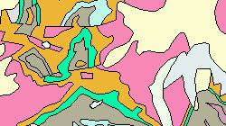
Carte géotechnique simplifiée de la Suisse (VS)
La carte géotechnique 1:500000 (GK500) de la Commission Géotechnique Suisse (SGTK) montre le sous-sol selon des critères lithologiques pétrographiques. La légende est conçu pour répondre à l'utilisation technique du sous-sol. (Gisement de ressources minérales, constructions).
Simple
- Alternate title
-
Carte lithologique et pétrographique de la Suisse 1:500000 (VS)
- Date (Creation)
- 2012-12-31
- Identifier
- 60
- Purpose
-
Représentations selon des critères lithologiques pétrographiques.
- Status
- Completed
Custodian
- Spatial representation type
- Vector
Spatial resolution
Equivalent scale
- Denominator
- 500000
- Topic category
-
- F Geoscientific information
Extent
Extent
- Description
-
Canton of Valais (VS)
))

- Maintenance and update frequency
- Not planned
Resource format
- Title
-
ESRI Enterprise Geodatabase
- Date
- GEMET themes
-
-
soil
-
- GEMET
-
-
geotechnics
-
geology
-
- geocat.ch
-
-
geologic map
-
petrography
-
lithology
-
official geodata
-
Resource constraints
- Use limitation
-
Aucune
Resource constraints
- Access constraints
- Other restrictions
- Other constraints
-
Géodonnées accessibles au public (niveau A selon l'OGéo)
- Other constraints
-
Les conditions générales d'utilisation des géodonnées du Canton du Valais font foi ( https://www.vs.ch/fr/web/guest/information-legale).
- Language
- Deutsch
- Character encoding
- UTF8
- Environment description
-
S:\Géodonnées VS\F1 Géologie\Carte géotechnique.lyr
- Subtopic Category
- F1 Geology
- Basic Geodata
- true
- Basic Geodata ID
-
48.1
- Basic Geodata Legal Level
- Federal
- Basic Geodata Type
- basicGeodata
- Distribution format
-
-
ESRI Shapefile (SHP)
-
autres formats sur demande / andere Formate auf Anfrage
-
Distributor
- Statement
-
La géométrie correspond exactement à celle des cartes géologique et tectonique de la Suisse au 1:500000. Les polygones ont en outre été attribués à l'aide de la carte géotechnique imprimée (2. éd.; 1963-1967). La résolution au sol ne peut être définie de manière exacte, la position des objets géologiques dépend de l'interprétation du géologue-cartographe. D'autres imprécisions sont dues à la pondération et à la généralisation de la carte de base.
- Hierarchy level
- Dataset
- Description
-
Attribution de code par la SGTK aux polygones de swisstopo.
- Geometric object type
- Surface
- Geometric object count
- 1573
- Reference system identifier
- EPSG:2056/CH1903+_MN95
Metadata
- Metadata identifier
- 6f81b3d6-5471-4c35-b2b6-cd97b0e07e4c
- Language
- Français
- Character encoding
- UTF8
- Language
- Deutsch
- Character encoding
- UTF8
- Language
- Italiano
- Character encoding
- UTF8
- Language
- English
- Character encoding
- UTF8
- Language
- Rumantsch
- Character encoding
- UTF8
Distributor
Type of resource
- Resource scope
- Dataset
- Metadata linkage
-
https://www.geocat.ch/geonetwork/srv/api/records/6f81b3d6-5471-4c35-b2b6-cd97b0e07e4c
- Date info (Creation)
- 2016-09-02T16:25:20Z
- Date info (Revision)
- 2026-04-13T09:38:12.951001Z
Metadata standard
- Title
-
eCH-0271