 geocat.ch
Amtliche Vermessung
Die amtliche Vermessung liefert geometrische Daten zum Grundeigentum. Die Daten sind in drei verschiedenen Modellen verfügbar. Bei jedem Bezug über den Geodatenshop werden zusätzlich aktuelle 1m-Höhenlinien abgegeben.
Simple
- Alternate title
-
AMTVERXX_COL
- Date (Creation)
- 2026-06-18
- Presentation form
- Digital map
- Purpose
-
Die amtliche Vermessung beschreibt Lage, Form und Inhalt eines Grundstücks und hält die Angaben im Plan für das Grundbuch fest. Dieser ist ein amtliches Dokument, die darin festgehaltenen Grenzverläufe von Grundstücken haben Rechtswirkung. Im Grundbuch werden weitere rechtsbezogene Informationen wie Eigentumsverhältnisse, Dienstbarkeiten, Anmerkungen oder Vormerkungen geführt.DM.01-AV-CH - offizielles Datenmodell der amtlichen Vermessung Das neutrale und unabhängige Datenmodell 2001 der amtlichen Vermessung DM.01-AV-CH legt die Struktur der Daten fest, um den Austausch von Geodaten zwischen unterschiedlichen Softwaresystemen zu gewährleisten.Das Datenmodell DM.01-AV-LU erhält zusätzliche Luzerner Erweiterungen. Beide Modelle sind in der Datenmodellierungssprache Interlis beschrieben.MOpublic - vereinfachtes Datenmodell der amtlichen VermessungMOpublic ist für Nutzer gedacht, welche Vermessungsdaten in einer einfacheren Struktur als im Bundesmodell DM.01-AV-CH nutzen möchten.Zweck von MOpublic ist es, die wichtigsten Kundenbedürfnisse abzudecken und Daten in verschiedenen Transferformaten wie ESRI Shapefile oder OGC GeoPackage (Hinweis: segmentierte Kreisbögen) anzubieten. AV-Daten in einer vereinfachten Form können zudem leichter in externe Systeme integriert werden, was den Datenaustausch zwischen dem Fachgebiet Vermessung und anderen Tätigkeitsgebieten verbessert .Datenreferenzmodell GEOBAUDas Format GEOBAU-DXF wurde für den Transfer von AV-Daten entwickelt. Die Layerdefinitionen können dem Merkblatt Daten der amtlichen Vermessung entnommen werden. Das vollständige Datenreferenzmodell GEOBAU (SN 612 020) kann bei der Schweizerischen Normen-Vereinigung SNV bezogen werden.
- Status
- On going
Publisher
Owner
- Spatial representation type
- undefined
- Topic category
-
- A Imagery base maps earth cover
Extent
Extent
- Description
-
Kanton Luzern
))
- Maintenance and update frequency
- Daily
- geocat.ch
-
-
Amtliche Vermessung/AV
-
Basiskarte
-
Grundbuch
-
Grundeigentum
-
Resource constraints
- Access constraints
- none
- Use constraints
- Copyright
Resource constraints
- Use limitation
-
öffentlich zugängliche Geobasisdaten
Resource constraints
- Access constraints
- none
- Use constraints
- none
Resource constraints
- Use limitation
-
Kostenpflichtige Daten. Nicht-kommerzielle Nutzung nur für Eigengebrauch. Kommerzielle Nutzung nur mit Bewilligung der zuständigen Stelle. Quellenangabe ist Pflicht.
Associated resource
- Association Type
- Reference to a master resource of which this one is a part
- Metadata Reference
Associated resource
- Association Type
- Reference to a master resource of which this one is a part
- Metadata Reference
Associated resource
- Association Type
- Reference to a master resource of which this one is a part
- Metadata Reference
Associated resource
- Association Type
- Reference to a master resource of which this one is a part
- Metadata Reference
Associated resource
- Association Type
- Reference to a master resource of which this one is a part
- Metadata Reference
Associated resource
- Association Type
- Reference to a master resource of which this one is a part
- Metadata Reference
Associated resource
- Association Type
- Reference to a master resource of which this one is a part
- Metadata Reference
Associated resource
- Association Type
- Reference to a master resource of which this one is a part
- Metadata Reference
Associated resource
- Association Type
- Reference to a master resource of which this one is a part
- Metadata Reference
Associated resource
- Association Type
- Reference to a master resource of which this one is a part
- Metadata Reference
Associated resource
- Association Type
- Reference to a master resource of which this one is a part
- Metadata Reference
Associated resource
- Association Type
- Reference to a master resource of which this one is a part
- Metadata Reference
Associated resource
- Association Type
- Reference to a master resource of which this one is a part
- Metadata Reference
Associated resource
- Association Type
- Reference to a master resource of which this one is a part
- Metadata Reference
Associated resource
- Association Type
- Reference to a master resource of which this one is a part
- Metadata Reference
Associated resource
- Association Type
- Reference to a master resource of which this one is a part
- Metadata Reference
Associated resource
- Association Type
- Reference to a master resource of which this one is a part
- Metadata Reference
Associated resource
- Association Type
- Reference to a master resource of which this one is a part
- Metadata Reference
Associated resource
- Association Type
- Reference to a master resource of which this one is a part
- Metadata Reference
Associated resource
- Association Type
- Reference to a master resource of which this one is a part
- Metadata Reference
Associated resource
- Association Type
- Reference to a master resource of which this one is a part
- Metadata Reference
Associated resource
- Association Type
- Reference to a master resource of which this one is a part
- Metadata Reference
Associated resource
- Association Type
- Reference to a master resource of which this one is a part
- Metadata Reference
Associated resource
- Association Type
- Reference to a master resource of which this one is a part
- Metadata Reference
Associated resource
- Association Type
- Reference to a master resource of which this one is a part
- Metadata Reference
Associated resource
- Association Type
- Reference to a master resource of which this one is a part
- Metadata Reference
Associated resource
- Association Type
- Reference to a master resource of which this one is a part
- Metadata Reference
Associated resource
- Association Type
- Reference to a master resource of which this one is a part
- Metadata Reference
Associated resource
- Association Type
- Reference to a master resource of which this one is a part
- Metadata Reference
Associated resource
- Association Type
- Reference to a master resource of which this one is a part
- Metadata Reference
Associated resource
- Association Type
- Reference to a master resource of which this one is a part
- Metadata Reference
- Distribution format
-
-
DXF-GEOBAU (.dxf)
-
ESRI Shapefile MOPublic (.shp)
-
ESRI Geodatabase MOPublic (.gdb)
-
OGC Geopackage MOPublic (.gpkg)
-
Interlis DM.01-LU (.itf)
-
Interlis DM.01-CH (.itf)
-
Point of contact
Digital transfer options
- OnLine resource
-
Datenshop
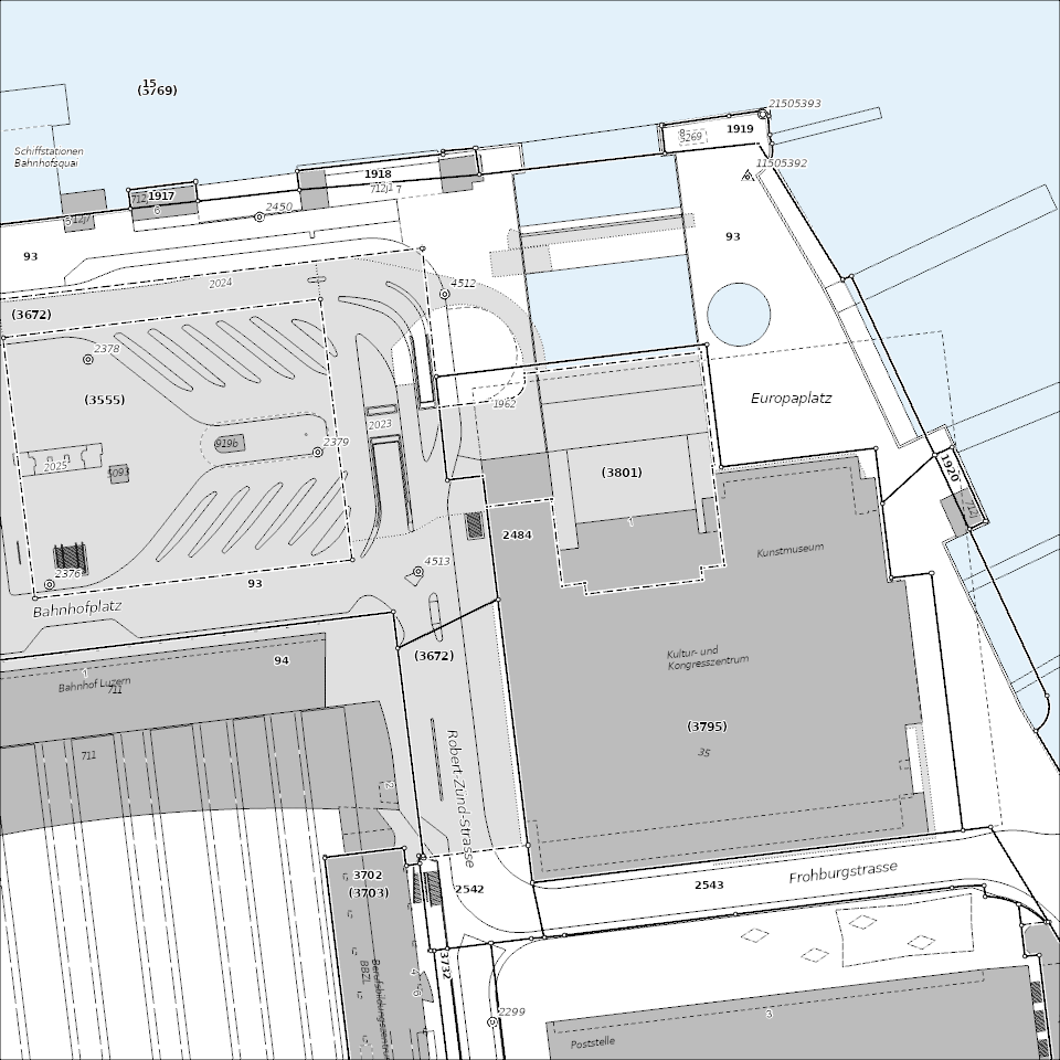
Produktansicht Geodatenshop
- Statement
-
unbekannt
- Reference system identifier
- EPSG:2056
- Maintenance and update frequency
- As needed
Metadata
- Metadata identifier
- 6f6bae98-05f8-4da9-b800-b7cdddb63e38
- Language
- Deutsch
- Character encoding
- UTF-8
Point of contact
Type of resource
- Resource scope
- Dataset
- Metadata linkage
-
https://www.geocat.ch/geonetwork/srv/api/records/6f6bae98-05f8-4da9-b800-b7cdddb63e38
- Date info (Creation)
- 2021-09-01
- Date info (Revision)
- 2026-06-20T03:13:02.142005Z
Metadata standard
- Title
-
ISO19115.3-2018.che
)))