geocat.ch
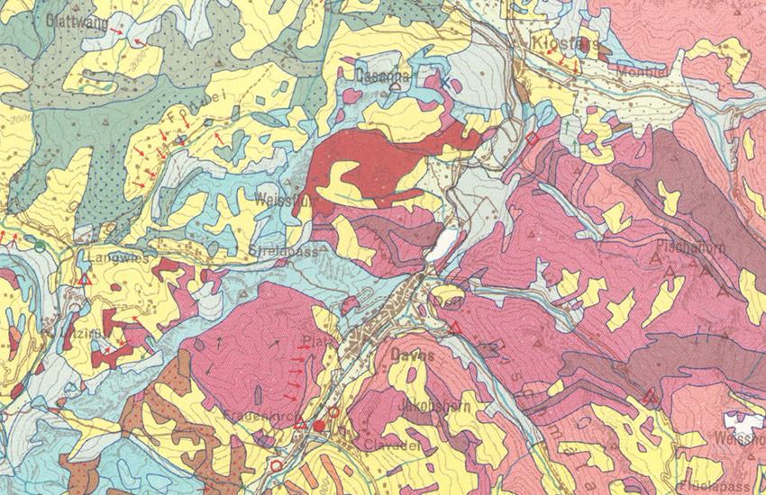
Lithological-petrographic map of Switzerland 1:200000
The Lithological-petrographic map of Switzerland 1:200,000 provides an overview of the subsurface classified according to lithological-petrographic criteria. The legend is designed in particular to facilitate the identification of the possible usages of the subsurface (e.g. extraction of mineral resources, construction projects). The point data overlay indicates the location of extraction and/or processing sites of mineral raw materials (Survey: 1963–1967).
(Original name: Geotechnical map of Switzerland 1:200,000)
Simple
- Alternate title
-
Litho-petrographic map 200
- Date (Creation)
- 1967-01-01
- Identifier
- ch.swisstopo.geologie-geotechnik-gk200
- Presentation form
- Hardcopy map
- Website
-
http://www.sgtk.ch/main.asp?content=inhalt/produkte/baugrund_geotechnische_karten.htm&nav=23
- Purpose
-
Darstellung des geologischen Untergrunds nach lithologisch-petrografischen Kriterien; Übersicht über Vorkommen, Abbau und Verarbeitung mineralischer Rohstoffe der Schweiz.
Resource provider
Point of contact
Owner
- Spatial representation type
- paperMap
Spatial resolution
Equivalent scale
- Denominator
- 200000
- Topic category
-
- F Geoscientific information
Extent
Extent
- Description
-
Switzerland
))

- Maintenance and update frequency
- Not planned
- Duration of Conservation
- 275
- Appraisal of Archival Value
- A
- Reason for Archiving Value
- Evidence of business practice
- geocat.ch
-
-
official geodata
-
Conservation and archiving planning AAP - Confederation
-
lithology
-
opendata.swiss
-
petrography
-
- GEMET
-
-
excavation site
-
geotechnics
-
quarry
-
- GEMET - INSPIRE themes, version 1.0
-
-
Geology
-
Mineral resources
-
- geocat.ch
-
-
FSDI Federal Spatial Data Infrastructure
-
Associated resource
- Title
-
Geotechnisches Kartenwerk
- Association Type
- Reference to a master resource of which this one is a part
- Language
- Deutsch
- Character encoding
- UTF8
- Subtopic Category
- F1 Geology
- Basic Geodata
- true
- Basic Geodata ID
-
48.2
- Basic Geodata Legal Level
- Federal
- Distribution format
-
-
GeoTIFF (GEOTIFF)
-
Digital transfer options
- OnLine resource
-
Vorschau map.geo.admin.ch
Preview map.geo.admin.ch
Digital transfer options
- OnLine resource
-
ch.swisstopo.geologie-geotechnik-gk200
WMS-FSDI service, layer "Geotechnical Map 200"
Digital transfer options
- OnLine resource
-
ch.swisstopo.geologie-geotechnik-gk200
WMTS-FSDI service, layer "Geotechnical Map 200"
Digital transfer options
- OnLine resource
-
Fachgruppe Georessourcen Schweiz
Digital transfer options
- OnLine resource
-
Rohstoffinformationssystem
Digital transfer options
- OnLine resource
-
Geologie-Portal: Geotechnik & Ingenieurgeologie
Digital transfer options
- OnLine resource
-
RESTful API von geo.admin.ch
RESTful API from geo.admin.ch
Digital transfer options
- OnLine resource
-
Permalink opendata.swiss
Permalink opendata.swiss
- Statement
-
Der geologische Untergund wurde auf der Basis des Geologischen Atlas 25'000 kompiliert. In Gebieten, in denen dieser bei Erstellung nicht vorhanden war, wurde auf geologische Spezialkarten und weitere publizierte Unterlagen zurückgegriffen. Die Daten wurden durch zum Teil unpublizierte Studien ergänzt. Die Auflösung am Boden kann bei abgeleitetet Themenkarten nicht exakt bestimmt werden, da die Lage der geologischen Objekte der Interpretation des kartierenden Geologen unterliegt. Sie weichen zusätzlich durch Gewichtung und Generalisierung vom eigentlichen Ort ab.
- Hierarchy level
- Series
- Reference system identifier
- Referenzsystem entsprechend der zugrundeliegenden topographischen Karte (CH1903)
Metadata
- Metadata identifier
- 6dd16d72-047b-4489-91dc-b36eeabf972e
- Language
- Deutsch
- Character encoding
- UTF8
- Language
- Français
- Character encoding
- UTF8
- Language
- Italiano
- Character encoding
- UTF8
- Language
- English
- Character encoding
- UTF8
- Language
- Rumantsch
- Character encoding
- UTF8
Point of contact
Type of resource
- Resource scope
- Dataset
Type of resource
- Resource scope
- Series
- Metadata linkage
-
https://www.geocat.ch/geonetwork/srv/api/records/6dd16d72-047b-4489-91dc-b36eeabf972e
- Date info (Creation)
- 2009-10-13T12:00:00Z
- Date info (Revision)
- 2026-05-20T10:55:53.538466Z
Metadata standard
- Title
-
eCH-0271