geocat.ch
Schwerekarte der Schweiz (Bouguer-Anomalien) 1:500000
Carte gravimétrique de la Suisse (Anomalies de Bouguer) 1:500000
Carta gravimetrica della Svizzera (anomalie di Bouguer) 1:500000
Gravimetric Map of Switzerland (Bouguer Anomalies) 1:500000
Charta gravimetrica da la Svizra (anomalias da Bouguer) 1:500000
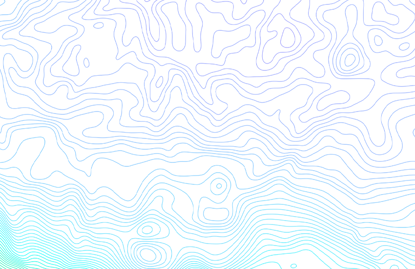
Die Fallbeschleunigung oder Schwere hängt vom Ort des Messpunktes und der Massenverteilung im Untergrund ab. Als Bouguer-Anomalie bezeichnet man die Differenz zwischen der in einem bestimmten Punkt auf der Erdoberfläche gemessenen Schwere und jenem Schwerewert, welchen man für eine schalenförmig homogene Erde am selben Punkt erwarten würde. Die Bouguer-Anomalien sind mit Hilfe der internationalen Schwereformel von 1967 berechnet, wobei die Geländeeinwirkung bis 167 km Entfernung (Zone O2 nach Hayford) mit konstanter Dichte von 2670 kg/m3 berücksichtigt ist. Die Karte verdeutlicht einerseits die regionalen negativen Schwereanomalien entlang der Alpen und anderseits die positive Anomalie der Sesia-Finero-Zone, welche einen Massenüberschuss im Erdinnern bedeutet.- Von E. KLINGELE & R. OLIVIER, 1979- Neue Ausgabe R. OLIVIER, B. DUMONT & E. KLINGELE, 2008
L’accélération de la pesanteur dépend de la position du point de mesure ainsi que des variations latérales des densités du sous-sol. On nomme anomalie de Bouguer la différence entre l’intensité de la pesanteur mesurée en un point donnée de la surface terrestre et la valeur calculée au même point d’un modèle de Terre idéale, dotée d’un croûte homogène. Les calculs des anomalies gravitaires de la croûte terrestre se basent sur la formule internationale de gravité de 1967. L'incidence de la topographie a été prise en compte avec une densité constante de 2670 kg / m3 jusqu’à 167 km (zone O2 de Hayford). La carte met en évidence les anomalies régionales négatives de la pesanteur de la chaîne alpine et d'autre part l'anomalie positive de la zone Sesia–Finero qui signifie un excédent de masse en profondeur.- Par E. KLINGELE & R. OLIVIER, 1979- Nouvelle édition R. OLIVIER, B. DUMONT & E. KLINGELE, 2008
L'accelerazione di gravità (o accelerazione gravitazionale) dipende dalla posizione del punto di misurazione nonché dalla distribuzione della massa nel sottosuolo. L’anomalia di Bouguer esprime la differenza tra la gravità misurata e il relativo valore teorico per un modello terrestre ideale a crosta omogenea, tenuto conto di diversi parametri quali l’altitudine, la latitudine e l’influenza della topografia. Il calcolo delle anomalie di Bouguer si basa sull’applicazione della formula internazionale per la gravità del 1967 e tiene conto dell’effetto delle irregolarità del terreno fino a 167 km di distanza (zona O2 secondo Hayford) con una massa specifica costante di 2670 kg/m3. La carta evidenzia da un lato le anomalie regionali negative della gravità della catena alpina, dall’altro l’anomalia positiva della zona Sesia–Finero che esprime un'eccedenza di massa in profondità. E. KLINGELE & R. OLIVIER, 1979- Neue Ausgabe R. OLIVIER, B. DUMONT & E. KLINGELE, 2008
Gravitational acceleration or gravity depends on the location of the measuring point and the mass distribution in the subsurface structure. A Bouguer anomaly is the difference between the gravity measured at a particular point on the Earth's surface and the gravity value expected at the same point for an Earth model with a homogeneous crust. Bouguer anomalies are calculated using the International Gravity Formula of 1967. Topographic effects are taken into account using a constant density of 2670 kg/m3 to a depth of 167 km (Hayford Zone O2). The map highlights, on the one hand, the regional negative gravity anomalies along the Alps and, on the other hand, the positive anomalies in the Sesia-Finero zone, which signify a mass excess in the Earth's interior. By E. Klingelé & R. Olivier, 1979. New edition: R. Olivier, B. Dumont & E. Klingelé, 2008.
La gravitad dependa dal lieu dal punct da mesiraziun e da la distribuziun da la massa en il sutterren. Anomalias da Bouguer numnan ins la differenza tranter la gravitad ch'è vegnida mesirada en in punct fixà sin la surfatscha da la terra e la valur da la gravitad calculada en il medem punct per in model terrester ideal cun crusta da terra omogena. Las anomalias da Bouguer èn calculadas cun agid da la furmla internaziunala da gravitad da l'onn 1967. L'influenza da la topografia è vegnida resguardada cun ina densitad constanta da 2670 kg/m3 fin ad ina distanza da 167 km (zona O2 tenor Hayford). La charta mussa d'ina vart las anomalias regiunalas negativas da la gravitad per lung da las Alps e da l'autra vart l'anomalia positiva da la zona Sesia-Finero, la quala signifitga in surpli da massa a l'intern da la terra. – Dad E. KLINGELE & R. OLIVIER, 1979 – Nova ediziun R. OLIVIER, B. DUMONT & E. KLINGELE, 2008
Simple
-
Autre titreAltri nomi o acronimiAlternate titleAlternate titleAlternativtitel
-
Bouguer-Anomalien 500
Anomalies de Bouguer 500
Anomalia di Bouguer 500
Bouguer anomalies 500
Anomalias da Bouguer 500
-
Date (Publication)Data (Pubblicazione)Date (Publication)Date (Publication)Datum (Publikation)
- 1979-12-31
-
IdentifiantIdentificatoreIdentifierIdentifierKennung
- ch.swisstopo.geologie-geodaesie-bouguer_anomalien
-
NomNomeNameNameName
-
GeoKarten 500
-
Autres informations de référenceAltre informazioni di riferimentoOther citation detailsOther citation detailsWeitere Referenzinformationen
-
Neue Ausgabe 2008
Nouvelle édition 2008
-
ButScopoPurposePurposeZweck
-
Übersicht über das Schwerefeld in der Schweiz
Vue d'ensemble du champ gravimétrique en Suisse
-
ÉtatStatoStatusStatusBearbeitungsstatus
-
TerminéCompletatoCompletedCompletedAbgeschlossen
Distributeur
Distributore
Distributor
Distributor
Verteiler
Organisateur
Originatore
Originator
Originator
Urheber
Point de contact
Punto di contatto
Point of contact
Point of contact
Ansprechpartner
Propriétaire
Proprietario
Owner
Owner
Eigentümer
-
Type de représentation spatialeTipo di rappresentazione spazialeSpatial representation typeSpatial representation typeRäumliche Darstellungsart
-
paperMappaperMappaperMappaperMappaperMap
Résolution spatiale
Risoluzione spaziale
Spatial resolution
Spatial resolution
Räumliche Auflösung
Fraction représentative
Frazione rappresentativa
Equivalent scale
Equivalent scale
Vergleichsmassstab
-
DénominateurDenominatoreDenominatorDenominatorMassstabszahl
- 500000
-
Catégorie de thèmeCategoria ISOTopic categoryTopic categoryThematik
-
-
F Informations géoscientifiquesF Informazioni geoscientificheF Geoscientific informationF Geoscientific informationF Erdwissenschaften
-
Étendue
Estensione
Extent
Extent
Ausdehnung
Étendue
Estensione
Extent
Extent
Ausdehnung
-
DescriptionDescrizioneDescriptionDescriptionBeschreibung
-
National Map 1:500'000
Landeskarte 1:500'000
Carte nationale 1:500'000
Carta nazionale 1:500'000
Landeskarte 1:500'000
-
Identifiant géographiqueIdentificatore geograficoGeographic identifierGeographic identifierGeografische Kennung
- NM500LK500CN500CN500LK500
))

-
Fréquence de mise à jourFrequenza di aggiornamentoMaintenance and update frequencyMaintenance and update frequencyWartungsintervall
-
Comme nécessaireSecondo necessitàAs neededAs neededBei Bedarf
-
Durée de conservationDurata di conservazioneDuration of ConservationDuration of ConservationAufbewahrungsdauer NV in Jahren
- 275
-
Évaluation de la valeur archivistiqueValutazione del valore archivisticoAppraisal of Archival ValueAppraisal of Archival ValueBewertung Archivwürdigkeit
-
AAAAA
-
Raison de la valeur d'archivageMotivo del valore archivisticoReason for Archiving ValueReason for Archiving ValueBegründung Archivwürdigkeit
-
Preuve de la pratique couranteProva della pratica commercialeEvidence of business practiceEvidence of business practiceNachweis der Geschäftspraxis
- geocat.ch
-
-
carte géophysique
carta geofisica
geophysical map
-
e-geo.ch
e-geo.ch
e-geo.ch
-
géodonnées de base
geodati di base
official geodata
-
anomalie de bouguer
anomalie di bouguer
bouguer anomaly
-
Planification de la conservation et de l'archivage AAP - Conféderation
Pianificazione della conservazione e dell’archiviazione AAP - Confederazione
Conservation and archiving planning AAP - Confederation
-
gravimétrie
gravimetria
gravimetry
-
opendata.swiss
opendata.swiss
opendata.swiss
opendata.swiss
-
- GEMET
-
-
géophysique
geofisica
geophysics
-
- GEMET - INSPIRE themes, version 1.0
-
-
Géologie
Geologia
Geology
-
- geocat.ch
-
-
BGDI Bundesgeodaten-Infrastruktur
IFDG l’Infrastructure Fédérale de données géographiques
IFDG Infrastruttura federale dei dati geografici
FSDI Federal Spatial Data Infrastructure
-
Ressource associée
Risorsa associata
Associated resource
Associated resource
Verlinkte Ressource
-
TitreTitoloTitleTitleTitel
-
Geophysikalisches Kartenwerk
Cartes géophysiques
Carte geofisiche
Geophysical maps
-
Type d'associationTipo di associazioneAssociation TypeAssociation TypeAssoziationstyp
-
Citation de travail plus largeCitazione di un'opera più ampiaReference to a master resource of which this one is a partReference to a master resource of which this one is a partÜbergeordneter Datenbestand
-
LangueLinguaLanguageLanguageSprache
- Deutsch
-
Encodage de caractèresCodifica dei caratteriCharacter encodingCharacter encodingZeichenkodierung
-
Utf8UTF8UTF8UTF8Utf8
-
LangueLinguaLanguageLanguageSprache
- Français
-
Encodage de caractèresCodifica dei caratteriCharacter encodingCharacter encodingZeichenkodierung
-
Utf8UTF8UTF8UTF8Utf8
-
Catégorie de sous-thèmeCategoria di sottotemaSubtopic CategorySubtopic CategoryThematische Unterkategorien
-
F1 GéologieF1 GeologiaF1 GeologyF1 GeologyF1 Geologie
-
Géodonnées de baseGeodati di baseBasic GeodataBasic GeodataGeobasisdaten
- true
-
Identifiant Géodonnées de baseIdentificativo dei geodati di baseBasic Geodata IDBasic Geodata IDIdentifikator des Geobasisdatensatzes
-
47.4
-
Niveau des géodonnées de baseLivello legale dei geodati di baseBasic Geodata Legal LevelBasic Geodata Legal LevelGeobasisdatenebene
-
FédéralFederaleFederalFederalNational
-
Format de distributionFormato (codifica)Distribution formatDistribution formatAbgabeformat
-
-
analog
-
GeoTIFF (GEOTIFF)
-
ESRI Shapefile (SHP)
-
Options de transfert numérique
Opzioni di trasferimento digitale
Digital transfer options
Digital transfer options
Optionen für die digitale Übertragung
-
Ressource en ligneRisorsa onlineOnLine resourceOnLine resourceOnline
-
Vorschau map.geo.admin.ch
Vorschau map.geo.admin.chAperçu map.geo.admin.chPrevisione map.geo.admin.chPreview map.geo.admin.ch
Options de transfert numérique
Opzioni di trasferimento digitale
Digital transfer options
Digital transfer options
Optionen für die digitale Übertragung
-
Ressource en ligneRisorsa onlineOnLine resourceOnLine resourceOnline
-
ch.swisstopo.geologie-geodaesie-bouguer_anomalien
WMS-BGDI Dienst, Layer "Bouguer-Anomalien 500"Service WMS-IFDG, couche "Anomalies de Bouguer 500"Servizio WMS-IFDG, strato "Anomalia di Bouguer 500"WMS-FSDI service, layer "Bouguer anomalies 500"WMS-BGDI Dienst, Layer "Bouguer-Anomalien 500"
Options de transfert numérique
Opzioni di trasferimento digitale
Digital transfer options
Digital transfer options
Optionen für die digitale Übertragung
-
Ressource en ligneRisorsa onlineOnLine resourceOnLine resourceOnline
-
ch.swisstopo.geologie-geodaesie-bouguer_anomalien
WMTS-BGDI Dienst, Layer "Bouguer-Anomalien 500"Service WMTS-IFDG, couche , Layer "Anomalies de Bouguer 500"Servizio WMTS-IFDG, strato "Anomalia di Bouguer 500"WMTS-FSDI service, layer "Bouguer anomalies 500"WMTS-BGDI Dienst, Layer "Bouguer-Anomalien 500"
Options de transfert numérique
Opzioni di trasferimento digitale
Digital transfer options
Digital transfer options
Optionen für die digitale Übertragung
Options de transfert numérique
Opzioni di trasferimento digitale
Digital transfer options
Digital transfer options
Optionen für die digitale Übertragung
Options de transfert numérique
Opzioni di trasferimento digitale
Digital transfer options
Digital transfer options
Optionen für die digitale Übertragung
Options de transfert numérique
Opzioni di trasferimento digitale
Digital transfer options
Digital transfer options
Optionen für die digitale Übertragung
Options de transfert numérique
Opzioni di trasferimento digitale
Digital transfer options
Digital transfer options
Optionen für die digitale Übertragung
Options de transfert numérique
Opzioni di trasferimento digitale
Digital transfer options
Digital transfer options
Optionen für die digitale Übertragung
-
Ressource en ligneRisorsa onlineOnLine resourceOnLine resourceOnline
-
RESTful API von geo.admin.ch
RESTful API von geo.admin.chRESTful API de geo.admin.chRESTful API da geo.admin.chRESTful API from geo.admin.chRESTful API dad geo.admin.ch
-
Généralités sur la provenanceInformazioni generali sulla provenienzaStatementStatementErklärung
-
Diese Karte stellt vor dem Hintergrund der Landeskarte 1:500'000 die Bouguer-Anomalien dar.
Cette carte représente les anomalies de Bouguer sur le fond de la Carte nationale 1:500’000.
-
NiveauLivelloHierarchy levelHierarchy levelBezugsebene
-
Jeu de donnéesSet di datiDatasetDatasetDatenbestand
-
Nom du système de référenceNome del sistema di riferimentoReference system identifierReference system identifierName des Referenzsystems
- EPSG:21781
Metadata
-
Identifiant des métadonnéesIdentificativo della schedaMetadata identifierMetadata identifierIdentifikator des Metadatensatzes
- 618c9697-129f-47c7-830a-7a256b4c2499
-
LangueLinguaLanguageLanguageSprache
- Deutsch
-
Encodage de caractèresCodifica dei caratteriCharacter encodingCharacter encodingZeichenkodierung
-
Utf8UTF8UTF8UTF8Utf8
-
LangueLinguaLanguageLanguageSprache
- Français
-
Encodage de caractèresCodifica dei caratteriCharacter encodingCharacter encodingZeichenkodierung
-
Utf8UTF8UTF8UTF8Utf8
-
LangueLinguaLanguageLanguageSprache
- Italiano
-
Encodage de caractèresCodifica dei caratteriCharacter encodingCharacter encodingZeichenkodierung
-
Utf8UTF8UTF8UTF8Utf8
-
LangueLinguaLanguageLanguageSprache
- English
-
Encodage de caractèresCodifica dei caratteriCharacter encodingCharacter encodingZeichenkodierung
-
Utf8UTF8UTF8UTF8Utf8
-
LangueLinguaLanguageLanguageSprache
- Rumantsch
-
Encodage de caractèresCodifica dei caratteriCharacter encodingCharacter encodingZeichenkodierung
-
Utf8UTF8UTF8UTF8Utf8
Point de contact
Punto di contatto
Point of contact
Point of contact
Ansprechpartner
Type de ressource
Tipo di risorsa
Type of resource
Type of resource
Anwendungsbereich der Metadaten
-
Domaine d'application de la ressourceAmbito di applicazione della risorsaResource scopeResource scopeDomäne der Ressourcenanwendung
-
Jeu de donnéesSet di datiDatasetDatasetDatenbestand
-
Lien vers la métadonnéeCollegamento ai metadatiMetadata linkageMetadata linkageLink zu den Metadaten
-
Informations de date (Création)Informazioni sulla data (Creazione)Date info (Creation)Date info (Creation)Datumsangaben (Erstellung)
- 2010-04-19T11:15:35Z
-
Informations de date (Révision)Informazioni sulla data (Revisione)Date info (Revision)Date info (Revision)Datumsangaben (Aktualisierung)
- 2026-04-13T09:18:13.219465Z
Norme des métadonnées
Standard dei metadati
Metadata standard
Metadata standard
Metadatenstandard
-
TitreTitoloTitleTitleTitel
-
eCH-0271