geocat.ch
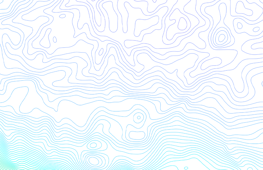
Gravimetric Map of Switzerland (Bouguer Anomalies) 1:500000
Gravitational acceleration or gravity depends on the location of the measuring point and the mass distribution in the subsurface structure. A Bouguer anomaly is the difference between the gravity measured at a particular point on the Earth's surface and the gravity value expected at the same point for an Earth model with a homogeneous crust. Bouguer anomalies are calculated using the International Gravity Formula of 1967. Topographic effects are taken into account using a constant density of 2670 kg/m3 to a depth of 167 km (Hayford Zone O2). The map highlights, on the one hand, the regional negative gravity anomalies along the Alps and, on the other hand, the positive anomalies in the Sesia-Finero zone, which signify a mass excess in the Earth's interior. By E. Klingelé & R. Olivier, 1979. New edition: R. Olivier, B. Dumont & E. Klingelé, 2008.
Simple
- Alternate title
-
Bouguer anomalies 500
- Date (Publication)
- 1979-12-31
- Identifier
- ch.swisstopo.geologie-geodaesie-bouguer_anomalien
- Name
-
GeoKarten 500
- Other citation details
-
Neue Ausgabe 2008
- Purpose
-
Übersicht über das Schwerefeld in der Schweiz
- Status
- Completed
Distributor
Originator
Point of contact
Owner
- Spatial representation type
- paperMap
Spatial resolution
Equivalent scale
- Denominator
- 500000
- Topic category
-
- F Geoscientific information
Extent
Extent
- Description
-
National Map 1:500'000
- Geographic identifier
- NM500
))

- Maintenance and update frequency
- As needed
- Duration of Conservation
- 275
- Appraisal of Archival Value
- A
- Reason for Archiving Value
- Evidence of business practice
- geocat.ch
-
-
geophysical map
-
e-geo.ch
-
official geodata
-
bouguer anomaly
-
Conservation and archiving planning AAP - Confederation
-
gravimetry
-
opendata.swiss
-
- GEMET
-
-
geophysics
-
- geocat.ch
-
-
FSDI Federal Spatial Data Infrastructure
-
Associated resource
- Title
-
Geophysical maps
- Association Type
- Reference to a master resource of which this one is a part
- Language
- Deutsch
- Character encoding
- UTF8
- Language
- Français
- Character encoding
- UTF8
- Subtopic Category
- F1 Geology
- Basic Geodata
- true
- Basic Geodata ID
-
47.4
- Basic Geodata Legal Level
- Federal
- Distribution format
-
-
analog
-
GeoTIFF (GEOTIFF)
-
ESRI Shapefile (SHP)
-
Digital transfer options
- OnLine resource
-
Vorschau map.geo.admin.ch
Preview map.geo.admin.ch
Digital transfer options
- OnLine resource
-
ch.swisstopo.geologie-geodaesie-bouguer_anomalien
WMS-FSDI service, layer "Bouguer anomalies 500"
Digital transfer options
- OnLine resource
-
ch.swisstopo.geologie-geodaesie-bouguer_anomalien
WMTS-FSDI service, layer "Bouguer anomalies 500"
Digital transfer options
Digital transfer options
Digital transfer options
Digital transfer options
Digital transfer options
- OnLine resource
-
RESTful API von geo.admin.ch
RESTful API from geo.admin.ch
- Statement
-
Diese Karte stellt vor dem Hintergrund der Landeskarte 1:500'000 die Bouguer-Anomalien dar.
- Hierarchy level
- Dataset
- Reference system identifier
- EPSG:21781
Metadata
- Metadata identifier
- 618c9697-129f-47c7-830a-7a256b4c2499
- Language
- Deutsch
- Character encoding
- UTF8
- Language
- Français
- Character encoding
- UTF8
- Language
- Italiano
- Character encoding
- UTF8
- Language
- English
- Character encoding
- UTF8
- Language
- Rumantsch
- Character encoding
- UTF8
Point of contact
Type of resource
- Resource scope
- Dataset
- Metadata linkage
-
https://www.geocat.ch/geonetwork/srv/api/records/618c9697-129f-47c7-830a-7a256b4c2499
- Date info (Creation)
- 2010-04-19T11:15:35Z
- Date info (Revision)
- 2026-04-13T09:18:13.219465Z
Metadata standard
- Title
-
eCH-0271