geocat.ch
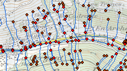
Réseau hydrographique cantonal
Les données du Réseau hydrographique cantonal contiennent la géométrie, la nomenclature, la typologie, etc.
Simple
- Alternate title
-
Réseau hydrographique cantonal
- Date (Creation)
- 2010-07-31
- Identifier
- 146
- Purpose
-
fournir une base de travail à l'administration cantonal pour définir l'inventaire cantonal des eaux superficielles publiques.
- Status
- Completed
Custodian
- Spatial representation type
- Vector
Spatial resolution
Equivalent scale
- Denominator
- 10000
- Topic category
-
- I Inland waters
Extent
Extent
- Description
-
Canton of Valais (VS)
))

- Maintenance and update frequency
- Irregular
Resource format
- Title
-
ESRI Enterprise Geodatabase
- Date
- GEMET themes
-
-
water
-
- GEMET
-
-
hydrography
-
watercourse
-
Resource constraints
- Use limitation
-
Aucunes
Resource constraints
- Access constraints
- Other restrictions
- Other constraints
-
Géodonnées accessibles au public (niveau A selon l'OGéo)
- Other constraints
-
Les conditions générales d'utilisation des géodonnées du Canton du Valais font foi ( https://www.vs.ch/fr/web/guest/information-legale).
- Language
- Français
- Character encoding
- UTF8
- Environment description
-
S:\Géodonnées VS\I Hydrographie\Réseau hydrographique cantonale (RHC10K)
- Distribution format
-
-
ESRI Shapefile (SHP)
-
OGC Web Map Service (WMS)
-
Distributor
Digital transfer options
- OnLine resource
-
0
INV_CE_Plans_eau
Digital transfer options
- OnLine resource
-
1
INV_CE_Nomenclature
Digital transfer options
- OnLine resource
-
3
INV_CE_Canaux
Digital transfer options
- OnLine resource
-
6
INV_CE_Localisation
- Statement
-
Digitalisation des cours d'eau sur le plan d'ensemble ou mensuration officielle
- Hierarchy level
- Dataset
- Description
-
Digitalisation
Equivalent scale
- Denominator
- 10000
- Geometric object type
- Complex
- Geometric object count
- 13452
- Reference system identifier
- EPSG:2056/CH1903+_MN95
Metadata
- Metadata identifier
- 561138fa-a041-435c-81c5-99421502af56
- Language
- Français
- Character encoding
- UTF8
- Language
- Deutsch
- Character encoding
- UTF8
- Language
- Italiano
- Character encoding
- UTF8
- Language
- English
- Character encoding
- UTF8
- Language
- Rumantsch
- Character encoding
- UTF8
Distributor
Type of resource
- Resource scope
- Dataset
- Metadata linkage
-
https://www.geocat.ch/geonetwork/srv/api/records/561138fa-a041-435c-81c5-99421502af56
- Date info (Creation)
- 2016-08-22T13:31:38Z
- Date info (Revision)
- 2026-04-13T09:21:14.384948Z
Metadata standard
- Title
-
eCH-0271