geocat.ch
National Map 1:1 million
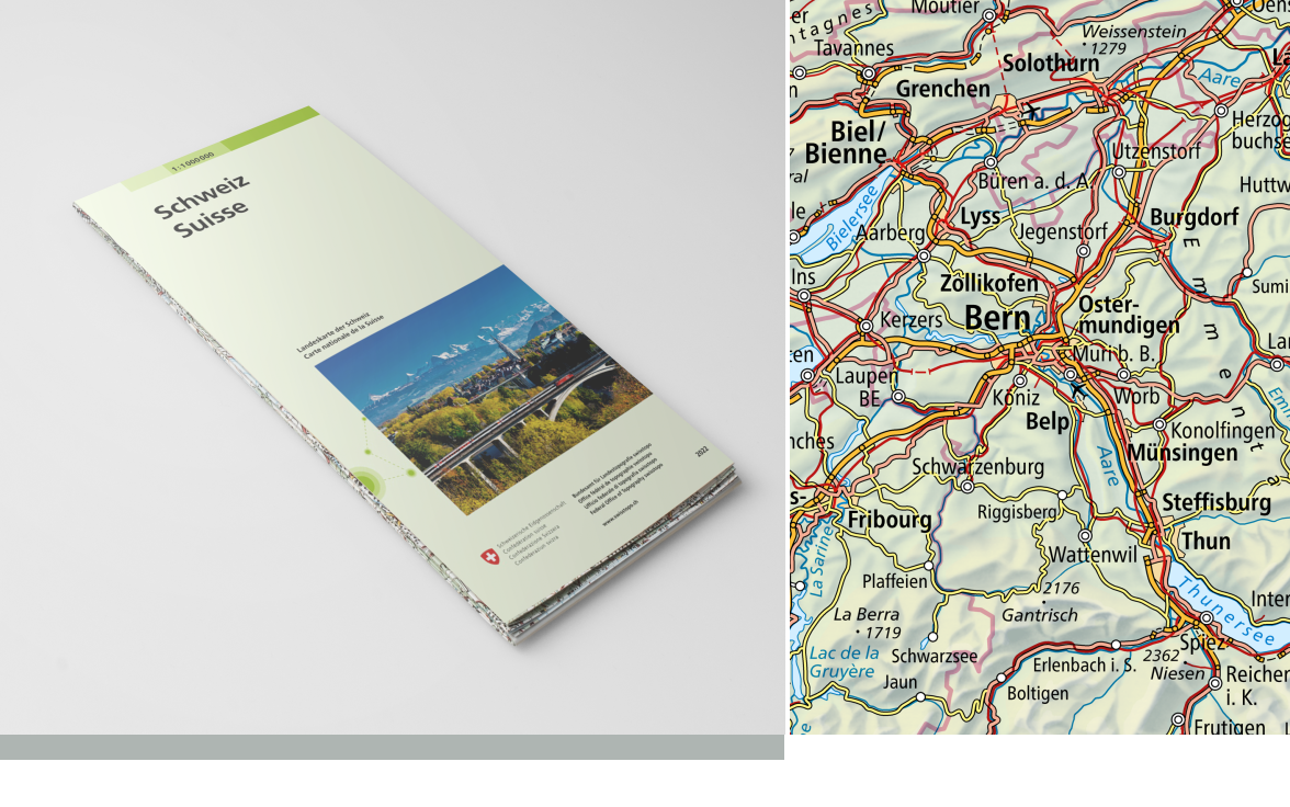
The National Map 1:1 million is a small-scale topographic map giving an overview of Central Europe: Switzerland and its neighbours from Lyons to Salzburg and from Strasbourg to Genoa on a handy overview map (Paris, Vienna, Frankfurt and Marseille on one sheet). The National Map 1:1 million is published in analogue format as a printed map and in digital format as the Swiss Map Raster and Swiss Map Vector.
Simple
- Alternate title
-
National Map 1:1 million
- Date (Creation)
- 1992-01-01T00:00:00
- Date (Revision)
- 2026-01-01
- Identifier
- ch.swisstopo.pixelkarte-farbe-pk1000.noscale
- Presentation form
- Hardcopy map
- Presentation form
- Digital map
- Purpose
-
Georeferenzdaten des Bundesrechts
- Status
- On going
Point of contact
Owner
- Spatial representation type
- paperMap
- Spatial representation type
- Grid
Spatial resolution
Equivalent scale
- Denominator
- 1000000
- Topic category
-
- A Imagery base maps earth cover
Extent
Extent
- Description
-
National map 1:1'000'000
- Geographic identifier
- NM1000
))

- Maintenance and update frequency
- Annually
- Duration of Conservation
- 275
- Appraisal of Archival Value
- A
- Reason for Archiving Value
- Evidence of business practice
- geocat.ch
-
-
terrain representation
-
general map
-
opendata.swiss
-
national map
-
official geodata
-
Conservation and archiving planning AAP - Confederation
-
traffic network
-
- GEMET
-
-
water (geographic)
-
border
-
relief (land)
-
cartography
-
- GEMET - INSPIRE themes, version 1.0
-
-
Geographical names
-
- geocat.ch
-
-
FSDI Federal Spatial Data Infrastructure
-
- geocat.ch
-
-
topography
-
- GEMET
-
-
map chart
-
Resource constraints
- Other constraints
- Opendata BY: Open use. Must provide the source.
Associated resource
- Title
-
Landeskartenwerk 1:25'000 bis 1:1 Mio.
- Association Type
- Reference to a master resource of which this one is a part
- Language
- Deutsch
- Character encoding
- UTF8
- Language
- Français
- Character encoding
- UTF8
- Language
- Italiano
- Character encoding
- UTF8
- Language
- Rumantsch
- Character encoding
- UTF8
- Subtopic Category
- A1 Base Maps, Landscape Models
- Basic Geodata
- true
- Basic Geodata ID
-
42.6
- Basic Geodata Legal Level
- Federal
- Basic Geodata Type
- Reference Geodata
- Distribution format
-
-
Cloud Optimized GeoTIFF (TIFF / TIF)
-
OGC Geopackage (GPKG)
-
ESRI File Geodatabase FileGDB (GDB)
-
analog
-
Point of contact
- Hours of service
-
07h45 - 11h45 / 13h30 - 17h00
Point of contact
Digital transfer options
- OnLine resource
-
Vorschau map.geo.admin.ch
Preview map.geo.admin.ch
Digital transfer options
- OnLine resource
-
ch.swisstopo.pixelkarte-farbe-pk1000.noscale
WMS-FSDI service, layer "National Map 1:1 million"
Digital transfer options
- OnLine resource
-
ch.swisstopo.pixelkarte-farbe-pk1000.noscale
WMTS-FSDI service, layer "National Map 1:1 million"
Digital transfer options
Digital transfer options
Digital transfer options
- Statement
-
Based on the topographic survey
- Hierarchy level
- Dataset
- Reference system identifier
- CH1903+
Metadata
- Metadata identifier
- 4ea228b8-7910-4339-8a31-d38d8d8592bd
- Language
- Deutsch
- Character encoding
- UTF8
- Language
- Français
- Character encoding
- UTF8
- Language
- Italiano
- Character encoding
- UTF8
- Language
- English
- Character encoding
- UTF8
- Language
- Rumantsch
- Character encoding
- UTF8
Point of contact
Type of resource
- Resource scope
- Dataset
- Metadata linkage
-
https://www.geocat.ch/geonetwork/srv/api/records/4ea228b8-7910-4339-8a31-d38d8d8592bd
- Date info (Creation)
- 2019-12-16T10:11:42Z
- Date info (Revision)
- 2026-04-13T09:16:10.11561Z
Metadata standard
- Title
-
eCH-0271