geocat.ch
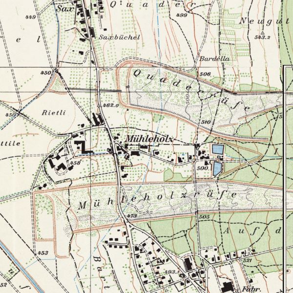
Pixel map Liechtenstein 1:10,000 (1943/1947)
Coloured national map of Liechtenstein at a scale of 1:10,000. The historical map series consists of six sheets with the updates 1943 and 1947. The northern half of the country is covered by two sheets, the southern half by four. As these four sheets overlap to a large extent, only the supplementary sections of sheets 6 and 7 are provided as standard.
Simple
- Date (Creation)
- 1947-01-01
- Identifier
- https://metadata.geo.llv.li/40a7d8a1-a648-44e3-9a9a-5ac950fb8faa
- Purpose
-
Historical map, historical development
- Status
- Obsolete
Publisher
- Hours of service
-
8:00-11:30 und 13:30-17:00
- Spatial representation type
- Grid
Spatial resolution
- Spatial resolution
- 0.5 m
- Topic category
-
- A Imagery base maps earth cover
Extent
Extent
- Description
-
Liechtenstein
))

- Maintenance and update frequency
- Unknown
- geocat.ch
-
-
historic map
-
national map
-
INSPIRE
-
OpenData
-
- GEMET
-
-
historical evolution
-
- GEMET - INSPIRE themes, version 1.0
-
-
Land cover
-
- Räumlicher Anwendungsbereich
-
-
National
-
- geocat.ch
-
-
topography
-
- GEMET
-
-
map chart
-
Resource constraints
- Use limitation
-
No Conditions Apply
- Access constraints
- Other restrictions
- Use constraints
- Other restrictions
- Other constraints
- No limitations to public access
Resource constraints
- Access constraints
- Other restrictions
- Use constraints
- Other restrictions
- Other constraints
- No conditions to access and use
- Other constraints
- Opendata BY: Open use. Must provide the source.
- Language
- Deutsch
- Character encoding
- UTF8
- Subtopic Category
- A1 Base Maps, Landscape Models
- Attribute description
- RGB-Farbwert
- Distribution format
-
-
Tagged Image File Format (TIFF) Compressed LZW
-
Point of contact
- Hours of service
-
8:00-11:30 und 13:30-17:00
Digital transfer options
Digital transfer options
- Units of distribution
-
1 Kartenblatt
- OnLine resource
-
li.abi.pk10_1943
OGC-WMS Service of the National Administration
Digital transfer options
- Units of distribution
-
1 Kartenblatt
- OnLine resource
-
Download als GeoTiff über das Geodatenportal
Download as GeoTiff via the geodata portal
- Hierarchy level
- Dataset
Report
Result
- Title
-
VERORDNUNG (EG) Nr. 1089/2010 DER KOMMISSION vom 23. November 2010 zur Durchführung der Richtlinie 2007/2/EG des Europäischen Parlaments und des Rates hinsichtlich der Interoperabilität von Geodatensätzen und -diensten
- Date (Creation)
- 2010-08-18
- Explanation
-
nicht geprüft
- Pass
- false
- Statement
-
Auswertung aus photogrammetrischer Befliegung
- Hierarchy level
- Dataset
- Number of dimensions
- 2
- Cell geometry
- Area
- Transformation parameter availability
- 1
- Reference system identifier
- http://www.opengis.net/def/crs/EPSG/0/2056
- Maintenance and update frequency
- As needed
Metadata
- Metadata identifier
- 40a7d8a1-a648-44e3-9a9a-5ac950fb8faa
- Language
- Deutsch
- Character encoding
- UTF8
- Language
- Français
- Character encoding
- UTF8
- Language
- Italiano
- Character encoding
- UTF8
- Language
- English
- Character encoding
- UTF8
Point of contact
- Hours of service
-
8:00-11:30 und 13:30-17:00
Type of resource
- Resource scope
- Dataset
- Metadata linkage
-
https://www.geocat.ch/geonetwork/srv/api/records/40a7d8a1-a648-44e3-9a9a-5ac950fb8faa
- Date info (Creation)
- 2010-06-09T09:58:47Z
- Date info (Revision)
- 2026-04-13T09:17:26.303038Z
Metadata standard
- Title
-
eCH-0271