geocat.ch
DHM25
MNT25
DHM25 basis model
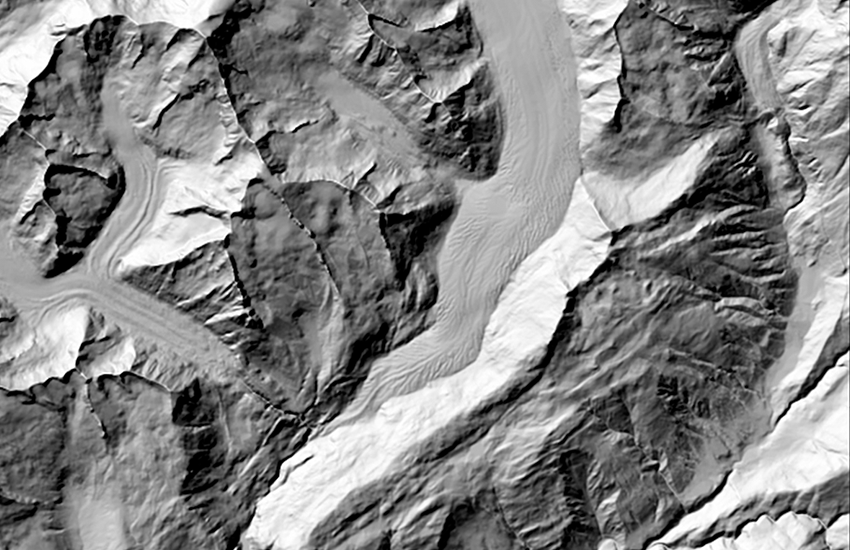
Das digitale Höhenmodell DHM25 ist ein Datensatz, welcher die dreidimensionale Form der Erdoberfläche beschreibt. Er wurde aus der Höheninformation der Landeskarte 1:25'000 und 1:50'000 -nur für den erweiterten Perimeter- abgeleitet. Das Basismodell enthält die folgenden Elementen: lineare Elemente: vektorisierte Höhenkurven und Seebodenkurven, vektorisierte Seekonturen, Hauptbruchkanten im Alpengebiet; punktförmige Elemente:digitalisierte Höhenkoten und Seebodenkoten. Das DHM25 gibt die Form der rohen Erdoberfläche ohne Bewuchs und Bebauung wieder.
Le modèle numérique du terrain MNT25 est un jeu de données qui décrit la surface terrestre en trois dimensions. Il est conçu essentiellement à partir des informations d'altitude tirées de la Carte nationale 1:25'000 et 1:50'000 pour le périmètre élargi. Le modèle de base contient les informations altimétriques numériques suivantes: éléments linéaires: courbes de niveau et courbes des fonds des lacs vectorisées, contours des lacs vectorisés, lignes de crêtes principales en région alpine; éléments ponctuels:cotes d'altitude et cotes de fond des lacs numérisées. Le MNT25 ne fournit que les formes brutes de la surface terrestre, sans végétation ni construction.
The digital height model DHM25 is a data set representing the three-dimensional form of the earth?s surface. It was derived from the height information of the Swiss National Map 1:25'000 and 1:50'000 -for the extended perimeter.The base model contains the following elements: linear elements: vectorized contours and contours in lakes, vectorized lake perimeters, primary breaklines; dot elements: digitized spot heights and depth spot heights in lakes. The DHM25 represents the topography of the earth's surface without vegetation or built up areas.
Simple
-
Date (Révision)Data (Revisione)Date (Revision)Datum (Aktualisierung)
- 2004-01-01T00:00:00
-
IdentifiantIdentificatoreIdentifierKennung
- 41.3
-
ÉtatStatoStatusBearbeitungsstatus
-
TerminéCompletatoCompletedAbgeschlossen
Point de contact
Punto di contatto
Point of contact
Ansprechpartner
Propriétaire
Proprietario
Owner
Eigentümer
-
Type de représentation spatialeTipo di rappresentazione spazialeSpatial representation typeRäumliche Darstellungsart
-
vecteurVettorialeVectorVektor
Résolution spatiale
Risoluzione spaziale
Spatial resolution
Räumliche Auflösung
Fraction représentative
Frazione rappresentativa
Equivalent scale
Vergleichsmassstab
-
DénominateurDenominatoreDenominatorMassstabszahl
- 25000
-
Catégorie de thèmeCategoria ISOTopic categoryThematik
-
-
C ÉlévationC AltitudineC ElevationC Höhenangaben
-
Étendue
Estensione
Extent
Ausdehnung
Étendue
Estensione
Extent
Ausdehnung
-
DescriptionDescrizioneDescriptionBeschreibung
-
DHM25
DHM25
MNT25
MDT25
-
Identifiant géographiqueIdentificatore geograficoGeographic identifierGeografische Kennung
- DHM25DHM25MNT25MDT25
))

-
Fréquence de mise à jourFrequenza di aggiornamentoMaintenance and update frequencyWartungsintervall
-
IrrégulièreIrregolareIrregularUnregelmässig
-
Remarque sur la mise à jourNota sull'aggiornamentoMaintenance noteAnmerkung
-
Der Nachführungsstand der Elemente des Basismodells entspricht demjenigen der Ersterfassung, mit Ausnahme der Gletschergebiete, welche gemäss dem im Winter 2000/2001 verfügbaren Kartenstand nachgeführt sind.
L’état de mise à jour des éléments du modèle de base correspond à celui de la saisie initiale, exception faite des régions des glaciers qui ont été mises à jour sur la base des cartes disponibles en hiver 2000/2001
The status of the DHM25 corresponds to that of the initial capture and digitization of the elements for the basis model except for glacial regions, which were updated in winter 2000/2001.
-
Durée de conservationDurata di conservazioneDuration of ConservationAufbewahrungsdauer NV in Jahren
- 275
-
Évaluation de la valeur archivistiqueValutazione del valore archivisticoAppraisal of Archival ValueBewertung Archivwürdigkeit
-
AAAA
-
Raison de la valeur d'archivageMotivo del valore archivisticoReason for Archiving ValueBegründung Archivwürdigkeit
-
Preuve de la pratique couranteProva della pratica commercialeEvidence of business practiceNachweis der Geschäftspraxis
- geocat.ch
-
-
courbe des fonds des lacs
quota altimetrica dei laghi
contour in lakes
-
cote d'altitude
quota altimetrica
spot height
-
géodonnées de base
geodati di base
official geodata
-
topographie
topografia
topography
-
modèle numérique de terrain MNT
modello digitale del terreno DTM
digital terrain model DTM
-
Planification de la conservation et de l'archivage AAP - Conféderation
Pianificazione della conservazione e dell’archiviazione AAP - Confederazione
Conservation and archiving planning AAP - Confederation
-
isophyse
isofise
isophysis
-
courbe de niveau
curva di livello
contour line
-
géodonnées
geodati
geodata
-
représentation du terrain
rappresentazione del terreno
terrain representation
-
MNA (modèle numérique d'altitude)
DEM (modello digitale di elevazione)
DEM (digital elevation model)
-
ombrage
ombreggiatura
hillshade
-
SIG (Système d'Information Géographique)
SIG (Sistema Informativo Geografico)
GIS (Geographic Information System)
-
visualisation 3D
visualizzazione 3D
3D visualisation
-
opendata.swiss
opendata.swiss
opendata.swiss
-
- GEMET - INSPIRE themes, version 1.0
-
-
Altitude
Elevazione
Elevation
-
- GEMET
-
-
relief
rilievo
relief (land)
-
Contraintes sur la ressource
Vincoli sulle risorse
Resource constraints
Ressourcenbeschränkungen
-
Autres contraintesAltri vincoliOther constraintsAndere Einschränkungen
-
Freie Nutzung. Quellenangabe ist Pflicht.
Utilisation libre. Obligation d’indiquer la source.
Libero utilizzo. Indicazione della fonte obbligatoria.
NonCommercialAllowed-CommercialAllowed-ReferenceRequired
Ressource associée
Risorsa associata
Associated resource
Verlinkte Ressource
-
TitreTitoloTitleTitel
-
Höhendaten (Landesvermessung)
Données altimétriques (mensuration nationale)
Dati altimetrici (misurazione nazionale)
-
Type d'associationTipo di associazioneAssociation TypeAssoziationstyp
-
Citation de travail plus largeCitazione di un'opera più ampiaReference to a master resource of which this one is a partÜbergeordneter Datenbestand
-
LangueLinguaLanguageSprache
- Deutsch
-
Encodage de caractèresCodifica dei caratteriCharacter encodingZeichenkodierung
-
Utf8UTF8UTF8Utf8
-
Informations supplémentairesInformazioni supplementariSupplemental InformationZusätzliche Informationen
-
Aus technischen Gründen konnten in steilen Gebieten nicht alle Höhenkurven geschlossen werden, hingegen wur-de dies für alle 100 m-Kurven sichergestellt. In überhängenden Felswänden sind die unterliegenden Höhenkurven auf jeden Fall offen.
Pour des raisons techniques, il n'a pas été possible de fermer toutes les courbes de niveau en régions escarpées; par contre, il est garanti que toutes les courbes des 100 m sont fermées. Les courbes de niveau situées en des-sous de parois rocheuses surplombantes sont toujours ouvertes.
Due to technical reasons only the index contours (100 m) of the NM25 are digitized in steep terrain. In overhanging cliffs the other contours are omitted.
-
Géodonnées de baseGeodati di baseBasic GeodataGeobasisdaten
- true
-
Identifiant Géodonnées de baseIdentificativo dei geodati di baseBasic Geodata IDIdentifikator des Geobasisdatensatzes
-
41.3
-
Niveau des géodonnées de baseLivello legale dei geodati di baseBasic Geodata Legal LevelGeobasisdatenebene
-
FédéralFederaleFederalNational
-
Type de géodonnées de baseTipo di geodati di baseBasic Geodata TypeGeobasisdatentyp
-
Géodonnées de référenceGeodati di riferimentoReference GeodataGeoreferenzdaten
-
Conformité à ISO 19110Conformità alla norma ISO 19110Compliance codeKonformität mit ISO 19110
- 0
-
LangueLinguaLanguageSprache
- Deutsch
-
LangueLinguaLanguageSprache
- Français
-
Livré avec jeu de donnéesFornito con set di datiIncluded with datasetMit Datensatz geliefert
- 0
-
TitreTitoloTitleTitel
-
DHM25 : Das digitale Höhenmodell der Schweiz. Produktinfo.
MNT25, le modèle numérique de terrain de la Suisse. Information de produit.
-
Date (Révision)Data (Revisione)Date (Revision)Datum (Aktualisierung)
- 2004-06-01
-
Autres informations de référenceAltre informazioni di riferimentoOther citation detailsWeitere Referenzinformationen
-
Format de distributionFormato (codifica)Distribution formatAbgabeformat
-
-
AutoCAD DXF (DXF)
-
ESRI Shapefile (SHP)
-
Options de transfert numérique
Opzioni di trasferimento digitale
Digital transfer options
Optionen für die digitale Übertragung
-
Ressource en ligneRisorsa onlineOnLine resourceOnline
-
MNT25
Options de transfert numérique
Opzioni di trasferimento digitale
Digital transfer options
Optionen für die digitale Übertragung
-
Ressource en ligneRisorsa onlineOnLine resourceOnline
-
map.geo.admin.ch
Options de transfert numérique
Opzioni di trasferimento digitale
Digital transfer options
Optionen für die digitale Übertragung
Options de transfert numérique
Opzioni di trasferimento digitale
Digital transfer options
Optionen für die digitale Übertragung
-
Ressource en ligneRisorsa onlineOnLine resourceOnline
-
Permalink opendata.swiss
Permalink opendata.swissPermalink opendata.swissPermalink opendata.swissPermalink opendata.swiss
-
Généralités sur la provenanceInformazioni generali sulla provenienzaStatementErklärung
-
aus der Höheninformation der Landeskarte 1:25'000 abgeleitet, der Landeskarte 1:50'000 im erweiterten Perimeter.
Se base sur les informations d'altitude de la Carte nationale 1:25'000 et de la Carte nationale 1:50'000 pour le périmètre élargi.
derived from the elevation information of the National map 1:25'000, of the National map 1:50'000 for the extended perimeter.
-
NiveauLivelloHierarchy levelBezugsebene
-
Jeu de donnéesSet di datiDatasetDatenbestand
-
Niveau de topologieLivello di topologiaTopology levelTopologieebene
-
Topologie de réseauTopologia 1DTopology 1DNetzwerktopologie
-
Type d’objet géométriqueTipo di oggetto geometricoGeometric object typeTyp des geometrischen Objekts
-
LigneCurvaCurvecurve
-
Nombre d’objets géométriquesNumero di oggetti geometriciGeometric object countAnzahl geometrischer Objekte
- 525087
-
Type d’objet géométriqueTipo di oggetto geometricoGeometric object typeTyp des geometrischen Objekts
-
PointPuntoPointpoint
-
Nombre d’objets géométriquesNumero di oggetti geometriciGeometric object countAnzahl geometrischer Objekte
- 209505
-
Nom du système de référenceNome del sistema di riferimentoReference system identifierName des Referenzsystems
- EPSG:21781
-
Nom du système de référenceNome del sistema di riferimentoReference system identifierName des Referenzsystems
- EPSG:5728
-
Fréquence de mise à jourFrequenza di aggiornamentoMaintenance and update frequencyWartungsintervall
-
Comme nécessaireSecondo necessitàAs neededBei Bedarf
Metadata
-
Identifiant des métadonnéesIdentificativo della schedaMetadata identifierIdentifikator des Metadatensatzes
- 3fab2ac3-4271-46b2-823e-ab4814c59d36
-
LangueLinguaLanguageSprache
- Deutsch
-
Encodage de caractèresCodifica dei caratteriCharacter encodingZeichenkodierung
-
Utf8UTF8UTF8Utf8
-
LangueLinguaLanguageSprache
- Français
-
Encodage de caractèresCodifica dei caratteriCharacter encodingZeichenkodierung
-
Utf8UTF8UTF8Utf8
-
LangueLinguaLanguageSprache
- Italiano
-
Encodage de caractèresCodifica dei caratteriCharacter encodingZeichenkodierung
-
Utf8UTF8UTF8Utf8
-
LangueLinguaLanguageSprache
- English
-
Encodage de caractèresCodifica dei caratteriCharacter encodingZeichenkodierung
-
Utf8UTF8UTF8Utf8
Point de contact
Punto di contatto
Point of contact
Ansprechpartner
-
Heures de serviceOrario di servizioHours of serviceBetriebszeiten
-
08h30 - 11h00 / 14h00 - 16h00 GMT+1
Type de ressource
Tipo di risorsa
Type of resource
Anwendungsbereich der Metadaten
-
Domaine d'application de la ressourceAmbito di applicazione della risorsaResource scopeDomäne der Ressourcenanwendung
-
Jeu de donnéesSet di datiDatasetDatenbestand
-
Informations de date (Création)Informazioni sulla data (Creazione)Date info (Creation)Datumsangaben (Erstellung)
- 2009-01-28T12:00:00Z
-
Informations de date (Révision)Informazioni sulla data (Revisione)Date info (Revision)Datumsangaben (Aktualisierung)
- 2026-04-13T09:17:21.12046Z
Norme des métadonnées
Standard dei metadati
Metadata standard
Metadatenstandard
-
TitreTitoloTitleTitel
-
eCH-0271