geocat.ch
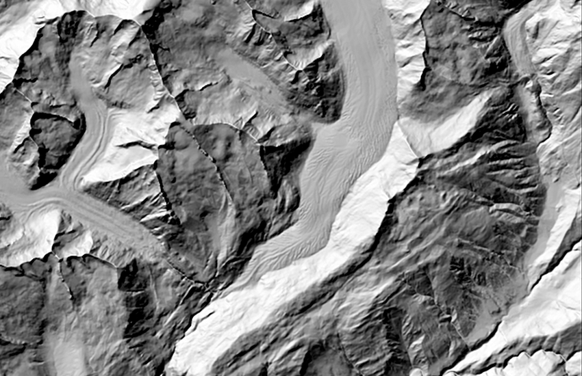
DHM25 basis model
The digital height model DHM25 is a data set representing the three-dimensional form of the earth?s surface. It was derived from the height information of the Swiss National Map 1:25'000 and 1:50'000 -for the extended perimeter.The base model contains the following elements: linear elements: vectorized contours and contours in lakes, vectorized lake perimeters, primary breaklines; dot elements: digitized spot heights and depth spot heights in lakes. The DHM25 represents the topography of the earth's surface without vegetation or built up areas.
Simple
- Date (Revision)
- 2004-01-01T00:00:00
- Identifier
- 41.3
- Status
- Completed
Point of contact
Owner
- Spatial representation type
- Vector
Spatial resolution
Equivalent scale
- Denominator
- 25000
- Topic category
-
- C Elevation
Extent
Extent
- Description
-
DHM25
- Geographic identifier
- DHM25
))

- Maintenance and update frequency
- Irregular
- Maintenance note
-
The status of the DHM25 corresponds to that of the initial capture and digitization of the elements for the basis model except for glacial regions, which were updated in winter 2000/2001.
- Duration of Conservation
- 275
- Appraisal of Archival Value
- A
- Reason for Archiving Value
- Evidence of business practice
- geocat.ch
-
-
contour in lakes
-
spot height
-
official geodata
-
topography
-
digital terrain model DTM
-
Conservation and archiving planning AAP - Confederation
-
isophysis
-
contour line
-
geodata
-
terrain representation
-
DEM (digital elevation model)
-
hillshade
-
GIS (Geographic Information System)
-
3D visualisation
-
opendata.swiss
-
- GEMET - INSPIRE themes, version 1.0
-
-
Elevation
-
- GEMET
-
-
relief (land)
-
Resource constraints
- Other constraints
-
NonCommercialAllowed-CommercialAllowed-ReferenceRequired
Associated resource
- Title
-
Höhendaten (Landesvermessung)
- Association Type
- Reference to a master resource of which this one is a part
- Language
- Deutsch
- Character encoding
- UTF8
- Supplemental Information
-
Due to technical reasons only the index contours (100 m) of the NM25 are digitized in steep terrain. In overhanging cliffs the other contours are omitted.
- Basic Geodata
- true
- Basic Geodata ID
-
41.3
- Basic Geodata Legal Level
- Federal
- Basic Geodata Type
- Reference Geodata
- Compliance code
- 0
- Language
- Deutsch
- Language
- Français
- Included with dataset
- 0
- Title
-
DHM25 : Das digitale Höhenmodell der Schweiz. Produktinfo.
- Date (Revision)
- 2004-06-01
- Distribution format
-
-
AutoCAD DXF (DXF)
-
ESRI Shapefile (SHP)
-
Digital transfer options
- OnLine resource
-
MNT25
Digital transfer options
- OnLine resource
-
map.geo.admin.ch
Digital transfer options
- OnLine resource
-
Permalink opendata.swiss
Permalink opendata.swiss
- Statement
-
derived from the elevation information of the National map 1:25'000, of the National map 1:50'000 for the extended perimeter.
- Hierarchy level
- Dataset
- Topology level
- Topology 1D
- Geometric object type
- Curve
- Geometric object count
- 525087
- Geometric object type
- Point
- Geometric object count
- 209505
- Reference system identifier
- EPSG:21781
- Reference system identifier
- EPSG:5728
- Maintenance and update frequency
- As needed
Metadata
- Metadata identifier
- 3fab2ac3-4271-46b2-823e-ab4814c59d36
- Language
- Deutsch
- Character encoding
- UTF8
- Language
- Français
- Character encoding
- UTF8
- Language
- Italiano
- Character encoding
- UTF8
- Language
- English
- Character encoding
- UTF8
Point of contact
Type of resource
- Resource scope
- Dataset
- Metadata linkage
-
https://www.geocat.ch/geonetwork/srv/api/records/3fab2ac3-4271-46b2-823e-ab4814c59d36
- Date info (Creation)
- 2009-01-28T12:00:00Z
- Date info (Revision)
- 2026-04-13T09:17:21.12046Z
Metadata standard
- Title
-
eCH-0271