geocat.ch
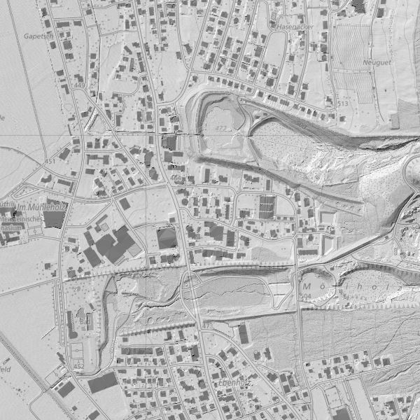
Digital Elevation Model (DTM 2015)
Digitales Terrainmodell über ganz Liechtenstein als Grid 0.5m, ohne Bruchkanten. Erstellt am 8. April 2015 (Talgebiet) und am 26. August 2015 (Berggebiet nach Schneefreiheit) von der Firma TopScan GmbH mit Laserscannermessung aus einer Cessna 402 B und einer mittl. Flughöhe von 800 m. Die Höhengenauigkeit (einfache Standardabweichung) des Terrainmodells beträgt ±0.2 m, die Punktdichte 4 Punkte pro Quadratmeter. Die Gemeinden des Landes haben sich an den Herstellungskosten beteiligt (keine Nutzungsgebühr bei Bezug).
Simple
- Date (Creation)
- 2016-02-17
- Identifier
- https://metadata.geo.llv.li/3a1af678-01fa-4069-bc83-d17627725ef4
- Purpose
-
Basisdaten, Höheninformation für einen präzise Beschreibung des Geländes.
- Status
- Completed
Point of contact
- Hours of service
-
8:00-11:30 und 13:30-17:00
- Spatial representation type
- Vector
- Topic category
-
- C Elevation
- C Elevation
Extent
Extent
- Description
-
Liechtenstein
))

- Maintenance and update frequency
- Unknown
Resource format
- Title
-
Erdas Imagine (IMG)
- Date
- Edition
-
unknown
Resource format
- Title
-
ASPRS LASer (LAS)
- Date
- geocat.ch
-
-
INSPIRE
-
digital terrain model DTM
-
LIDAR (Light Detection And Ranging)
-
terrain representation
-
- GEMET - INSPIRE themes, version 1.0
-
-
Elevation
-
- GEMET
-
-
altitude
-
- Räumlicher Anwendungsbereich
-
-
National
-
Resource constraints
- Access constraints
- Other restrictions
- Other constraints
- no limitations to public access
- Country
- LI
- Legislation Type
- Ordinance
- Legislation Level
- national
- Title
-
Verordnung über die Gebühren für die Nutzung der Geodateninfrastruktur Liechtenstein
- Alternate title
-
GDI-Gebührenverordnung (GDI-GebV)
- Date (Creation)
- 2011-08-30
Resource constraints
- Use limitation
-
Zugangs- und Nutzungsbedingungen
- Use constraints
- Other restrictions
- Other constraints
-
lizenzfplichtig
- Language
- Deutsch
- Character encoding
- UTF8
- Included with dataset
- 0
- Title
-
Digitales Höhenmodell (DHM)
- Date (Revision)
- 2016-02-17
- Distribution format
-
-
GRID ASCII (XYZ)
-
GeoTIFF (GEOTIFF)
-
ESRI Arcinfo ASCII GRID (ASC)
-
AutoCAD DXF (DXF)
-
Point of contact
- Hours of service
-
8:00-11:30 und 13:30-17:00
Digital transfer options
- OnLine resource
-
Geodatenportal
Geodatenportal der Liecht. Landesverwaltung
Digital transfer options
- OnLine resource
-
EL
INSPIRE View Service
Digital transfer options
- OnLine resource
-
INSPIRE Download Service (ATOM)
GML Download
Digital transfer options
- OnLine resource
-
EL.GridCoverage
INSPIRE OGS WCS Service
- Hierarchy level
- Dataset
- Other
-
alle Ebenen
Report
Result
- Title
-
Commission Regulation (EU) No 1089/2010 of 23 November 2010 implementing Directive 2007/2/EC of the European Parliament and of the Council as regards interoperability of spatial data sets and services
- Date (Publication)
- 2010-12-08
- Explanation
-
INSPIRE Konformität
- Pass
- true
- Statement
-
Lascerscanning
- Hierarchy level
- Dataset
- Other
-
alle Ebenen
- Reference system identifier
- http://www.opengis.net/def/crs/EPSG/0/2056
- Reference system identifier
- http://www.opengis.net/def/crs/EPSG/0/21782
- Reference system identifier
- http://www.opengis.net/def/crs/EPSG/0/4936
- Maintenance and update frequency
- As needed
Metadata
- Metadata identifier
- 3a1af678-01fa-4069-bc83-d17627725ef4
- Language
- Deutsch
- Character encoding
- UTF8
- Language
- Français
- Character encoding
- UTF8
- Language
- Italiano
- Character encoding
- UTF8
- Language
- English
- Character encoding
- UTF8
Point of contact
- Hours of service
-
8:00-11:30 und 13:30-17:00
Type of resource
- Resource scope
- Dataset
- Metadata linkage
-
https://www.geocat.ch/geonetwork/srv/api/records/3a1af678-01fa-4069-bc83-d17627725ef4
- Date info (Creation)
- 2016-08-03T14:22:56Z
- Date info (Revision)
- 2026-05-05T12:36:17.041048Z
Metadata standard
- Title
-
eCH-0271