geocat.ch
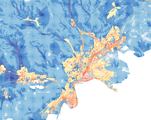
Klimakarten Kanton Schaffhausen
Die Klimakarten umfassen folgende Datensätze (Vektordaten und Rasterdaten mit eine Auflösung von 10x10 m):
• Den Output der FITNAH3D-Modellierung für die Tag- (14:00) und Nachtsituation (04:00) der Klimamodell-Karte. Der Datensatz enthält Angaben zu Temperatur und Wind.
• Die Klimaanalysekarte
• Die Planhinweiskarte für die Tag- und Nachtsituation
• Sensible Orte für die Planung von Klimamassnahmen (Kinderkrippen, Altersheime, Spitäler, Spielplätze, etc.)
• Landnutzungsdaten, die zur Erstellung der Klimamodellierung verwendet wurden
Simple
- Date (Revision)
- 2024-11-20
- Date (Creation)
- 2024-03-26
- Status
- On going
Point of contact
Owner
- Topic category
-
- K Climatology, meteorology, atmosphere
Extent
Extent
- Description
-
Kanton Schaffhausen
))

- Maintenance and update frequency
- Not planned
- Duration of Conservation
- 0
- Comment on Duration of Conservation
-
Aufbewahrungsfrist unbekannt.
- Appraisal of Archival Value
- A
- Reason for Archiving Value
- Evidence of business practice
- Keywords
-
-
Klima
-
Meteorologie
-
Kaltluft
-
Hitze
-
Klimaentwicklung
-
Klimawandel
-
Raumplanung
-
opendata.swiss
-
Siedlung
-
Umweltbeobachtung
-
Resource constraints
- Other constraints
- Freie Nutzung
Associated resource
- Association Type
- Reference to a master resource of which this one is a part
- Language
- Deutsch
- Character encoding
- UTF8
- Subtopic Category
- E1 Spatial Planning, Spatial Development
- Subtopic Category
- L1 Environmental Protection, Noise
- Basic Geodata
- false
- Basic Geodata Type
- openGovernmentData
- Distribution format
-
-
DXF/DWG
-
WMS Dienst
-
WFS Dienst
-
ESRI Shapefile
-
Geopackage
-
GeoTIFF
-
Distributor
Digital transfer options
- OnLine resource
-
Kanton Schaffhausen
Kanton Schaffhausen
Digital transfer options
- OnLine resource
-
Kanton Schaffhausen
Kanton Schaffhausen
Digital transfer options
- OnLine resource
-
Kanton Schaffhausen
Kanton Schaffhausen
Digital transfer options
- OnLine resource
-
(GeoPackage, DXF, Shapefile, GeoTIFF)
(GeoPackage, DXF, Shapefile, GeoTIFF)
- Reference system identifier
- 2056
- Maintenance and update frequency
- Not planned
Metadata
- Metadata identifier
- 2f81947a-b68f-45a3-a9ca-872dd865955b
- Language
- Deutsch
- Character encoding
- UTF8
Point of contact
Type of resource
- Resource scope
- Dataset
- Metadata linkage
-
https://www.geocat.ch/geonetwork/srv/api/records/2f81947a-b68f-45a3-a9ca-872dd865955b
- Date info (Creation)
- 2024-03-27T10:34:27Z
- Date info (Revision)
- 2026-04-13T09:26:23.038475Z
Metadata standard
- Title
-
GM03 2+