geocat.ch
Geothermische Karte der Schweiz 1:500000
Carte géothermique de la Suisse 1:500000
Carta geotermica svizzera 1:500000
Geothermal Map of Switzerland 1:500000
Charta geotermica da la Svizra 1:500000
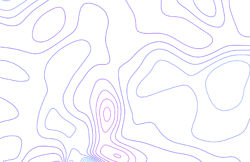
Die geothermische Karte zeigt die Wärmeenergie, die im Untergrund produziert wird und die durch 1 m2 an die Erdoberfläche strömt (mW/m2). Die Wärmefluss-Daten werden aus Temperaturgradient (Mittelwert ca. 30 K/km) und Wärmeleitfähigkeit der Gesteine (Mittelwert ca. 3 W/(m·K) berechnet. Die Wärme selbst wird grösstenteils in der Erdkruste (ca. 30 km mächtig) durch radioaktive Zerfallsprozesse freigesetzt. Im Mittel beträgt der Wärmefluss in der Schweiz rund 90 mW/m2. Die Nordschweiz hat die höchsten Werte und der Alpenraum/Jura hat die tiefsten Werte. Abweichungen vom regionalen Wärmeflusstrend können ein Hinweis auf zirkulierende Tiefenwässer in durchlässigen Gesteinsschichten sein. - Quelle: <a href=" https://www.geocat.ch/geonetwork/srv/api/records/2d8174b2-8c4a-44ea-b470-cb3f216b90d1/attachments/Beitrag_GP_030_Medici-Rybach.pdf?approved=true" target="_blank">F. MEDICI & L. RYBACH, Geothermal map of Switzerland 1995 (heat flow density), Beiträge zur Geologie der Schweiz, Serie Geophysik, Nr. GP-30</a>.
La carte géothermique rend compte de l'énergie thermique produite dans le sous-sol qui traverse 1 m2 de surface terrestre (mW/m2). Les valeurs du flux de chaleur sont calculées à partir du gradient thermique (en moyenne environ 30 K/km) et de la conductivité thermique des roches (en moyenne environ 3 W/(m·K). Une grande partie de la chaleur est libérée par des processus de désintégration radioactive qui se déroulent dans la croûte terrestre (environ 30 km). En Suisse, le flux de chaleur moyen est d’environ 90 mW/m2. Le flux de chaleur est le plus élevé dans le nord de la Suisse, et il est le plus faible dans l'arc alpin et dans le Jura. Les écarts sont généralement dus à des eaux souterraines qui circulent en profondeur dans des roches perméables. - Source: <a href=" https://www.geocat.ch/geonetwork/srv/api/records/2d8174b2-8c4a-44ea-b470-cb3f216b90d1/attachments/Beitrag_GP_030_Medici-Rybach.pdf?approved=true" target="_blank">F. MEDICI & L. RYBACH, Geothermal map of Switzerland 1995 (heat flow density), Matériaux pour la Géologie de la Suisse, Série géophysique, no. GP-30</a>.
La carta geotermica indica l'energia termica prodotta nel sottosuolo che attraversa 1 m2 di superficie terrestre (mW/m2). I valori del flusso di calore vengono calcolati in base al gradiente termico (in media circa 30 K/km) e alla conduttività termica delle rocce (in media circa 3 W/(m·K). Il calore stesso viene liberato in buona parte nella crosta terrestre (spessa circa 30 km) attraverso un processo di disintegrazione radioattiva. In media il flusso di calore ammonta in Svizzera a circa 90 mW/m2. La Svizzera settentrionale presenta i valori più elevati, le regioni delle Alpi e del Giura quelli più bassi. Gli scarti sono dovuti generalmente alla circolazione di flussi di acqua sotterranea attraverso strati di roccia permeabili. - Fonte: <a href=" https://www.geocat.ch/geonetwork/srv/api/records/2d8174b2-8c4a-44ea-b470-cb3f216b90d1/attachments/Beitrag_GP_030_Medici-Rybach.pdf?approved=true" target="_blank">F. MEDICI & L. RYBACH, Geothermal map of Switzerland 1995 (heat flow density), Contributi relativi alla geologia della Svizzera, Serie geofisica, n. GP-30</a>.
The geothermal map shows the thermal energy that is produced in the subsurface and traverses the Earth's surface within an area of 1 m2 (mW/m2). The heat flow data is calculated from the temperature gradient (average value approx. 30 K/km) and heat conductivity of the rock (average value approx. 3 W/(m·K). The heat itself is released in the Earth's crust (ca. 30 km thick) generally by radioactive decay processes. On average, the heat flow in Switzerland is around 90 mW/m2. The highest figures are found in northern Switzerland and the lowest in the Alps/Jura. Differences are caused by deep groundwater circulating in permeable rock strata. - Source: <a href=" https://www.geocat.ch/geonetwork/srv/api/records/2d8174b2-8c4a-44ea-b470-cb3f216b90d1/attachments/Beitrag_GP_030_Medici-Rybach.pdf?approved=true" target="_blank">F. MEDICI & L. RYBACH, Geothermal map of Switzerland 1995 (heat flow density), Contributions to the Geology of Switzerland, Geophysical Series, No. GP-30</a>.
Simple
-
Autre titreAltri nomi o acronimiAlternate titleAlternate titleAlternativtitel
-
Wärmestromdichte 500
Densité de flux thermique 500
Densità di flusso termico 500
Heat flux 500
Densitad dal fluss da chalur 500
-
Date (Publication)Data (Pubblicazione)Date (Publication)Date (Publication)Datum (Publikation)
- 1982-12-31
-
IdentifiantIdentificatoreIdentifierIdentifierKennung
- ch.swisstopo.geologie-geophysik-geothermie
-
Autres informations de référenceAltre informazioni di riferimentoOther citation detailsOther citation detailsWeitere Referenzinformationen
-
Siehe auch Publikation Nr. 30 der Schweizerischen Geophysikalischen Kommission.
Voir aussi Publication No 30 de la Commission suisse de géophysique.
-
ButScopoPurposePurposeZweck
-
Übersicht über die Geothermie in der Schweiz
Vue d’ensemble de la géothermie en Suisse
-
ÉtatStatoStatusStatusBearbeitungsstatus
-
TerminéCompletatoCompletedCompletedAbgeschlossen
Propriétaire
Proprietario
Owner
Owner
Eigentümer
-
Type de représentation spatialeTipo di rappresentazione spazialeSpatial representation typeSpatial representation typeRäumliche Darstellungsart
-
vecteurVettorialeVectorVectorVektor
Résolution spatiale
Risoluzione spaziale
Spatial resolution
Spatial resolution
Räumliche Auflösung
Fraction représentative
Frazione rappresentativa
Equivalent scale
Equivalent scale
Vergleichsmassstab
-
DénominateurDenominatoreDenominatorDenominatorMassstabszahl
- 500000
-
Catégorie de thèmeCategoria ISOTopic categoryTopic categoryThematik
-
-
F Informations géoscientifiquesF Informazioni geoscientificheF Geoscientific informationF Geoscientific informationF Erdwissenschaften
-
Étendue
Estensione
Extent
Extent
Ausdehnung
Étendue
Estensione
Extent
Extent
Ausdehnung
-
DescriptionDescrizioneDescriptionDescriptionBeschreibung
-
National Map 1:500'000
Landeskarte 1:500'000
Carte nationale 1:500'000
Carta nazionale 1:500'000
Landeskarte 1:500'000
-
Identifiant géographiqueIdentificatore geograficoGeographic identifierGeographic identifierGeografische Kennung
- NM500LK500CN500CN500LK500
))

-
Fréquence de mise à jourFrequenza di aggiornamentoMaintenance and update frequencyMaintenance and update frequencyWartungsintervall
-
IrrégulièreIrregolareIrregularIrregularUnregelmässig
-
Durée de conservationDurata di conservazioneDuration of ConservationDuration of ConservationAufbewahrungsdauer NV in Jahren
- 275
-
Évaluation de la valeur archivistiqueValutazione del valore archivisticoAppraisal of Archival ValueAppraisal of Archival ValueBewertung Archivwürdigkeit
-
AAAAA
-
Raison de la valeur d'archivageMotivo del valore archivisticoReason for Archiving ValueReason for Archiving ValueBegründung Archivwürdigkeit
-
Preuve de la pratique couranteProva della pratica commercialeEvidence of business practiceEvidence of business practiceNachweis der Geschäftspraxis
- geocat.ch
-
-
EGIP (European Geothermal Information Platform)
EGIP (European Geothermal Information Platform)
EGIP (European Geothermal Information Platform)
-
opendata.swiss
opendata.swiss
opendata.swiss
opendata.swiss
-
géodonnées de base
geodati di base
official geodata
-
Planification de la conservation et de l'archivage AAP - Conféderation
Pianificazione della conservazione e dell’archiviazione AAP - Confederazione
Conservation and archiving planning AAP - Confederation
-
e-geo.ch
e-geo.ch
e-geo.ch
-
carte géophysique
carta geofisica
geophysical map
-
- GEMET
-
-
énergie géothermique
energia geotermica
geothermal energy
-
géophysique
geofisica
geophysics
-
- GEMET - INSPIRE themes, version 1.0
-
-
Sources d'énergie
Risorse energetiche
Energy resources
-
Géologie
Geologia
Geology
-
- geocat.ch
-
-
BGDI Bundesgeodaten-Infrastruktur
IFDG l’Infrastructure Fédérale de données géographiques
IFDG Infrastruttura federale dei dati geografici
FSDI Federal Spatial Data Infrastructure
-
Ressource associée
Risorsa associata
Associated resource
Associated resource
Verlinkte Ressource
-
TitreTitoloTitleTitleTitel
-
Geophysikalisches Kartenwerk
Cartes géophysiques
Carte geofisiche
Geophysical maps
-
Type d'associationTipo di associazioneAssociation TypeAssociation TypeAssoziationstyp
-
Citation de travail plus largeCitazione di un'opera più ampiaReference to a master resource of which this one is a partReference to a master resource of which this one is a partÜbergeordneter Datenbestand
-
LangueLinguaLanguageLanguageSprache
- Deutsch
-
Encodage de caractèresCodifica dei caratteriCharacter encodingCharacter encodingZeichenkodierung
-
Utf8UTF8UTF8UTF8Utf8
-
LangueLinguaLanguageLanguageSprache
- Français
-
Encodage de caractèresCodifica dei caratteriCharacter encodingCharacter encodingZeichenkodierung
-
Utf8UTF8UTF8UTF8Utf8
-
LangueLinguaLanguageLanguageSprache
- Italiano
-
Encodage de caractèresCodifica dei caratteriCharacter encodingCharacter encodingZeichenkodierung
-
Utf8UTF8UTF8UTF8Utf8
-
LangueLinguaLanguageLanguageSprache
- English
-
Encodage de caractèresCodifica dei caratteriCharacter encodingCharacter encodingZeichenkodierung
-
Utf8UTF8UTF8UTF8Utf8
-
Catégorie de sous-thèmeCategoria di sottotemaSubtopic CategorySubtopic CategoryThematische Unterkategorien
-
F1 GéologieF1 GeologiaF1 GeologyF1 GeologyF1 Geologie
-
Géodonnées de baseGeodati di baseBasic GeodataBasic GeodataGeobasisdaten
- true
-
Identifiant Géodonnées de baseIdentificativo dei geodati di baseBasic Geodata IDBasic Geodata IDIdentifikator des Geobasisdatensatzes
-
47.10
-
Niveau des géodonnées de baseLivello legale dei geodati di baseBasic Geodata Legal LevelBasic Geodata Legal LevelGeobasisdatenebene
-
FédéralFederaleFederalFederalNational
-
Format de distributionFormato (codifica)Distribution formatDistribution formatAbgabeformat
-
-
ESRI Shapefile (SHP)
-
Options de transfert numérique
Opzioni di trasferimento digitale
Digital transfer options
Digital transfer options
Optionen für die digitale Übertragung
-
Ressource en ligneRisorsa onlineOnLine resourceOnLine resourceOnline
-
Vorschau map.geo.admin.ch
Vorschau map.geo.admin.chAperçu map.geo.admin.chPrevisione map.geo.admin.chPreview map.geo.admin.ch
Options de transfert numérique
Opzioni di trasferimento digitale
Digital transfer options
Digital transfer options
Optionen für die digitale Übertragung
-
Ressource en ligneRisorsa onlineOnLine resourceOnLine resourceOnline
-
ch.swisstopo.geologie-geophysik-geothermie
WMS-BGDI Dienst, Layer "Wärmestromdichte 500"Service WMS-IFDG, couche "Densité de flux thermique 500"Servizio WMS-IFDG, strato "Densità di flusso termico 500"WMS-FSDI service, layer "Heat flux 500"WMS-BGDI Dienst, Layer "Wärmestromdichte 500"
Options de transfert numérique
Opzioni di trasferimento digitale
Digital transfer options
Digital transfer options
Optionen für die digitale Übertragung
-
Ressource en ligneRisorsa onlineOnLine resourceOnLine resourceOnline
-
ch.swisstopo.geologie-geophysik-geothermie
WMTS-BGDI Dienst, Layer "Wärmestromdichte 500"Service WMTS-IFDG, couche , Layer "Densité de flux thermique 500"Servizio WMTS-IFDG, strato "Densità di flusso termico 500"WMTS-FSDI service, layer "Heat flux 500"WMTS-BGDI Dienst, Layer "Wärmestromdichte 500"
Options de transfert numérique
Opzioni di trasferimento digitale
Digital transfer options
Digital transfer options
Optionen für die digitale Übertragung
-
Ressource en ligneRisorsa onlineOnLine resourceOnLine resourceOnline
-
Produkte- und Bestellinformationen
Options de transfert numérique
Opzioni di trasferimento digitale
Digital transfer options
Digital transfer options
Optionen für die digitale Übertragung
-
Ressource en ligneRisorsa onlineOnLine resourceOnLine resourceOnline
-
Download (data.geo.admin.ch)
Options de transfert numérique
Opzioni di trasferimento digitale
Digital transfer options
Digital transfer options
Optionen für die digitale Übertragung
-
Ressource en ligneRisorsa onlineOnLine resourceOnLine resourceOnline
-
Thema Geothermie (map.geo.admin.ch)
Options de transfert numérique
Opzioni di trasferimento digitale
Digital transfer options
Digital transfer options
Optionen für die digitale Übertragung
-
Ressource en ligneRisorsa onlineOnLine resourceOnLine resourceOnline
-
Schweiz. Geophysikalische Kommission SGPK
Options de transfert numérique
Opzioni di trasferimento digitale
Digital transfer options
Digital transfer options
Optionen für die digitale Übertragung
-
Ressource en ligneRisorsa onlineOnLine resourceOnLine resourceOnline
-
RESTful API von geo.admin.ch
RESTful API von geo.admin.chRESTful API de geo.admin.chRESTful API da geo.admin.chRESTful API from geo.admin.chRESTful API dad geo.admin.ch
-
Généralités sur la provenanceInformazioni generali sulla provenienzaStatementStatementErklärung
-
Diese Karte stellt vor dem Hintergrund der Landeskarte 1:500'000 und der Tektonischen Karte 1:500'000 die terrestrische Wärmeenergie dar.
Cette carte représente l'énergie calorifique terrestre sur le fond de la Carte nationale 1:500’000 et de la Carte tectonique 1:500’000.
-
NiveauLivelloHierarchy levelHierarchy levelBezugsebene
-
Jeu de donnéesSet di datiDatasetDatasetDatenbestand
-
Nom du système de référenceNome del sistema di riferimentoReference system identifierReference system identifierName des Referenzsystems
- Referenzsystem entsprechend der zugrundeliegenden topographischen Karte (CH1903)
Metadata
-
Identifiant des métadonnéesIdentificativo della schedaMetadata identifierMetadata identifierIdentifikator des Metadatensatzes
- 2d8174b2-8c4a-44ea-b470-cb3f216b90d1
-
LangueLinguaLanguageLanguageSprache
- Deutsch
-
Encodage de caractèresCodifica dei caratteriCharacter encodingCharacter encodingZeichenkodierung
-
Utf8UTF8UTF8UTF8Utf8
-
LangueLinguaLanguageLanguageSprache
- Français
-
Encodage de caractèresCodifica dei caratteriCharacter encodingCharacter encodingZeichenkodierung
-
Utf8UTF8UTF8UTF8Utf8
-
LangueLinguaLanguageLanguageSprache
- Italiano
-
Encodage de caractèresCodifica dei caratteriCharacter encodingCharacter encodingZeichenkodierung
-
Utf8UTF8UTF8UTF8Utf8
-
LangueLinguaLanguageLanguageSprache
- English
-
Encodage de caractèresCodifica dei caratteriCharacter encodingCharacter encodingZeichenkodierung
-
Utf8UTF8UTF8UTF8Utf8
-
LangueLinguaLanguageLanguageSprache
- Rumantsch
-
Encodage de caractèresCodifica dei caratteriCharacter encodingCharacter encodingZeichenkodierung
-
Utf8UTF8UTF8UTF8Utf8
Propriétaire
Proprietario
Owner
Owner
Eigentümer
Type de ressource
Tipo di risorsa
Type of resource
Type of resource
Anwendungsbereich der Metadaten
-
Domaine d'application de la ressourceAmbito di applicazione della risorsaResource scopeResource scopeDomäne der Ressourcenanwendung
-
Jeu de donnéesSet di datiDatasetDatasetDatenbestand
-
Lien vers la métadonnéeCollegamento ai metadatiMetadata linkageMetadata linkageLink zu den Metadaten
-
Informations de date (Création)Informazioni sulla data (Creazione)Date info (Creation)Date info (Creation)Datumsangaben (Erstellung)
- 2010-04-20T16:02:02Z
-
Informations de date (Révision)Informazioni sulla data (Revisione)Date info (Revision)Date info (Revision)Datumsangaben (Aktualisierung)
- 2026-04-13T09:42:16.290378Z
Norme des métadonnées
Standard dei metadati
Metadata standard
Metadata standard
Metadatenstandard
-
TitreTitoloTitleTitleTitel
-
eCH-0271