geocat.ch
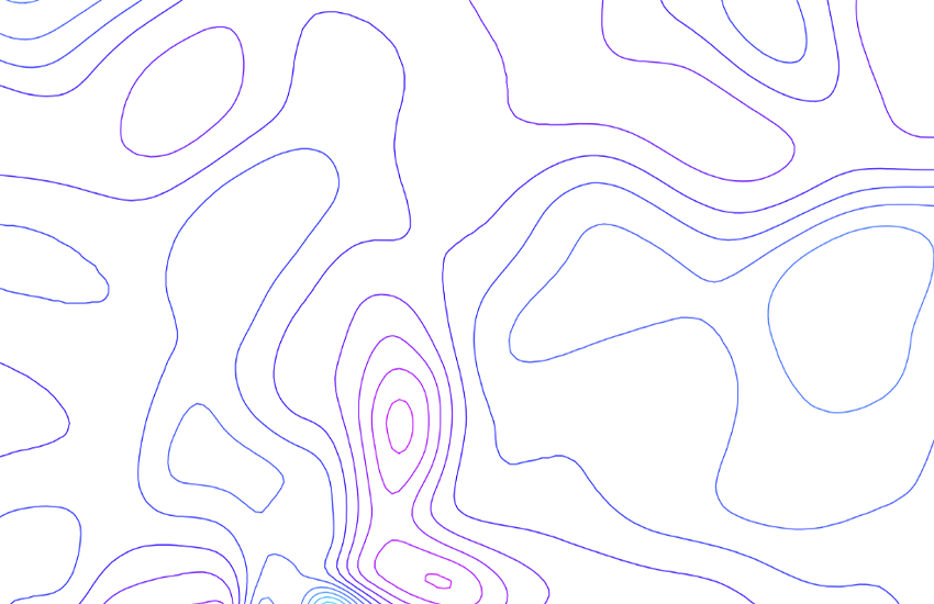
Geothermal Map of Switzerland 1:500000
The geothermal map shows the thermal energy that is produced in the subsurface and traverses the Earth's surface within an area of 1 m2 (mW/m2). The heat flow data is calculated from the temperature gradient (average value approx. 30 K/km) and heat conductivity of the rock (average value approx. 3 W/(m·K). The heat itself is released in the Earth's crust (ca. 30 km thick) generally by radioactive decay processes. On average, the heat flow in Switzerland is around 90 mW/m2. The highest figures are found in northern Switzerland and the lowest in the Alps/Jura. Differences are caused by deep groundwater circulating in permeable rock strata. - Source: <a href=" https://www.geocat.ch/geonetwork/srv/api/records/2d8174b2-8c4a-44ea-b470-cb3f216b90d1/attachments/Beitrag_GP_030_Medici-Rybach.pdf?approved=true" target="_blank">F. MEDICI & L. RYBACH, Geothermal map of Switzerland 1995 (heat flow density), Contributions to the Geology of Switzerland, Geophysical Series, No. GP-30</a>.
Simple
- Alternate title
-
Heat flux 500
- Date (Publication)
- 1982-12-31
- Identifier
- ch.swisstopo.geologie-geophysik-geothermie
- Other citation details
-
Siehe auch Publikation Nr. 30 der Schweizerischen Geophysikalischen Kommission.
- Purpose
-
Übersicht über die Geothermie in der Schweiz
- Status
- Completed
Owner
- Spatial representation type
- Vector
Spatial resolution
Equivalent scale
- Denominator
- 500000
- Topic category
-
- F Geoscientific information
Extent
Extent
- Description
-
National Map 1:500'000
- Geographic identifier
- NM500
))

- Maintenance and update frequency
- Irregular
- Duration of Conservation
- 275
- Appraisal of Archival Value
- A
- Reason for Archiving Value
- Evidence of business practice
- geocat.ch
-
-
EGIP (European Geothermal Information Platform)
-
opendata.swiss
-
official geodata
-
Conservation and archiving planning AAP - Confederation
-
e-geo.ch
-
geophysical map
-
- GEMET
-
-
geothermal energy
-
geophysics
-
- GEMET - INSPIRE themes, version 1.0
-
-
Energy resources
-
Geology
-
- geocat.ch
-
-
FSDI Federal Spatial Data Infrastructure
-
Associated resource
- Title
-
Geophysical maps
- Association Type
- Reference to a master resource of which this one is a part
- Language
- Deutsch
- Character encoding
- UTF8
- Language
- Français
- Character encoding
- UTF8
- Language
- Italiano
- Character encoding
- UTF8
- Language
- English
- Character encoding
- UTF8
- Subtopic Category
- F1 Geology
- Basic Geodata
- true
- Basic Geodata ID
-
47.10
- Basic Geodata Legal Level
- Federal
- Distribution format
-
-
ESRI Shapefile (SHP)
-
Digital transfer options
- OnLine resource
-
Vorschau map.geo.admin.ch
Preview map.geo.admin.ch
Digital transfer options
- OnLine resource
-
ch.swisstopo.geologie-geophysik-geothermie
WMS-FSDI service, layer "Heat flux 500"
Digital transfer options
- OnLine resource
-
ch.swisstopo.geologie-geophysik-geothermie
WMTS-FSDI service, layer "Heat flux 500"
Digital transfer options
- OnLine resource
-
Produkte- und Bestellinformationen
Digital transfer options
- OnLine resource
-
Download (data.geo.admin.ch)
Digital transfer options
- OnLine resource
-
Thema Geothermie (map.geo.admin.ch)
Digital transfer options
- OnLine resource
-
Schweiz. Geophysikalische Kommission SGPK
Digital transfer options
- OnLine resource
-
RESTful API von geo.admin.ch
RESTful API from geo.admin.ch
- Statement
-
Diese Karte stellt vor dem Hintergrund der Landeskarte 1:500'000 und der Tektonischen Karte 1:500'000 die terrestrische Wärmeenergie dar.
- Hierarchy level
- Dataset
- Reference system identifier
- Referenzsystem entsprechend der zugrundeliegenden topographischen Karte (CH1903)
Metadata
- Metadata identifier
- 2d8174b2-8c4a-44ea-b470-cb3f216b90d1
- Language
- Deutsch
- Character encoding
- UTF8
- Language
- Français
- Character encoding
- UTF8
- Language
- Italiano
- Character encoding
- UTF8
- Language
- English
- Character encoding
- UTF8
- Language
- Rumantsch
- Character encoding
- UTF8
Owner
Type of resource
- Resource scope
- Dataset
- Metadata linkage
-
https://www.geocat.ch/geonetwork/srv/api/records/2d8174b2-8c4a-44ea-b470-cb3f216b90d1
- Date info (Creation)
- 2010-04-20T16:02:02Z
- Date info (Revision)
- 2026-04-13T09:42:16.290378Z
Metadata standard
- Title
-
eCH-0271