geocat.ch
Landsat Mosaik
Mosaïque Landsat
Mosaico Landsat
Landsat Mosaic of Switzerland
Mosaic Landsat
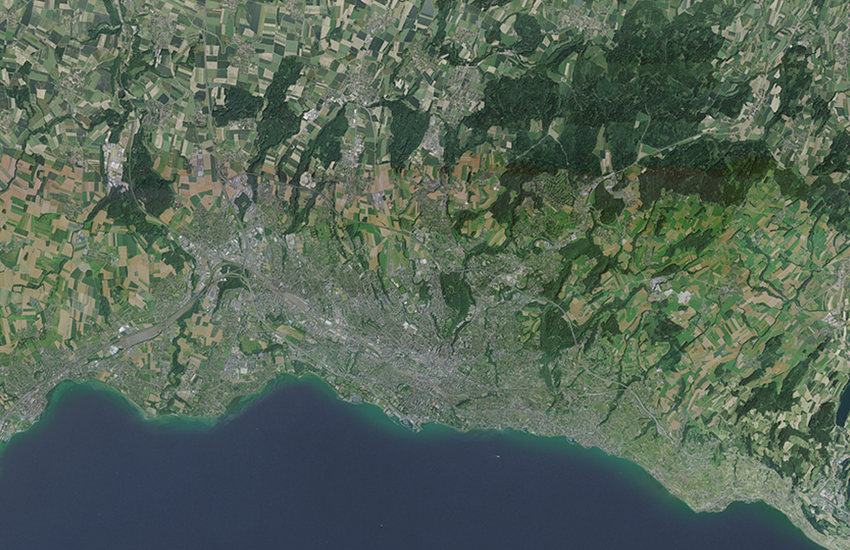
Das Mosaik der Landsat Satellitenbilder ist aus aus ca 20 einzelnen Aufnahmen des amerikanischen Satelliten Landsat 5, aus den Jahren 1990 bis 1994, zusammengesetzt. Es bildet einen flächendeckenden Bilddatensatz in natürlichen Farben und mit 25m Bodenauflösung.
La mosaïque Landsat est constituée d'environ 20 images individuelles, prises par le satellite américain Landsat 5, durant les années 1990 à 1994. Elle constitue un jeu de données image en couleurs naturelles, recouvrant l'ensemble de la Suisse, avec une résolution de 25m.
Il mosaico delle immagini satellitari Landsat è composto da circa 20 singole immagini riprese dal satellite americano Landsat 5 negli anni dal 1990 al 1994. Esso costituisce un set di dati immagine a colori naturali che copre tutto il territorio nazionale con una risoluzione al suolo di 25 metri.
The mosaic of Landsat satellite images is a composition of 20 individual images taken by the American satellite Landsat 5, in the years 1990 to 1994. It is a unique set of image data in natural colors, covering the whole territory of Switzerland in 25m resolution.
Il mosaic da las fotografias da satellit da Landsat sa cumpona da ca. 20 fotografias singulas dal satellit american Landsat 5 dals onns 1990 fin 1994. El furma ina unitad da datas fotografica en colurs natiralas e cun ina dissoluziun al fund da 25 m.
Simple
-
Autre titreAltri nomi o acronimiAlternate titleAlternate titleAlternativtitel
-
Landsat Mosaik 25
Landsat Mosaique 25
Mosaico Landsat 25
Landsat Mosaic 25
Mosaic Landsat 25
-
Date (Publication)Data (Pubblicazione)Date (Publication)Date (Publication)Datum (Publikation)
- 1999-01-01
-
Date (Création)Data (Creazione)Date (Creation)Date (Creation)Datum (Erstellung)
- 1990-01-01T00:00:00
-
Date (Dernière révision)Data (Ultima revisione)Date (Last Revision)Date (Last Revision)Datum (Letzte Überprüfung)
- 1994-12-31T00:00:00
-
IdentifiantIdentificatoreIdentifierIdentifierKennung
- ch.swisstopo.images-landsat25
-
ButScopoPurposePurposeZweck
-
Referenzdaten
-
ÉtatStatoStatusStatusBearbeitungsstatus
-
TerminéCompletatoCompletedCompletedAbgeschlossen
Fournisseur
Fornitore di risorse
Resource provider
Resource provider
Anbieter
-
Heures de serviceOrario di servizioHours of serviceHours of serviceBetriebszeiten
-
08h30 - 11h00 / 14h00 - 16h00 GMT+1
Propriétaire
Proprietario
Owner
Owner
Eigentümer
-
Type de représentation spatialeTipo di rappresentazione spazialeSpatial representation typeSpatial representation typeRäumliche Darstellungsart
-
grilleRasterGridGridRaster, Gitter
Résolution spatiale
Risoluzione spaziale
Spatial resolution
Spatial resolution
Räumliche Auflösung
-
Distance de résolutionDistanza di risoluzioneSpatial resolutionSpatial resolutionDistanz
- 25 m
-
Catégorie de thèmeCategoria ISOTopic categoryTopic categoryThematik
-
-
A Imagerie, cartes de base et occupation du solA Mappe di base con immagini della copertura terrestreA Imagery base maps earth coverA Imagery base maps earth coverA Oberflächenbeschreibung
-
Étendue
Estensione
Extent
Extent
Ausdehnung
Étendue
Estensione
Extent
Extent
Ausdehnung
-
DescriptionDescrizioneDescriptionDescriptionBeschreibung
-
Satellite images (swisstopo)
Satellitenbilder (swisstopo)
Images satellites (swisstopo)
Immagini satellite (swisstopo)
Satellitenbilder (swisstopo)
-
Identifiant géographiqueIdentificatore geograficoGeographic identifierGeographic identifierGeografische Kennung
- satsatsatsatsat
))

-
Fréquence de mise à jourFrequenza di aggiornamentoMaintenance and update frequencyMaintenance and update frequencyWartungsintervall
-
Non planifiéeNon pianificatoNot plannedNot plannedNicht geplant
-
Durée de conservationDurata di conservazioneDuration of ConservationDuration of ConservationAufbewahrungsdauer NV in Jahren
- 275
-
Évaluation de la valeur archivistiqueValutazione del valore archivisticoAppraisal of Archival ValueAppraisal of Archival ValueBewertung Archivwürdigkeit
-
AAAAA
-
Raison de la valeur d'archivageMotivo del valore archivisticoReason for Archiving ValueReason for Archiving ValueBegründung Archivwürdigkeit
-
Preuve de la pratique couranteProva della pratica commercialeEvidence of business practiceEvidence of business practiceNachweis der Geschäftspraxis
Format de la ressource
Formato della risorsa
Resource format
Resource format
Format der Ressource
-
TitreTitoloTitleTitleTitel
-
GeoTIFF (GEOTIFF)
-
DateDataDateDateDatum
- geocat.ch
-
-
géodonnées
geodati
geodata
-
opendata.swiss
opendata.swiss
opendata.swiss
opendata.swiss
-
Planification de la conservation et de l'archivage AAP - Conféderation
Pianificazione della conservazione e dell’archiviazione AAP - Confederazione
Conservation and archiving planning AAP - Confederation
-
géodonnées de base
geodati di base
official geodata
-
IFDG l’Infrastructure Fédérale de données géographiques
IFDG Infrastruttura federale dei dati geografici
FSDI Federal Spatial Data Infrastructure
-
- GEMET
-
-
image satellite
immagine da satellite
satellite image
-
- GEMET - INSPIRE themes, version 1.0
-
-
Ortho-imagerie
Orto immagini
Orthoimagery
-
Ressource associée
Risorsa associata
Associated resource
Associated resource
Verlinkte Ressource
-
TitreTitoloTitleTitleTitel
-
Orthophotos (Landesvermessung)
Orthophotos (mensuration nationale)
Ortofoto (misurazione nazionale)
-
Type d'associationTipo di associazioneAssociation TypeAssociation TypeAssoziationstyp
-
Citation de travail plus largeCitazione di un'opera più ampiaReference to a master resource of which this one is a partReference to a master resource of which this one is a partÜbergeordneter Datenbestand
-
LangueLinguaLanguageLanguageSprache
- Deutsch
-
Encodage de caractèresCodifica dei caratteriCharacter encodingCharacter encodingZeichenkodierung
-
Utf8UTF8UTF8UTF8Utf8
-
Catégorie de sous-thèmeCategoria di sottotemaSubtopic CategorySubtopic CategoryThematische Unterkategorien
-
A3 Images aériennes, satellitesA3 Immagini aeree e satellitariA3 Aerial and Satellite ImageryA3 Aerial and Satellite ImageryA3 Luft-, Satellitenbilder
-
Description de l'attributDescrizione dell'attributoAttribute descriptionAttribute descriptionBeschreibung des Attributs
- RGB-Farbwerte
-
Format de distributionFormato (codifica)Distribution formatDistribution formatAbgabeformat
-
-
nan
-
Options de transfert numérique
Opzioni di trasferimento digitale
Digital transfer options
Digital transfer options
Optionen für die digitale Übertragung
Options de transfert numérique
Opzioni di trasferimento digitale
Digital transfer options
Digital transfer options
Optionen für die digitale Übertragung
-
Ressource en ligneRisorsa onlineOnLine resourceOnLine resourceOnline
-
ch.swisstopo.images-landsat25
WMS-BGDI Dienst, Layer "Landsat Mosaik 25"Service WMS-IFDG, couche "Landsat Mosaique 25"Servizio WMS-IFDG, strato "Mosaico Landsat 25"WMS-FSDI service, layer "Landsat Mosaic 25"WMS-BGDI Dienst, Layer "Landsat Mosaik 25"
-
Généralités sur la provenanceInformazioni generali sulla provenienzaStatementStatementErklärung
-
Mosaik von Landsat Satellitenbilder
mosaique d?image satellite Landsat
mosaic of Landsat satellite images
-
NiveauLivelloHierarchy levelHierarchy levelBezugsebene
-
Jeu de donnéesSet di datiDatasetDatasetDatenbestand
-
Nombre de dimensionsNumero di dimensioniNumber of dimensionsNumber of dimensionsAnzahl der Dimensionen
- 2
-
Nom de dimensionNome della dimensioneDimension nameDimension nameDimensionsname
-
Axe - XColonnaColumnColumnX-Achse
-
Taille de dimensionDimensione della dimensioneDimension sizeDimension sizeDimensionsgröße
- 8750
-
RésolutionRisoluzioneResolutionResolutionAuflösung
- 5 m
-
Nom de dimensionNome della dimensioneDimension nameDimension nameDimensionsname
-
Axe - YRigaRowRowY-Achse
-
Taille de dimensionDimensione della dimensioneDimension sizeDimension sizeDimensionsgröße
- 6000
-
RésolutionRisoluzioneResolutionResolutionAuflösung
- 5 m
-
Géométrie de la celluleGeometria della cellaCell geometryCell geometryZellgeometrie
-
SurfaceAreaAreaAreaFläche
-
Disponibilité des paramètres de transformationDisponibilità dei parametri di trasformazioneTransformation parameter availabilityTransformation parameter availabilityVerfügbarkeit der Transformationsparameter
- 0
-
Nom du système de référenceNome del sistema di riferimentoReference system identifierReference system identifierName des Referenzsystems
- Referenzsystem entsprechend der zugrundeliegenden topographischen Karte (CH1903)
Metadata
-
Identifiant des métadonnéesIdentificativo della schedaMetadata identifierMetadata identifierIdentifikator des Metadatensatzes
- 2c8e0a96-67ea-4a6d-86eb-88f8272e0639
-
LangueLinguaLanguageLanguageSprache
- Deutsch
-
Encodage de caractèresCodifica dei caratteriCharacter encodingCharacter encodingZeichenkodierung
-
Utf8UTF8UTF8UTF8Utf8
-
LangueLinguaLanguageLanguageSprache
- Français
-
Encodage de caractèresCodifica dei caratteriCharacter encodingCharacter encodingZeichenkodierung
-
Utf8UTF8UTF8UTF8Utf8
-
LangueLinguaLanguageLanguageSprache
- Italiano
-
Encodage de caractèresCodifica dei caratteriCharacter encodingCharacter encodingZeichenkodierung
-
Utf8UTF8UTF8UTF8Utf8
-
LangueLinguaLanguageLanguageSprache
- English
-
Encodage de caractèresCodifica dei caratteriCharacter encodingCharacter encodingZeichenkodierung
-
Utf8UTF8UTF8UTF8Utf8
-
LangueLinguaLanguageLanguageSprache
- Rumantsch
-
Encodage de caractèresCodifica dei caratteriCharacter encodingCharacter encodingZeichenkodierung
-
Utf8UTF8UTF8UTF8Utf8
Dépositaire
Custode
Custodian
Custodian
Verwalter
-
Heures de serviceOrario di servizioHours of serviceHours of serviceBetriebszeiten
-
08h30 - 11h00 / 14h00 - 16h00 GMT+1
Type de ressource
Tipo di risorsa
Type of resource
Type of resource
Anwendungsbereich der Metadaten
-
Domaine d'application de la ressourceAmbito di applicazione della risorsaResource scopeResource scopeDomäne der Ressourcenanwendung
-
Jeu de donnéesSet di datiDatasetDatasetDatenbestand
-
Lien vers la métadonnéeCollegamento ai metadatiMetadata linkageMetadata linkageLink zu den Metadaten
-
Informations de date (Création)Informazioni sulla data (Creazione)Date info (Creation)Date info (Creation)Datumsangaben (Erstellung)
- 2008-05-08T12:00:00Z
-
Informations de date (Révision)Informazioni sulla data (Revisione)Date info (Revision)Date info (Revision)Datumsangaben (Aktualisierung)
- 2026-04-13T09:46:19.439807Z
Norme des métadonnées
Standard dei metadati
Metadata standard
Metadata standard
Metadatenstandard
-
TitreTitoloTitleTitleTitel
-
eCH-0271