geocat.ch
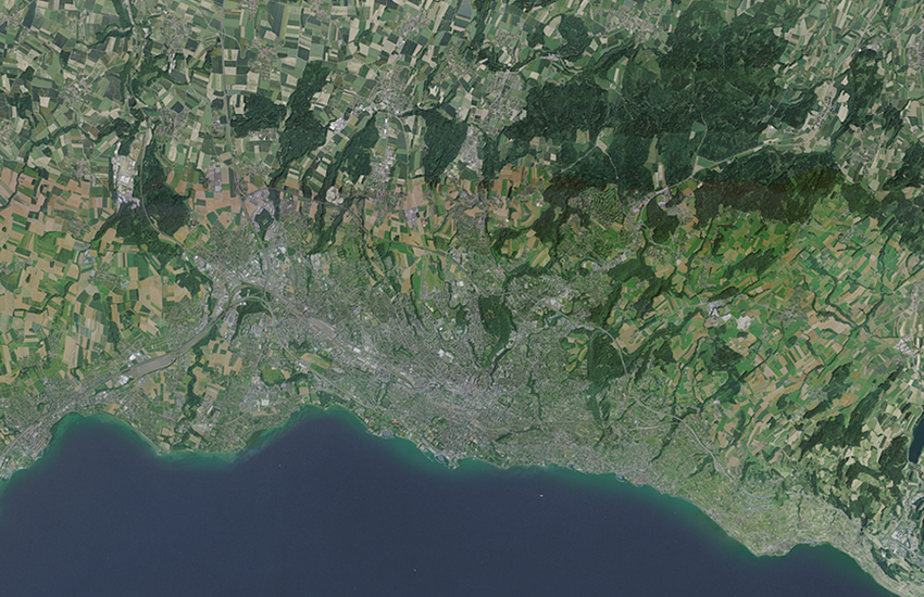
Landsat Mosaic of Switzerland
The mosaic of Landsat satellite images is a composition of 20 individual images taken by the American satellite Landsat 5, in the years 1990 to 1994. It is a unique set of image data in natural colors, covering the whole territory of Switzerland in 25m resolution.
Simple
- Alternate title
-
Landsat Mosaic 25
- Date (Publication)
- 1999-01-01
- Date (Creation)
- 1990-01-01T00:00:00
- Date (Last Revision)
- 1994-12-31T00:00:00
- Identifier
- ch.swisstopo.images-landsat25
- Purpose
-
Referenzdaten
- Status
- Completed
Resource provider
- Hours of service
-
08h30 - 11h00 / 14h00 - 16h00 GMT+1
Owner
- Spatial representation type
- Grid
Spatial resolution
- Spatial resolution
- 25 m
- Topic category
-
- A Imagery base maps earth cover
Extent
Extent
- Description
-
Satellite images (swisstopo)
- Geographic identifier
- sat
))

- Maintenance and update frequency
- Not planned
- Duration of Conservation
- 275
- Appraisal of Archival Value
- A
- Reason for Archiving Value
- Evidence of business practice
Resource format
- Title
-
GeoTIFF (GEOTIFF)
- Date
- geocat.ch
-
-
geodata
-
opendata.swiss
-
Conservation and archiving planning AAP - Confederation
-
official geodata
-
FSDI Federal Spatial Data Infrastructure
-
- GEMET
-
-
satellite image
-
- GEMET - INSPIRE themes, version 1.0
-
-
Orthoimagery
-
Associated resource
- Title
-
Orthophotos (Landesvermessung)
- Association Type
- Reference to a master resource of which this one is a part
- Language
- Deutsch
- Character encoding
- UTF8
- Subtopic Category
- A3 Aerial and Satellite Imagery
- Attribute description
- RGB-Farbwerte
- Distribution format
-
-
nan
-
Digital transfer options
Digital transfer options
- OnLine resource
-
ch.swisstopo.images-landsat25
WMS-FSDI service, layer "Landsat Mosaic 25"
- Statement
-
mosaic of Landsat satellite images
- Hierarchy level
- Dataset
- Number of dimensions
- 2
- Dimension name
- Column
- Dimension size
- 8750
- Resolution
- 5 m
- Dimension name
- Row
- Dimension size
- 6000
- Resolution
- 5 m
- Cell geometry
- Area
- Transformation parameter availability
- 0
- Reference system identifier
- Referenzsystem entsprechend der zugrundeliegenden topographischen Karte (CH1903)
Metadata
- Metadata identifier
- 2c8e0a96-67ea-4a6d-86eb-88f8272e0639
- Language
- Deutsch
- Character encoding
- UTF8
- Language
- Français
- Character encoding
- UTF8
- Language
- Italiano
- Character encoding
- UTF8
- Language
- English
- Character encoding
- UTF8
- Language
- Rumantsch
- Character encoding
- UTF8
Custodian
Type of resource
- Resource scope
- Dataset
- Metadata linkage
-
https://www.geocat.ch/geonetwork/srv/api/records/2c8e0a96-67ea-4a6d-86eb-88f8272e0639
- Date info (Creation)
- 2008-05-08T12:00:00Z
- Date info (Revision)
- 2026-04-13T09:46:19.439807Z
Metadata standard
- Title
-
eCH-0271