geocat.ch
swissTLMRegio
swissTLMRegio
swissTLMRegio
swissTLMRegio
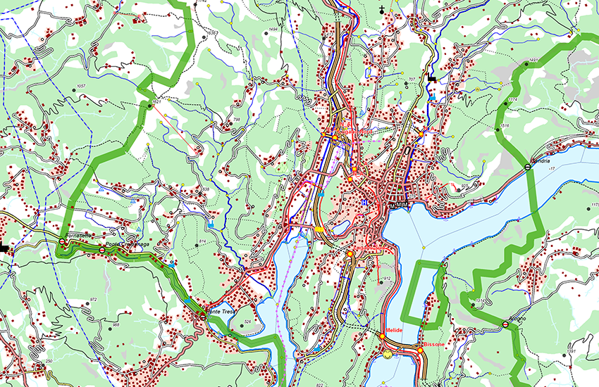
swissTLMRegio ist ein zweidimensionales Landschaftsmodell, welches die natürlichen und künstlichen Objekte der Landschaft im Vektorformat wiedergibt. Mit seinem hohen Generalisierungsgrad stellt es einen Referenzdatensatz für Übersichtsarbeiten auf regionaler und nationaler Ebene dar. swissTLMRegio beschreibt von über einer Million Objekten die Lage, die Form, die Nachbarschaftsbeziehungen (Topologie), die Objektart, welche sie repräsentieren, sowie andere Sachattribute. swissTLMRegio besteht aus 6 thematischen Gruppen (Topics), wovon jede verschiedene Objektklassen umfasst: Transportation (Verkehr), Hydrography (Gewässer), Landcover (Bodenbedeckung), Buildings (Gebäude), Miscellaneous (Verschiedenes), Names (Namen).
swissTLMRegio est un modèle bidimensionnel du territoire qui restitue les objets naturels et construits du paysage au format vectoriel. Grâce à son haut degré de généralisation, il constitue un produit de géodonnées de référence pour des travaux d'ensemble au niveau régional et national.
swissTLMRegio décrit plus d'un million d'objets par leur position, leur forme, leurs relations avec leur voisinage (topologie), le type d’objet qu'ils représentent ainsi que d'autres attributs descriptifs. swissTLMRegio est composé de six groupes thématiques (Topics) qui comprennent chacun différentes classes d'objets (Feature Classes): Transportation (transport), Hydrography (hydrographie), Landcover (couverture du sol), Buildings (bâtiments), Miscellaneous (divers), Names (noms).
swissTLMRegio is a 2D landscape model, which represents the natural and man-made features of the landscape in vector format. With its high generalisation grade it is a reference dataset for applications requiring a regional or national overview.
swissTLMRegio describes more than one million objects with their location, shape and neighbourhood connections (topology) as well as the object type and further attributes. swissTLMRegiois composed of 6 thematic topics. Each topic contains one or more feature classes: Transportation, Hydrography, Landcover, Buildings, Miscellaneous, Names.
Simple
-
Date (Publication)Data (Pubblicazione)Date (Publication)Datum (Publikation)
- 2012-02-24
-
Date (Révision)Data (Revisione)Date (Revision)Datum (Aktualisierung)
- 2025-12-02
-
IdentifiantIdentificatoreIdentifierKennung
- ch.swisstopo.swisstlmregio
-
ÉtatStatoStatusBearbeitungsstatus
-
TerminéCompletatoCompletedAbgeschlossen
Point de contact
Punto di contatto
Point of contact
Ansprechpartner
Propriétaire
Proprietario
Owner
Eigentümer
-
Type de représentation spatialeTipo di rappresentazione spazialeSpatial representation typeRäumliche Darstellungsart
-
vecteurVettorialeVectorVektor
Résolution spatiale
Risoluzione spaziale
Spatial resolution
Räumliche Auflösung
Fraction représentative
Frazione rappresentativa
Equivalent scale
Vergleichsmassstab
-
DénominateurDenominatoreDenominatorMassstabszahl
- 200000
-
Catégorie de thèmeCategoria ISOTopic categoryThematik
-
-
A Imagerie, cartes de base et occupation du solA Mappe di base con immagini della copertura terrestreA Imagery base maps earth coverA Oberflächenbeschreibung
-
G BioteG BiotaG BiotaG Biologie
-
O StructureO StrutturaO StructureO Bauwerke
-
D LimitesD ConfiniD BoundariesD Grenzen
-
I Eaux intérieuresI Acque interneI Inland watersI Binnengewässer
-
P TransportP TrasportiP TransportationP Verkehrswesen
-
C ÉlévationC AltitudineC ElevationC Höhenangaben
-
Étendue
Estensione
Extent
Ausdehnung
Étendue
Estensione
Extent
Ausdehnung
-
DescriptionDescrizioneDescriptionBeschreibung
-
swissTLMRegio
swissTLMRegio
swissTLMRegio
swissTLMRegio
Identifiant
Identificativo
Identifier
Identifikator
-
CodeCodiceCodeCode
))

-
Fréquence de mise à jourFrequenza di aggiornamentoMaintenance and update frequencyWartungsintervall
-
AnnuelleAnnualmenteAnnuallyJährlich
-
Durée de conservationDurata di conservazioneDuration of ConservationAufbewahrungsdauer NV in Jahren
- 275
-
Évaluation de la valeur archivistiqueValutazione del valore archivisticoAppraisal of Archival ValueBewertung Archivwürdigkeit
-
AAAA
-
Raison de la valeur d'archivageMotivo del valore archivisticoReason for Archiving ValueBegründung Archivwürdigkeit
-
Preuve de la pratique couranteProva della pratica commercialeEvidence of business practiceNachweis der Geschäftspraxis
- geocat.ch
-
-
SIG (Système d'Information Géographique)
SIG (Sistema Informativo Geografico)
GIS (Geographic Information System)
-
opendata.swiss
opendata.swiss
opendata.swiss
-
IFDG l’Infrastructure Fédérale de données géographiques
IFDG Infrastruttura federale dei dati geografici
FSDI Federal Spatial Data Infrastructure
-
- geocat.ch
-
-
symbole individuel
simbolo individuale
individual Symbol
-
- geocat.ch
-
-
géodonnées de base
geodati di base
official geodata
-
- geocat.ch
-
-
Planification de la conservation et de l'archivage AAP - Conféderation
Pianificazione della conservazione e dell’archiviazione AAP - Confederazione
Conservation and archiving planning AAP - Confederation
-
- geocat.ch
-
-
réseau de transport
rete di trasporto
traffic network
-
- GEMET - INSPIRE themes, version 1.0
-
-
Occupation des terres
Copertura del suolo
Land cover
-
- geocat.ch
-
-
couverture du sol
copertura del suolo
land cover
-
- GEMET - INSPIRE themes, version 1.0
-
-
Bâtiments
Edifici
Buildings
-
- GEMET - INSPIRE themes, version 1.0
-
-
Hydrographie
Idrografia
Hydrography
-
- GEMET
-
-
bordure
frontiera
border
-
- GEMET
-
-
système d'information géographique
sistema informativo geografico
geographic information system
-
Contraintes sur la ressource
Vincoli sulle risorse
Resource constraints
Ressourcenbeschränkungen
-
Autres contraintesAltri vincoliOther constraintsAndere Einschränkungen
- Opendata BY: Freie Nutzung. Quellenangabe ist Pflicht.Opendata BY: Utilisation libre. Obligation d’indiquer la source.Opendata BY: Libero utilizzo. Indicazione della fonte obbligatoria.Opendata BY: Open use. Must provide the source.
Ressource associée
Risorsa associata
Associated resource
Verlinkte Ressource
-
TitreTitoloTitleTitel
-
Topografisches Landschaftsmodell (Landesvermessung)
Modèle topographique du paysage (mensuration nationale)
Modello topografico del paesaggio (misurazione nazionale)
-
Type d'associationTipo di associazioneAssociation TypeAssoziationstyp
-
Citation de travail plus largeCitazione di un'opera più ampiaReference to a master resource of which this one is a partÜbergeordneter Datenbestand
-
LangueLinguaLanguageSprache
- English
-
Encodage de caractèresCodifica dei caratteriCharacter encodingZeichenkodierung
-
Utf8UTF8UTF8Utf8
-
LangueLinguaLanguageSprache
- Deutsch
-
Encodage de caractèresCodifica dei caratteriCharacter encodingZeichenkodierung
-
Utf8UTF8UTF8Utf8
-
Catégorie de sous-thèmeCategoria di sottotemaSubtopic CategoryThematische Unterkategorien
-
A1 Cartes de base, modèles de paysageA1 Mappe di base, modelli paesaggisticiA1 Base Maps, Landscape ModelsA1 Basiskarten, Landschaftsmodelle
-
Géodonnées de baseGeodati di baseBasic GeodataGeobasisdaten
- true
-
Identifiant Géodonnées de baseIdentificativo dei geodati di baseBasic Geodata IDIdentifikator des Geobasisdatensatzes
-
38.11
-
Niveau des géodonnées de baseLivello legale dei geodati di baseBasic Geodata Legal LevelGeobasisdatenebene
-
FédéralFederaleFederalNational
-
Type de géodonnées de baseTipo di geodati di baseBasic Geodata TypeGeobasisdatentyp
-
Géodonnées de référenceGeodati di riferimentoReference GeodataGeoreferenzdaten
-
Format de distributionFormato (codifica)Distribution formatAbgabeformat
-
-
ESRI Shapefile (SHP)
-
INTERLIS 2 (XTF)
-
ESRI File Geodatabase FileGDB (GDB)
-
AutoCAD DXF (DXF)
-
OGC Geopackage (GPKG)
-
Options de transfert numérique
Opzioni di trasferimento digitale
Digital transfer options
Optionen für die digitale Übertragung
Options de transfert numérique
Opzioni di trasferimento digitale
Digital transfer options
Optionen für die digitale Übertragung
Options de transfert numérique
Opzioni di trasferimento digitale
Digital transfer options
Optionen für die digitale Übertragung
-
Généralités sur la provenanceInformazioni generali sulla provenienzaStatementErklärung
-
Auf einem 1:200'000 Massstab basierend. Lagegenauigkeit: 20-60 m.
Se base sur une échelle au 1:200'000. Précision de position: 20-60 m.
precisione della posizione: 20-60 m (corrispondente alla scala 1:200 000)
Based on a 1:200'000 scale. Geometric precision: 20-60 m.
-
NiveauLivelloHierarchy levelBezugsebene
-
Jeu de donnéesSet di datiDatasetDatenbestand
-
Niveau de topologieLivello di topologiaTopology levelTopologieebene
-
Topologie de réseauTopologia 1DTopology 1DNetzwerktopologie
-
Type d’objet géométriqueTipo di oggetto geometricoGeometric object typeTyp des geometrischen Objekts
-
PolygoneSuperficieSurfacesurface
-
Nombre d’objets géométriquesNumero di oggetti geometriciGeometric object countAnzahl geometrischer Objekte
- 391807
-
Type d’objet géométriqueTipo di oggetto geometricoGeometric object typeTyp des geometrischen Objekts
-
LigneCurvaCurvecurve
-
Nombre d’objets géométriquesNumero di oggetti geometriciGeometric object countAnzahl geometrischer Objekte
- 155326
-
Type d’objet géométriqueTipo di oggetto geometricoGeometric object typeTyp des geometrischen Objekts
-
PointPuntoPointpoint
-
Nombre d’objets géométriquesNumero di oggetti geometriciGeometric object countAnzahl geometrischer Objekte
- 148215
-
Nom du système de référenceNome del sistema di riferimentoReference system identifierName des Referenzsystems
- EPSG:21781
-
Nom du système de référenceNome del sistema di riferimentoReference system identifierName des Referenzsystems
- EPSG:2056
Metadata
-
Identifiant des métadonnéesIdentificativo della schedaMetadata identifierIdentifikator des Metadatensatzes
- 2a190233-498a-46c4-91ca-509a97d797a2
-
LangueLinguaLanguageSprache
- Deutsch
-
Encodage de caractèresCodifica dei caratteriCharacter encodingZeichenkodierung
-
Utf8UTF8UTF8Utf8
-
LangueLinguaLanguageSprache
- Français
-
Encodage de caractèresCodifica dei caratteriCharacter encodingZeichenkodierung
-
Utf8UTF8UTF8Utf8
-
LangueLinguaLanguageSprache
- Italiano
-
Encodage de caractèresCodifica dei caratteriCharacter encodingZeichenkodierung
-
Utf8UTF8UTF8Utf8
-
LangueLinguaLanguageSprache
- English
-
Encodage de caractèresCodifica dei caratteriCharacter encodingZeichenkodierung
-
Utf8UTF8UTF8Utf8
Point de contact
Punto di contatto
Point of contact
Ansprechpartner
-
Heures de serviceOrario di servizioHours of serviceBetriebszeiten
-
08h30 - 11h00 / 14h00 - 16h00 GMT+1
Type de ressource
Tipo di risorsa
Type of resource
Anwendungsbereich der Metadaten
-
Domaine d'application de la ressourceAmbito di applicazione della risorsaResource scopeDomäne der Ressourcenanwendung
-
Jeu de donnéesSet di datiDatasetDatenbestand
-
Informations de date (Création)Informazioni sulla data (Creazione)Date info (Creation)Datumsangaben (Erstellung)
- 2020-10-28T07:23:03Z
-
Informations de date (Révision)Informazioni sulla data (Revisione)Date info (Revision)Datumsangaben (Aktualisierung)
- 2026-04-13T09:38:41.378677Z
Norme des métadonnées
Standard dei metadati
Metadata standard
Metadatenstandard
-
TitreTitoloTitleTitel
-
eCH-0271