geocat.ch
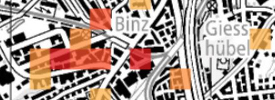
Thermal networks: demand from industry
In strategic planning, heat demand is used to identify large connected areas that may be appropriate for a thermal network. Areas with a heat density of at least 700 MWh/a per hectare are considered suitable. As well as heat density, heat must be supplied at a specific temperature. Some industries require process heat at a very high temperature (sometimes 1,000°C or more), and this cannot be generated by a thermal network. Heat demand from industry has therefore been recorded in a separate data set. The data are based on the Federal Statistical Office's 2013 Statistics on Company Structures (not available in English) and the Federal Office of Energy's figures in the annual report ‘Energy consumption in the industry and services sector'. On the hectare grid, heat demand is represented as heat density shown on a colour scale. The information is provided for the general public and is not official or legally binding.
Simple
- Alternate title
-
Heat/cooling demand: industry
- Date (Creation)
- 2013-12-31
- Identifier
- ch.bfe.fernwaerme-nachfrage_industrie
Owner
- Topic category
-
- Q Utilities communication
Extent
Extent
- Description
-
Switzerland
))

- Maintenance and update frequency
- Annually
- Duration of Conservation
- 25
- Appraisal of Archival Value
- A
- Reason for Archiving Value
- Evidence of business practice
- geocat.ch
-
-
Conservation and archiving planning AAP - Confederation
-
opendata.swiss
-
- geocat.ch
-
-
FSDI Federal Spatial Data Infrastructure
-
Resource constraints
- Use constraints
- Other restrictions
- Other constraints
- Opendata BY: Open use. Must provide the source.
- Language
- Deutsch
- Character encoding
- UTF8
- Language
- Français
- Character encoding
- UTF8
- Language
- Italiano
- Character encoding
- UTF8
- Subtopic Category
- Q1 Energy
- Basic Geodata
- false
- Basic Geodata Legal Level
- Federal
- Distribution format
-
-
INTERLIS 2 (XTF)
-
OGC Geopackage (GPKG)
-
GeoTIFF (GEOTIFF)
-
Digital transfer options
Digital transfer options
- OnLine resource
-
Geopackage
Geopackage
Digital transfer options
- OnLine resource
-
GeoTIFF
GeoTIFF
Digital transfer options
- OnLine resource
-
ch.bfe.fernwaerme-nachfrage_industrie
WMS-FSDI service, layer "Heat/cooling demand: industry"
Digital transfer options
- OnLine resource
-
ch.bfe.fernwaerme-nachfrage_industrie
WMTS-FSDI service, layer "Heat/cooling demand: industry"
Digital transfer options
- OnLine resource
-
Interlis
Interlis
Digital transfer options
- OnLine resource
-
Fachportal - map.energie.admin.ch
Thematic geoportal - map.energie.admin.ch
Digital transfer options
- OnLine resource
-
swisstopo REST API
swisstopo REST API
- Geometric object type
- Surface
- Reference system identifier
- EPSG:2056
Metadata
- Metadata identifier
- 25de2a79-1714-4db8-a7ad-48efc8a4f5c7
- Language
- Deutsch
- Character encoding
- UTF8
- Language
- Français
- Character encoding
- UTF8
- Language
- Italiano
- Character encoding
- UTF8
- Language
- English
- Character encoding
- UTF8
- Language
- Rumantsch
- Character encoding
- UTF8
Point of contact
Type of resource
- Resource scope
- Dataset
- Metadata linkage
-
https://www.geocat.ch/geonetwork/srv/api/records/25de2a79-1714-4db8-a7ad-48efc8a4f5c7
- Date info (Creation)
- 2018-10-03T05:45:55Z
- Date info (Revision)
- 2026-04-13T09:45:56.500631Z
Metadata standard
- Title
-
eCH-0271