geocat.ch
Potenzielle Korridore zwischen Schutzobjekten für Offenland-Feuchtgebietsarten (OFG-Arten)
Corridors potentiels entre objets protégés pour les espèces des zones humides ouvertes (OFG-Arten)
Potential corridors between protected sites for open-land wetland species (OFG-Arten)
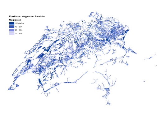
Der Datensatz zeigt potenzielle Ausbreitungskorridore für Arten offener Feuchtgebiete (OFG-Arten) zwischen Feuchtgebieten in nationalen und regionalen Inventaren. Die Korridorraster ergänzt die idealisierten Least-Costs-Pfade aus dem verwandtem Layer, "Korridore Qualität" mit Fehlerbalken und liefert so eine zweidimensionale Darstellung potenzieller Korridore um die optimalen Ausbreitungsrouten herum. Zusammen heben die beiden Karten potenzielle Routen zwischen geschützten Feuchtgebieten hervor und ordnen sie nach ihrer Durchlässigkeit ein, was eine räumlich explizite Priorisierung von Wiedervernässungsinitiativen ermöglicht.
Die Bewegungskorridore wurden durch Pufferung der kostengünstigsten Pfade zwischen Feuchtgebieten in Schritten von 10 % Erhöhung der Kosten-Entfernung erstellt. Die dunkelsten blauen Korridore enthalten die 10 % der Zellen mit der geringsten Abweichung der Kostenentfernung vom Pfad der geringsten Kosten. Neben der Hervorhebung möglicher sekundärer und tertiärer Routen zwischen Standorten kann die Interpretation dieser Karten nützliche Einblicke in die lokale Landschaft und die Konnektivität innerhalb der Region bieten. In Gebieten, in denen der Weg der geringsten Kosten durch einen breiten Streifen feuchter Lebensräume führt, wird der Korridor breiter, was darauf hindeutet, dass der Weg der geringsten Kosten hier nur eine von vielen möglichen Routen durch den Standort ist. Wenn sich der Korridor hingegen verengt, ist die Ausbreitung auf einen schmalen Streifen eines geeigneten Lebensraums beschränkt.
Weitere Einzelheiten über die Erstellung und Anwendung der Korridorkarten finden Sie unter:
Churko, G., Walter, T., Szerencsits, E., & Gramlich, A. (2020). Improving wetland connectivity through the promotion of wet arable land. Wetlands Ecology and Management, 28(4), 667–680.
Churko, Greg, Szerencsits, Erich, Gramlich, Anja, Prasuhn, Volker, & Walter, Thomas. (2018). Arten der Feucht-(Acker-) Flächen in der Schweiz und Korridore zwischen Schutzobjekten. Agroscope Science, 76, 1–39.
Roberti G., Gramlich A., Benz R., Szerencsits E., Churko G., Prasuhn V., Leifeld J., Zorn A., Jacot-Ammann K., Herzog F., Fabian Y. Entscheidungshilfe für feuchte und nasse Ackerflächen : Unterstützung bei der Identifikation von Flächen, auf denen Alternativen zur Entwässerung in Betracht zu ziehen sind. Agroscope Transfer, 449, 2022, 1-68.
Couloirs de déplacement potentiels entre les sites de zones humides inventoriés au niveau national et régional pour les espèces de zones humides ouvertes (OFG-Arten). Ce raster de corridors complète les chemins idéaux à moindre coût de la couche associée « Qualité des corridors » avec des barres d'erreur, fournissant ainsi une représentation bidimensionnelle des corridors potentiels autour des itinéraires de dispersion optimaux.Ensemble, les deux cartes mettent en évidence et classent les routes potentielles entre les sites de zones humides protégées en fonction de leur perméabilité, ce qui permet d'établir des priorités spatiales explicites pour les initiatives de ré-humidification.
Les couloirs de migration ont été générés en tamponnant les chemins les moins coûteux entre les sites de zones humides par paliers de 10 % d'augmentation du coût de la distance. Les corridors bleu foncé contiennent les 10 % de cellules présentant l'écart le plus faible en termes de coût-distance par rapport au chemin le moins coûteux. Outre la mise en évidence d'éventuels chemins secondaires et tertiaires entre les sites, l'interprétation de ces cartes peut fournir des informations utiles sur le paysage local et la connectivité au sein de la région. Dans les zones où un chemin de moindre coût traverse une large bande d'habitats humides, le corridor s'élargit, ce qui suggère que le chemin de moindre coût n'est qu'un des nombreux itinéraires possibles dans la région. À l'inverse, lorsque le corridor se rétrécit, la dispersion est limitée à une mince bande d'habitat approprié.
Pour plus de détails sur la construction et l'application des cartes de corridors, voir :
Churko, G., Walter, T., Szerencsits, E., & Gramlich, A. (2020). Improving wetland connectivity through the promotion of wet arable land. Wetlands Ecology and Management, 28(4), 667–680.
Churko, Greg, Szerencsits, Erich, Gramlich, Anja, Prasuhn, Volker, & Walter, Thomas. (2018). Arten der Feucht-(Acker-) Flächen in der Schweiz und Korridore zwischen Schutzobjekten. Agroscope Science, 76, 1–39.
Roberti G., Gramlich A., Benz R., Szerencsits E., Churko G., Prasuhn V., Leifeld J., Zorn A., Jacot-Ammann K., Herzog F., Fabian Y.
Entscheidungshilfe für feuchte und nasse Ackerflächen : Unterstützung bei der Identifikation von Flächen, auf denen Alternativen zur Entwässerung in Betracht zu ziehen sind. Agroscope Transfer, 449, 2022, 1-68.
This dataset depicts potential movement corridors between nationally and regionally inventoried wetland sites for open wetland species (OFG-Arten). This corridor raster supplements the idealized least-cost paths from the related layer, “Corridor Quality” with error bars, providing a two-dimensional representation of potential corridors around the optimal dispersal routes. Together, the two maps highlight and rank potential routes between protected wetland sites according to their permeability, allowing spatially-explicit prioritization of re-wetting initiatives.
The movement corridors were generated by buffering the least-cost paths between wetland sites in steps of 10% increases in Cost-Distance. The darkest blue corridors contain the 10% of cells with the lowest deviation in cost-distance from the least-cost path. Besides highlighting possible secondary and tertiary routes between sites, interpretation of these maps can offer useful insights regarding the local landscape and connectivity within the region. In areas where a least-cost path travels through a wide swath of wet habitat, the corridor broadens, suggesting that the least-cost path here is but one of many likely routes through the location. Alternatively, when the corridor narrows,dispersal is restricted through a thin strip of suitable habitat.
For more details about the construction and application of the corridor maps, see:
Churko, G., Walter, T., Szerencsits, E., & Gramlich, A. (2020). Improving wetland connectivity through the promotion of wet arable land. Wetlands Ecology and Management, 28(4), 667–680.
Churko, Greg, Szerencsits, Erich, Gramlich, Anja, Prasuhn, Volker, & Walter, Thomas. (2018). Arten der Feucht-(Acker-) Flächen in der Schweiz und Korridore zwischen Schutzobjekten. Agroscope Science, 76, 1–39.
Roberti G., Gramlich A., Benz R., Szerencsits E., Churko G., Prasuhn V., Leifeld J., Zorn A., Jacot-Ammann K., Herzog F., Fabian Y.
Entscheidungshilfe für feuchte und nasse Ackerflächen : Unterstützung bei der Identifikation von Flächen, auf denen Alternativen zur Entwässerung in Betracht zu ziehen sind. Agroscope Transfer, 449, 2022, 1-68.
Simple
-
Autre titreAltri nomi o acronimiAlternate titleAlternate titleAlternativtitel
-
Feuchtgebietskorridore - Bereiche
Corridors zones humides – Zones
Wetland Corridors – Zones
-
Date (Publication)Data (Pubblicazione)Date (Publication)Date (Publication)Datum (Publikation)
- 2024-02-23
-
IdentifiantIdentificatoreIdentifierIdentifierKennung
- ch.agroscope.Korridore_Bereiche
Auteur principal de la recherche
Ricercatore principale
Principal investigator
Principal investigator
Projektleiter
-
ÉtatStatoStatusStatusBearbeitungsstatus
-
TerminéCompletatoCompletedCompletedAbgeschlossen
Point de contact
Punto di contatto
Point of contact
Point of contact
Ansprechpartner
-
Type de représentation spatialeTipo di rappresentazione spazialeSpatial representation typeSpatial representation typeRäumliche Darstellungsart
-
grilleRasterGridGridRaster, Gitter
Résolution spatiale
Risoluzione spaziale
Spatial resolution
Spatial resolution
Räumliche Auflösung
-
Distance de résolutionDistanza di risoluzioneSpatial resolutionSpatial resolutionDistanz
- 50 m
Étendue
Estensione
Extent
Extent
Ausdehnung
Étendue
Estensione
Extent
Extent
Ausdehnung
-
DescriptionDescrizioneDescriptionDescriptionBeschreibung
-
Switzerland
Schweiz
Suisse
Svizzera
Svizra
))

-
Fréquence de mise à jourFrequenza di aggiornamentoMaintenance and update frequencyMaintenance and update frequencyWartungsintervall
-
Non planifiéeNon pianificatoNot plannedNot plannedNicht geplant
Format de la ressource
Formato della risorsa
Resource format
Resource format
Format der Ressource
-
TitreTitoloTitleTitleTitel
-
Tagged Image File Format (TIFF)
-
DateDataDateDateDatum
Format de la ressource
Formato della risorsa
Resource format
Resource format
Format der Ressource
-
TitreTitoloTitleTitleTitel
-
Cloud Optimized GeoTIFF (TIFF / TIF)
-
DateDataDateDateDatum
-
ÉditionEdizioneEditionEditionAusgabe
-
-
- geocat.ch
-
-
confédération
confederazione
confederation
-
biodiversité
biodiversità
biodiversity
-
opendata.swiss
opendata.swiss
opendata.swiss
opendata.swiss
-
- GEMET themes
-
-
agriculture
agricoltura
agriculture
-
zones naturelles, paysages, écosystèmes
aree naturali, paesaggio, ecosistemi
natural areas, landscape, ecosystems
-
- GEMET
-
-
agriculture
agricoltura
agriculture
-
préservation de la nature
conservazione della natura
nature conservation
-
Contraintes sur la ressource
Vincoli sulle risorse
Resource constraints
Resource constraints
Ressourcenbeschränkungen
-
Contraintes d'accèsVincoli di accessoAccess constraintsAccess constraintsZugriffsbeschränkungen
-
Droit d’auteurCopyrightCopyrightCopyrightUrheberrecht
-
Contraintes d'utilisationVincoli d'usoUse constraintsUse constraintsNutzungseinschränkungen
-
Droit d’auteurCopyrightCopyrightCopyrightUrheberrecht
-
Autres contraintesAltri vincoliOther constraintsOther constraintsAndere Einschränkungen
- Opendata OPEN: Freie Nutzung.Opendata OPEN: Utilisation libre.Opendata OPEN: Libero utilizzo.Opendata OPEN: Open use.
-
LangueLinguaLanguageLanguageSprache
- Deutsch
-
Encodage de caractèresCodifica dei caratteriCharacter encodingCharacter encodingZeichenkodierung
-
Utf8UTF8UTF8UTF8Utf8
-
Géodonnées de baseGeodati di baseBasic GeodataBasic GeodataGeobasisdaten
- false
-
Niveau des géodonnées de baseLivello legale dei geodati di baseBasic Geodata Legal LevelBasic Geodata Legal LevelGeobasisdatenebene
-
FédéralFederaleFederalFederalNational
-
Type de géodonnées de baseTipo di geodati di baseBasic Geodata TypeBasic Geodata TypeGeobasisdatentyp
-
openDataopenDataopenDataopenDataopenData
-
Format de distributionFormato (codifica)Distribution formatDistribution formatAbgabeformat
-
-
Cloud Optimized GeoTIFF (TIFF / TIF)
-
Propriétaire
Proprietario
Owner
Owner
Eigentümer
-
Ressource en ligneRisorsa onlineOnLine resourceOnLine resourceOnline
-
STAC Broser
Link zum DatenbezugLien pour obtention des donnéesLink to data access
-
Ressource en ligneRisorsa onlineOnLine resourceOnLine resourceOnline
-
Vorschau map.geo.admin.ch
-
Ressource en ligneRisorsa onlineOnLine resourceOnLine resourceOnline
-
ch.agroscope.Korridore_Bereiche
WMS-BGDI Dienst, Layer "Korridore Bereiche"Service WMS-IFDG, couche "Zones de corridor"WMS-FSDI service, layer "Corridor zones"
-
Ressource en ligneRisorsa onlineOnLine resourceOnLine resourceOnline
-
ch.agroscope.Korridore_Bereiche
WMTS-BGDI Dienst, Layer "Korridore Bereiche"Service WMTS-IFDG, couche"Zones de corridor"WMTS-FSDI service, layer "Corridor zones"
-
Ressource en ligneRisorsa onlineOnLine resourceOnLine resourceOnline
-
Link zum Projekt
Options de transfert numérique
Opzioni di trasferimento digitale
Digital transfer options
Digital transfer options
Optionen für die digitale Übertragung
-
Ressource en ligneRisorsa onlineOnLine resourceOnLine resourceOnline
-
Churko_2020_WEM_WetlandCorridors.pdf
Zusätzliche LiteraturLiterature additonelleadditional literature
Options de transfert numérique
Opzioni di trasferimento digitale
Digital transfer options
Digital transfer options
Optionen für die digitale Übertragung
-
Ressource en ligneRisorsa onlineOnLine resourceOnLine resourceOnline
-
Churko_2020_Supplement_Geodata.pdf
Liste der Geodaten für ModellierungListe des géo-données pour le modèleList of geo-data for modelling
Options de transfert numérique
Opzioni di trasferimento digitale
Digital transfer options
Digital transfer options
Optionen für die digitale Übertragung
-
Ressource en ligneRisorsa onlineOnLine resourceOnLine resourceOnline
-
WetlandCorridors_data_description.pdf
Zusätzliche DatenbeschreibungDescription des données additionelleAdditional data description
Options de transfert numérique
Opzioni di trasferimento digitale
Digital transfer options
Digital transfer options
Optionen für die digitale Übertragung
-
Ressource en ligneRisorsa onlineOnLine resourceOnLine resourceOnline
-
Bereiche_Wegkosten_de.png
Legende DeutschLégende en allemandLegend in German
Options de transfert numérique
Opzioni di trasferimento digitale
Digital transfer options
Digital transfer options
Optionen für die digitale Übertragung
-
Ressource en ligneRisorsa onlineOnLine resourceOnLine resourceOnline
-
Legende_Zones_cout_fr.png
Legende FranzösichLégene françaisFrench legend
Options de transfert numérique
Opzioni di trasferimento digitale
Digital transfer options
Digital transfer options
Optionen für die digitale Übertragung
-
Ressource en ligneRisorsa onlineOnLine resourceOnLine resourceOnline
-
Churko_2021_speciesDiversity
Zusätzliche LiteraturLitérature supplémentaireAddtional literature
-
Type d’objet géométriqueTipo di oggetto geometricoGeometric object typeGeometric object typeTyp des geometrischen Objekts
-
PolygoneSuperficieSurfaceSurfacesurface
-
Nom du système de référenceNome del sistema di riferimentoReference system identifierReference system identifierName des Referenzsystems
- LV95 EPSG:2056
-
Fréquence de mise à jourFrequenza di aggiornamentoMaintenance and update frequencyMaintenance and update frequencyWartungsintervall
-
Comme nécessaireSecondo necessitàAs neededAs neededBei Bedarf
Metadata
-
Identifiant des métadonnéesIdentificativo della schedaMetadata identifierMetadata identifierIdentifikator des Metadatensatzes
- 1f1c2f2c-2c96-4f01-b404-63e6cd1d3e32
-
LangueLinguaLanguageLanguageSprache
- Deutsch
-
Encodage de caractèresCodifica dei caratteriCharacter encodingCharacter encodingZeichenkodierung
-
Utf8UTF8UTF8UTF8Utf8
-
LangueLinguaLanguageLanguageSprache
- Français
-
Encodage de caractèresCodifica dei caratteriCharacter encodingCharacter encodingZeichenkodierung
-
Utf8UTF8UTF8UTF8Utf8
-
LangueLinguaLanguageLanguageSprache
- Italiano
-
Encodage de caractèresCodifica dei caratteriCharacter encodingCharacter encodingZeichenkodierung
-
Utf8UTF8UTF8UTF8Utf8
-
LangueLinguaLanguageLanguageSprache
- English
-
Encodage de caractèresCodifica dei caratteriCharacter encodingCharacter encodingZeichenkodierung
-
Utf8UTF8UTF8UTF8Utf8
-
LangueLinguaLanguageLanguageSprache
- Rumantsch
-
Encodage de caractèresCodifica dei caratteriCharacter encodingCharacter encodingZeichenkodierung
-
Utf8UTF8UTF8UTF8Utf8
Propriétaire
Proprietario
Owner
Owner
Eigentümer
Type de ressource
Tipo di risorsa
Type of resource
Type of resource
Anwendungsbereich der Metadaten
-
Domaine d'application de la ressourceAmbito di applicazione della risorsaResource scopeResource scopeDomäne der Ressourcenanwendung
-
Jeu de donnéesSet di datiDatasetDatasetDatenbestand
-
Lien vers la métadonnéeCollegamento ai metadatiMetadata linkageMetadata linkageLink zu den Metadaten
-
Informations de date (Création)Informazioni sulla data (Creazione)Date info (Creation)Date info (Creation)Datumsangaben (Erstellung)
- 2024-03-21T09:23:43.478Z
-
Informations de date (Révision)Informazioni sulla data (Revisione)Date info (Revision)Date info (Revision)Datumsangaben (Aktualisierung)
- 2026-06-10T11:50:52.11082Z
Norme des métadonnées
Standard dei metadati
Metadata standard
Metadata standard
Metadatenstandard
-
TitreTitoloTitleTitleTitel
-
eCH-0271