geocat.ch
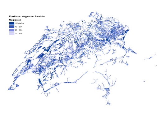
Potential corridors between protected sites for open-land wetland species (OFG-Arten)
This dataset depicts potential movement corridors between nationally and regionally inventoried wetland sites for open wetland species (OFG-Arten). This corridor raster supplements the idealized least-cost paths from the related layer, “Corridor Quality” with error bars, providing a two-dimensional representation of potential corridors around the optimal dispersal routes. Together, the two maps highlight and rank potential routes between protected wetland sites according to their permeability, allowing spatially-explicit prioritization of re-wetting initiatives.
The movement corridors were generated by buffering the least-cost paths between wetland sites in steps of 10% increases in Cost-Distance. The darkest blue corridors contain the 10% of cells with the lowest deviation in cost-distance from the least-cost path. Besides highlighting possible secondary and tertiary routes between sites, interpretation of these maps can offer useful insights regarding the local landscape and connectivity within the region. In areas where a least-cost path travels through a wide swath of wet habitat, the corridor broadens, suggesting that the least-cost path here is but one of many likely routes through the location. Alternatively, when the corridor narrows,dispersal is restricted through a thin strip of suitable habitat.
For more details about the construction and application of the corridor maps, see:
Churko, G., Walter, T., Szerencsits, E., & Gramlich, A. (2020). Improving wetland connectivity through the promotion of wet arable land. Wetlands Ecology and Management, 28(4), 667–680.
Churko, Greg, Szerencsits, Erich, Gramlich, Anja, Prasuhn, Volker, & Walter, Thomas. (2018). Arten der Feucht-(Acker-) Flächen in der Schweiz und Korridore zwischen Schutzobjekten. Agroscope Science, 76, 1–39.
Roberti G., Gramlich A., Benz R., Szerencsits E., Churko G., Prasuhn V., Leifeld J., Zorn A., Jacot-Ammann K., Herzog F., Fabian Y.
Entscheidungshilfe für feuchte und nasse Ackerflächen : Unterstützung bei der Identifikation von Flächen, auf denen Alternativen zur Entwässerung in Betracht zu ziehen sind. Agroscope Transfer, 449, 2022, 1-68.
Simple
- Alternate title
-
Wetland Corridors – Zones
- Date (Publication)
- 2024-02-23
- Identifier
- ch.agroscope.Korridore_Bereiche
Principal investigator
- Status
- Completed
Point of contact
- Spatial representation type
- Grid
Spatial resolution
- Spatial resolution
- 50 m
Extent
Extent
- Description
-
Switzerland
))

- Maintenance and update frequency
- Not planned
Resource format
- Title
-
Tagged Image File Format (TIFF)
- Date
Resource format
- Title
-
Cloud Optimized GeoTIFF (TIFF / TIF)
- Date
- Edition
-
-
- geocat.ch
-
-
confederation
-
biodiversity
-
opendata.swiss
-
- GEMET themes
-
-
agriculture
-
natural areas, landscape, ecosystems
-
- GEMET
-
-
agriculture
-
nature conservation
-
Resource constraints
- Language
- Deutsch
- Character encoding
- UTF8
- Basic Geodata
- false
- Basic Geodata Legal Level
- Federal
- Basic Geodata Type
- openData
- Distribution format
-
-
Cloud Optimized GeoTIFF (TIFF / TIF)
-
Owner
- OnLine resource
-
STAC Broser
Link to data access
- OnLine resource
-
Vorschau map.geo.admin.ch
- OnLine resource
-
ch.agroscope.Korridore_Bereiche
WMS-FSDI service, layer "Corridor zones"
- OnLine resource
-
ch.agroscope.Korridore_Bereiche
WMTS-FSDI service, layer "Corridor zones"
- OnLine resource
-
Link zum Projekt
Digital transfer options
- OnLine resource
-
Churko_2020_WEM_WetlandCorridors.pdf
additional literature
Digital transfer options
- OnLine resource
-
Churko_2020_Supplement_Geodata.pdf
List of geo-data for modelling
Digital transfer options
- OnLine resource
-
WetlandCorridors_data_description.pdf
Additional data description
Digital transfer options
- OnLine resource
-
Bereiche_Wegkosten_de.png
Legend in German
Digital transfer options
- OnLine resource
-
Legende_Zones_cout_fr.png
French legend
Digital transfer options
- OnLine resource
-
Churko_2021_speciesDiversity
Addtional literature
- Geometric object type
- Surface
- Reference system identifier
- LV95 EPSG:2056
- Maintenance and update frequency
- As needed
Metadata
- Metadata identifier
- 1f1c2f2c-2c96-4f01-b404-63e6cd1d3e32
- Language
- Deutsch
- Character encoding
- UTF8
- Language
- Français
- Character encoding
- UTF8
- Language
- Italiano
- Character encoding
- UTF8
- Language
- English
- Character encoding
- UTF8
- Language
- Rumantsch
- Character encoding
- UTF8
Owner
Type of resource
- Resource scope
- Dataset
- Metadata linkage
-
https://www.geocat.ch/geonetwork/srv/api/records/1f1c2f2c-2c96-4f01-b404-63e6cd1d3e32
- Date info (Creation)
- 2024-03-21T09:23:43.478Z
- Date info (Revision)
- 2026-06-10T11:50:52.11082Z
Metadata standard
- Title
-
eCH-0271