geocat.ch
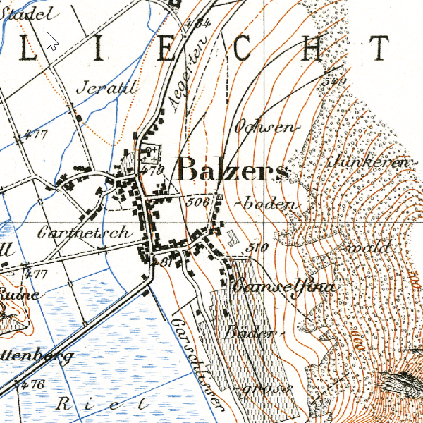
Siegfried Map 1:50,000 (1886)
With the Topographic Atlas of Switzerland 1:25,000 / 1:50,000 (Siegfried Map), the original surveys for the Dufour Map were published. It was issued between 1870 and 1926. In 1886, within the territory of Liechtenstein, only the municipality of Balzers and the Rhine were depicted.
Simple
- Date (Creation)
- 1886-01-01
- Identifier
- https://metadata.geo.llv.li/1bc94207-9fab-4bcc-8905-00ca5da3d717
- Purpose
-
Historical map, historical development
- Status
- Obsolete
Publisher
- Hours of service
-
8:00-11:30 und 13:30-17:00
- Spatial representation type
- Grid
Spatial resolution
- Spatial resolution
- 0.5 m
- Topic category
-
- A Imagery base maps earth cover
Extent
Extent
- Description
-
Liechtenstein
))

- Maintenance and update frequency
- Unknown
- geocat.ch
-
-
OpenData
-
historic map
-
national map
-
- GEMET
-
-
historical evolution
-
Infrastructure for spatial information in Europe
-
- GEMET - INSPIRE themes, version 1.0
-
-
Land cover
-
- Räumlicher Anwendungsbereich
-
-
National
-
- geocat.ch
-
-
topography
-
- GEMET
-
-
map chart
-
Resource constraints
- Use limitation
-
No Conditions Apply
- Access constraints
- Other restrictions
- Use constraints
- Other restrictions
- Other constraints
- No limitations to public access
Resource constraints
- Access constraints
- Other restrictions
- Use constraints
- Other restrictions
- Other constraints
- No conditions to access and use
- Other constraints
- Opendata BY: Open use. Must provide the source.
- Language
- Deutsch
- Character encoding
- UTF8
- Subtopic Category
- A1 Base Maps, Landscape Models
- Attribute description
- RGB-Farbwert
- Distribution format
-
-
Tagged Image File Format (TIFF)
-
Point of contact
- Hours of service
-
8:00-11:30 und 13:30-17:00
- Hierarchy level
- Dataset
Report
Result
- Title
-
VERORDNUNG (EG) Nr. 1089/2010 DER KOMMISSION vom 23. November 2010 zur Durchführung der Richtlinie 2007/2/EG des Europäischen Parlaments und des Rates hinsichtlich der Interoperabilität von Geodatensätzen und -diensten
- Date (Creation)
- 2010-08-18
- Explanation
-
nicht geprüft
- Pass
- false
- Statement
-
Auswertung aus photogrammetrischer Befliegung
- Hierarchy level
- Dataset
- Number of dimensions
- 2
- Cell geometry
- Area
- Transformation parameter availability
- 1
- Reference system identifier
- http://www.opengis.net/def/crs/EPSG/0/2056
- Maintenance and update frequency
- As needed
Metadata
- Metadata identifier
- 1bc94207-9fab-4bcc-8905-00ca5da3d717
- Language
- Deutsch
- Character encoding
- UTF8
- Language
- Français
- Character encoding
- UTF8
- Language
- Italiano
- Character encoding
- UTF8
- Language
- English
- Character encoding
- UTF8
Point of contact
- Hours of service
-
8:00-11:30 und 13:30-17:00
Type of resource
- Resource scope
- Dataset
- Metadata linkage
-
https://www.geocat.ch/geonetwork/srv/api/records/1bc94207-9fab-4bcc-8905-00ca5da3d717
- Date info (Creation)
- 2025-10-20T13:01:47.928Z
- Date info (Revision)
- 2026-04-13T09:31:43.102704Z
Metadata standard
- Title
-
eCH-0271