geocat.ch
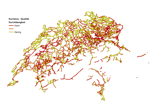
Quality of the potential corridors between protected sites for open-land wetland species (OFG-Arten)
This data set describes the quality of potential movement corridors for open wetland species (OFG species) between nationally and regionally inventoried wetlands.
This map is based on a landscape model that is categorized according to its suitability as a habitat for OFG species. Water edges and humid areas were assigned a high suitability and therefore low effort for dispersal. This suitability dataset was then used to calculate the most direct ‘least cost path’ between wetlands for the dispersal of OFG species.
The related ‘Corridor zones’ dataset supplements the idealized least-cost paths from this layer with error bars, providing spatial definition to the potential migratory routes. Together, the two maps highlight and rank potential routes between protected wetland sites according to their permeability, allowing spatially-explicit prioritization of re-wetting initiatives.
The least-cost paths are ranked according to their permeability, as measured by the total cost of movement along a path divided by the euclidean distance between the linked wetlands (Table column: 'Cost_to_EucDist_Ratio'). Red lines have a high permeability, or low cost to distance ratio, while orange lines have medium permeability, and yellow lines low. The ranking into the three categories is based on quantiles, i.e. red lines represent the 33% of least-cost-paths with the highest permeability.
For more details about the construction and application of the corridor maps, see:
Churko, G., Walter, T., Szerencsits, E., & Gramlich, A. (2020). Improving wetland connectivity through the promotion of wet arable land. Wetlands Ecology and Management, 28(4), 667–680.
Churko, Greg, Szerencsits, Erich, Gramlich, Anja, Prasuhn, Volker, & Walter, Thomas. (2018). Arten der Feucht-(Acker-) Flächen in der Schweiz und Korridore zwischen Schutzobjekten. Agroscope Science, 76, 1–39.
Roberti G., Gramlich A., Benz R., Szerencsits E., Churko G., Prasuhn V., Leifeld J., Zorn A., Jacot-Ammann K., Herzog F., Fabian Y.
Entscheidungshilfe für feuchte und nasse Ackerflächen : Unterstützung bei der Identifikation von Flächen, auf denen Alternativen zur Entwässerung in Betracht zu ziehen sind. Agroscope Transfer, 449, 2022, 1-68.
Simple
- Alternate title
-
Wetland Corridors – Quality
- Date (Publication)
- 2024-02-23
- Identifier
- PKQOFG
Principal investigator
- Status
- Completed
Point of contact
- Spatial representation type
- Vector
Spatial resolution
- Spatial resolution
- 50 m
- Topic category
-
- G Biota
Extent
Extent
- Description
-
Switzerland
))

- Maintenance and update frequency
- Not planned
Resource format
- Title
-
ESRI File Geodatabase FileGDB (GDB)
- Date
Resource format
- Title
-
OGC Geopackage (GPKG)
- Date
Resource format
- Title
-
ESRI File Geodatabase FileGDB (GDB)
- Date
- geocat.ch
-
-
opendata.swiss
-
confederation
-
biodiversity
-
- GEMET themes
-
-
agriculture
-
natural areas, landscape, ecosystems
-
- GEMET
-
-
nature conservation
-
agriculture
-
Resource constraints
Associated resource
- Title
-
-- Bezeichnung gemäss: «Bezeichnung GeoIV» (in GeoIV Anhang 1, Spalte B) --
- Association Type
- Reference to a master resource of which this one is a part
- Language
- Deutsch
- Character encoding
- UTF8
- Basic Geodata
- false
- Basic Geodata Legal Level
- Federal
- Basic Geodata Type
- openData
- Distribution format
-
-
ESRI File Geodatabase FileGDB (GDB)
-
OGC Geopackage (GPKG)
-
Owner
- OnLine resource
-
STAC Browser
- OnLine resource
- OnLine resource
-
ch.agroscope.Korridore_Qualität
WMS-FSDI service, layer "Corridor quality"
- OnLine resource
-
ch.agroscope.Korridore_Qualität
WMTS-FSDI service, layer "Corridor quality"
Digital transfer options
- OnLine resource
-
Churko et al. Wetland coridors
Literature describing the data
Digital transfer options
- OnLine resource
-
Churko_2020_Supplement_Geodata.pdf
List with basic data
Digital transfer options
- OnLine resource
-
WetlandCorridors_data_description.pdf
additional data description
Digital transfer options
- OnLine resource
-
Internetseite Feuchtackerprojekt
Link to the project
Digital transfer options
- OnLine resource
-
Korridore_Qualität.png
German legend
Digital transfer options
- OnLine resource
-
Legende_Corridors_Qualite_fr.png
French Legend
Digital transfer options
- OnLine resource
-
Churko_2021_speciesDiversity
Additional literature
- Geometric object type
- Curve
- Reference system identifier
- LV95 EPSG:2056
- Maintenance and update frequency
- As needed
Metadata
- Metadata identifier
- 136c4bee-fd84-429d-81a4-6a334c145850
- Language
- Deutsch
- Character encoding
- UTF8
- Language
- Français
- Character encoding
- UTF8
- Language
- Italiano
- Character encoding
- UTF8
- Language
- English
- Character encoding
- UTF8
- Language
- Rumantsch
- Character encoding
- UTF8
Owner
Type of resource
- Resource scope
- Dataset
- Metadata linkage
-
https://www.geocat.ch/geonetwork/srv/api/records/136c4bee-fd84-429d-81a4-6a334c145850
- Date info (Creation)
- 2024-03-21T09:35:46.809Z
- Date info (Revision)
- 2026-06-10T11:17:41.770122Z
Metadata standard
- Title
-
eCH-0271