geocat.ch
VECTOR25 Gebäude
VECTOR25 Bâtiments
VECTOR25 Edifici
VECTOR25 Buildings
VECTOR25 Edifizis
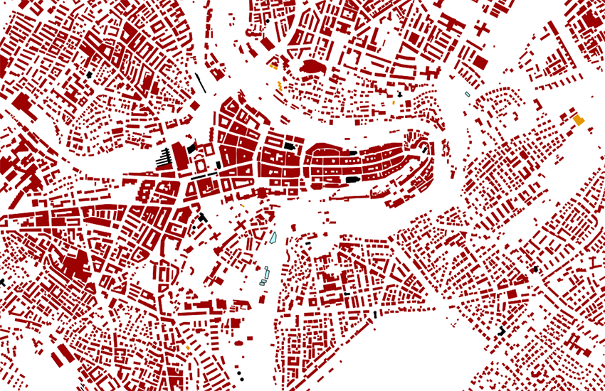
Die Ebene Gebäude (Abkürzung geb) beschreibt alle Gebäudeinformationen der Landeskarte 1:25'000 als Flächenobjekte. Die Klassierung umfasst alle Objektarten, die aufgrund der Kartenlegende klar identifiziert werden können.
La couche Bâtiments (abréviation geb) comprend l'ensemble des bâtiments figurant sur la carte nationale 1:25'000. La classification des bâtiments, représentés sous forme de surfaces, correspond aux catégories d'objets figurant sur la légende de la carte
Il livello Edifici (abbreviazione geb) comprende tutte le informazioni sugli edifici della Carta nazionale 1:25'000 come oggetti di superficie. La classificazione comprende tutti i tipi di oggetti che possono essere chiaramente identificati in base alla legenda della carta.
The layer buildings (abbrev "geb") contains all of the "building data" of the National Map 1:25 000 as surface objects. The classification includes all of the object types which could be identified on the basic of the map legend.
Il plaun Edifizis (abreviaziun geb) dat tut las infurmaziuns davart ils edifizis che figureschan sin la Charta naziunala 1:25'000. La classificaziun dals edifizis, represchentads sco objects da surfatscha, cumpiglia tut las categorias d'objects che figureschan sin la legenda da la charta.
Simple
-
Autre titreAltri nomi o acronimiAlternate titleAlternate titleAlternativtitel
-
Gebäude VECTOR25
Bâtiments VECTOR25
Edifici VECTOR25
Buildings VECTOR25
Edifizis VECTOR25
-
Date (Publication)Data (Pubblicazione)Date (Publication)Date (Publication)Datum (Publikation)
- 2008-08-31
-
IdentifiantIdentificatoreIdentifierIdentifierKennung
- ch.swisstopo.vec25-gebaeude
-
Autres informations de référenceAltre informazioni di riferimentoOther citation detailsOther citation detailsWeitere Referenzinformationen
-
Teil des VECTOR25 Datensatzes
Fait partie du jeux de données VECTOR25
Part of the vECTOR25 Dataset
-
ÉtatStatoStatusStatusBearbeitungsstatus
-
TerminéCompletatoCompletedCompletedAbgeschlossen
Point de contact
Punto di contatto
Point of contact
Point of contact
Ansprechpartner
-
Type de représentation spatialeTipo di rappresentazione spazialeSpatial representation typeSpatial representation typeRäumliche Darstellungsart
-
vecteurVettorialeVectorVectorVektor
Résolution spatiale
Risoluzione spaziale
Spatial resolution
Spatial resolution
Räumliche Auflösung
Fraction représentative
Frazione rappresentativa
Equivalent scale
Equivalent scale
Vergleichsmassstab
-
DénominateurDenominatoreDenominatorDenominatorMassstabszahl
- 25000
-
Catégorie de thèmeCategoria ISOTopic categoryTopic categoryThematik
-
-
O StructureO StrutturaO StructureO StructureO Bauwerke
-
Étendue
Estensione
Extent
Extent
Ausdehnung
Étendue
Estensione
Extent
Extent
Ausdehnung
-
DescriptionDescrizioneDescriptionDescriptionBeschreibung
-
National Map 1:25'000
Landeskarte 1:25'000
Carte nationale 1:25'000
Carta nazionale 1:25'000
-
Identifiant géographiqueIdentificatore geograficoGeographic identifierGeographic identifierGeografische Kennung
- NM25LK25CN25CN25CN25
))

-
Fréquence de mise à jourFrequenza di aggiornamentoMaintenance and update frequencyMaintenance and update frequencyWartungsintervall
-
Non planifiéeNon pianificatoNot plannedNot plannedNicht geplant
-
NiveauLivelloHierarchy levelHierarchy levelBezugsebene
-
Jeu de donnéesSet di datiDatasetDatasetDatenbestand
-
Remarque sur la mise à jourNota sull'aggiornamentoMaintenance noteMaintenance noteAnmerkung
-
Wird seit 2008 nicht mehr nachgeführt
N’est plus mis à jour depuis 2008
Since 2008 not updated anymore
Format de la ressource
Formato della risorsa
Resource format
Resource format
Format der Ressource
-
TitreTitoloTitleTitleTitel
-
ESRI ArcInfo coverage (COV)
-
DateDataDateDateDatum
- geocat.ch
-
-
château
castello
castle
-
e-geo.ch
e-geo.ch
e-geo.ch
-
modèle du territoire
modello del territorio
landscape model
-
SIG (Système d'Information Géographique)
SIG (Sistema Informativo Geografico)
GIS (Geographic Information System)
-
- GEMET
-
-
église
chiesa
church
-
système d'information géographique
sistema informativo geografico
geographic information system
-
- GEMET - INSPIRE themes, version 1.0
-
-
Bâtiments
Edifici
Buildings
-
- geocat.ch
-
-
BGDI Bundesgeodaten-Infrastruktur
IFDG l’Infrastructure Fédérale de données géographiques
IFDG Infrastruttura federale dei dati geografici
FSDI Federal Spatial Data Infrastructure
-
Contraintes sur la ressource
Vincoli sulle risorse
Resource constraints
Resource constraints
Ressourcenbeschränkungen
-
Contraintes d'utilisationVincoli d'usoUse constraintsUse constraintsNutzungseinschränkungen
-
LicenceLicenzaLicenseLicenseLizenz
Ressource associée
Risorsa associata
Associated resource
Associated resource
Verlinkte Ressource
-
Type d'associationTipo di associazioneAssociation TypeAssociation TypeAssoziationstyp
-
Citation de travail plus largeCitazione di un'opera più ampiaReference to a master resource of which this one is a partReference to a master resource of which this one is a partÜbergeordneter Datenbestand
-
Metadata ReferenceRiferimento metadatiMetadata ReferenceMetadata ReferenceMetadatenreferenz
Ressource associée
Risorsa associata
Associated resource
Associated resource
Verlinkte Ressource
-
TitreTitoloTitleTitleTitel
-
Topografisches Landschaftsmodell (Landesvermessung)
Modèle topographique du paysage (mensuration nationale)
Modello topografico del paesaggio (misurazione nazionale)
-
Type d'associationTipo di associazioneAssociation TypeAssociation TypeAssoziationstyp
-
Citation de travail plus largeCitazione di un'opera più ampiaReference to a master resource of which this one is a partReference to a master resource of which this one is a partÜbergeordneter Datenbestand
-
LangueLinguaLanguageLanguageSprache
- Deutsch
-
Encodage de caractèresCodifica dei caratteriCharacter encodingCharacter encodingZeichenkodierung
-
Utf8UTF8UTF8UTF8Utf8
-
LangueLinguaLanguageLanguageSprache
- English
-
Encodage de caractèresCodifica dei caratteriCharacter encodingCharacter encodingZeichenkodierung
-
Utf8UTF8UTF8UTF8Utf8
-
Description de l'environnement de travailDescrizione dell'ambiente di lavoroEnvironment descriptionEnvironment descriptionBeschreibung der Arbeitsumgebung
-
ARC/INFO
ARC/INFO
-
Informations supplémentairesInformazioni supplementariSupplemental InformationSupplemental InformationZusätzliche Informationen
-
Die Ebenen Strassennetz, Eisenbahnnetz, Übriger Verkehr, Gewässernetz, Primärflächen, Gebäude, Hecken und Bäume, Anlagen und Einzelobjekte bilden zusammen den Datensatz VECTOR25.
Les couches Réseau routier, Réseau ferroviaire, Autres moyens de transport, Réseau hydrographique, Surfaces primaires, Bâtiments,Haies et arbres isolés, Surfaces aménagées et Objets isolés forment ensemble le jeu de données VECTOR25.
The layers Road network, Railway network, Other traffic, Hydrographic network, Primary surfaces, Buildings, Hedges and trees, Functional surfaces and Single objects build together the dataset VECTOR25.
-
Conformité à ISO 19110Conformità alla norma ISO 19110Compliance codeCompliance codeKonformität mit ISO 19110
- 0
-
LangueLinguaLanguageLanguageSprache
- Deutsch
-
LangueLinguaLanguageLanguageSprache
- Français
-
Livré avec jeu de donnéesFornito con set di datiIncluded with datasetIncluded with datasetMit Datensatz geliefert
- 0
-
TitreTitoloTitleTitleTitel
-
VECTOR25 Das digitale Lanschaftsmodell der Schweiz : Produkteinformation
VECTOR25 Le modèle numérique du territoire de la Suisse : Information de produit
-
Date (Publication)Data (Pubblicazione)Date (Publication)Date (Publication)Datum (Publikation)
- 2007-06-01
-
Forme de la présentationForma della presentazionePresentation formPresentation formPräsentationsform
-
Document numériqueDocumento digitaleDigital documentDigital documentDigitales Dokument
-
Format de distributionFormato (codifica)Distribution formatDistribution formatAbgabeformat
-
-
AutoCAD DXF (DXF)
-
ESRI Shapefile (SHP)
-
Options de transfert numérique
Opzioni di trasferimento digitale
Digital transfer options
Digital transfer options
Optionen für die digitale Übertragung
-
Ressource en ligneRisorsa onlineOnLine resourceOnLine resourceOnline
-
Vorschau map.geo.admin.ch
Vorschau map.geo.admin.chAperçu map.geo.admin.chPrevisione map.geo.admin.chPreview map.geo.admin.ch
Options de transfert numérique
Opzioni di trasferimento digitale
Digital transfer options
Digital transfer options
Optionen für die digitale Übertragung
-
Ressource en ligneRisorsa onlineOnLine resourceOnLine resourceOnline
-
ch.swisstopo.vec25-gebaeude
WMS-BGDI Dienst, Layer "Gebäude VECTOR25"Service WMS-IFDG, couche "Bâtiments VECTOR25"Servizio WMS-IFDG, strato "Edifici VECTOR25"WMS-FSDI service, layer "Buildings VECTOR25"WMS-BGDI Dienst, Layer "Gebäude VECTOR25"
Options de transfert numérique
Opzioni di trasferimento digitale
Digital transfer options
Digital transfer options
Optionen für die digitale Übertragung
-
Ressource en ligneRisorsa onlineOnLine resourceOnLine resourceOnline
-
ch.swisstopo.vec25-gebaeude
WMTS-BGDI Dienst, Layer "Gebäude VECTOR25"Service WMTS-IFDG, couche , Layer "Bâtiments VECTOR25"Servizio WMTS-IFDG, strato "Edifici VECTOR25"WMTS-FSDI service, layer "Buildings VECTOR25"WMTS-BGDI Dienst, Layer "Gebäude VECTOR25"
Options de transfert numérique
Opzioni di trasferimento digitale
Digital transfer options
Digital transfer options
Optionen für die digitale Übertragung
Options de transfert numérique
Opzioni di trasferimento digitale
Digital transfer options
Digital transfer options
Optionen für die digitale Übertragung
-
Ressource en ligneRisorsa onlineOnLine resourceOnLine resourceOnline
-
RESTful API von geo.admin.ch
RESTful API von geo.admin.chRESTful API de geo.admin.chRESTful API da geo.admin.chRESTful API from geo.admin.chRESTful API dad geo.admin.ch
-
Généralités sur la provenanceInformazioni generali sulla provenienzaStatementStatementErklärung
-
Inhaltlich und geometrisch auf der Landeskarte 1:25'000 basiert. Lagegenauigkeit: 3-8 M.
Se base sur le contenu et la géométrie de la carte nationale suisse au 1:25'000. Précision de position : 3 - 8 m.
Content and geometry based on the swiss National Map 1:25'000. Geometric precision : 3-8 m.
-
NiveauLivelloHierarchy levelHierarchy levelBezugsebene
-
Jeu de donnéesSet di datiDatasetDatasetDatenbestand
-
Niveau de topologieLivello di topologiaTopology levelTopology levelTopologieebene
-
Topologie de réseau complèteGrafo planare completoFull planar graphFull planar graphVollständige Netzwerktopologie
-
Type d’objet géométriqueTipo di oggetto geometricoGeometric object typeGeometric object typeTyp des geometrischen Objekts
-
PolygoneSuperficieSurfaceSurfacesurface
-
Nombre d’objets géométriquesNumero di oggetti geometriciGeometric object countGeometric object countAnzahl geometrischer Objekte
- 2100000
-
Type d’objet géométriqueTipo di oggetto geometricoGeometric object typeGeometric object typeTyp des geometrischen Objekts
-
LigneCurvaCurveCurvecurve
-
Nombre d’objets géométriquesNumero di oggetti geometriciGeometric object countGeometric object countAnzahl geometrischer Objekte
- 2100000
-
Nom du système de référenceNome del sistema di riferimentoReference system identifierReference system identifierName des Referenzsystems
- EPSG:21781
-
Fréquence de mise à jourFrequenza di aggiornamentoMaintenance and update frequencyMaintenance and update frequencyWartungsintervall
-
Comme nécessaireSecondo necessitàAs neededAs neededBei Bedarf
Metadata
-
Identifiant des métadonnéesIdentificativo della schedaMetadata identifierMetadata identifierIdentifikator des Metadatensatzes
- 112c4f0e-0755-44bb-bdb0-249e9c56f8bb
-
LangueLinguaLanguageLanguageSprache
- Deutsch
-
Encodage de caractèresCodifica dei caratteriCharacter encodingCharacter encodingZeichenkodierung
-
Utf8UTF8UTF8UTF8Utf8
-
LangueLinguaLanguageLanguageSprache
- Français
-
Encodage de caractèresCodifica dei caratteriCharacter encodingCharacter encodingZeichenkodierung
-
Utf8UTF8UTF8UTF8Utf8
-
LangueLinguaLanguageLanguageSprache
- Italiano
-
Encodage de caractèresCodifica dei caratteriCharacter encodingCharacter encodingZeichenkodierung
-
Utf8UTF8UTF8UTF8Utf8
-
LangueLinguaLanguageLanguageSprache
- English
-
Encodage de caractèresCodifica dei caratteriCharacter encodingCharacter encodingZeichenkodierung
-
Utf8UTF8UTF8UTF8Utf8
-
LangueLinguaLanguageLanguageSprache
- Rumantsch
-
Encodage de caractèresCodifica dei caratteriCharacter encodingCharacter encodingZeichenkodierung
-
Utf8UTF8UTF8UTF8Utf8
Point de contact
Punto di contatto
Point of contact
Point of contact
Ansprechpartner
-
Heures de serviceOrario di servizioHours of serviceHours of serviceBetriebszeiten
-
08h30 - 11h00 / 14h00 - 16h00 GMT+1
Type de ressource
Tipo di risorsa
Type of resource
Type of resource
Anwendungsbereich der Metadaten
-
Domaine d'application de la ressourceAmbito di applicazione della risorsaResource scopeResource scopeDomäne der Ressourcenanwendung
-
Jeu de donnéesSet di datiDatasetDatasetDatenbestand
-
NomNomeNameNameName
-
Layer
-
Lien vers la métadonnéeCollegamento ai metadatiMetadata linkageMetadata linkageLink zu den Metadaten
-
Informations de date (Création)Informazioni sulla data (Creazione)Date info (Creation)Date info (Creation)Datumsangaben (Erstellung)
- 2007-12-17T12:00:00Z
-
Informations de date (Révision)Informazioni sulla data (Revisione)Date info (Revision)Date info (Revision)Datumsangaben (Aktualisierung)
- 2026-04-13T09:45:24.802715Z
Norme des métadonnées
Standard dei metadati
Metadata standard
Metadata standard
Metadatenstandard
-
TitreTitoloTitleTitleTitel
-
eCH-0271