geocat.ch
Raumbezogene statistische Grundeinheiten (USPAT)
Unités spatiales statistiques de base (USPAT)
Unità territoriali statistiche di base (USPAT)
Basic spatial statistical units (USPAT)
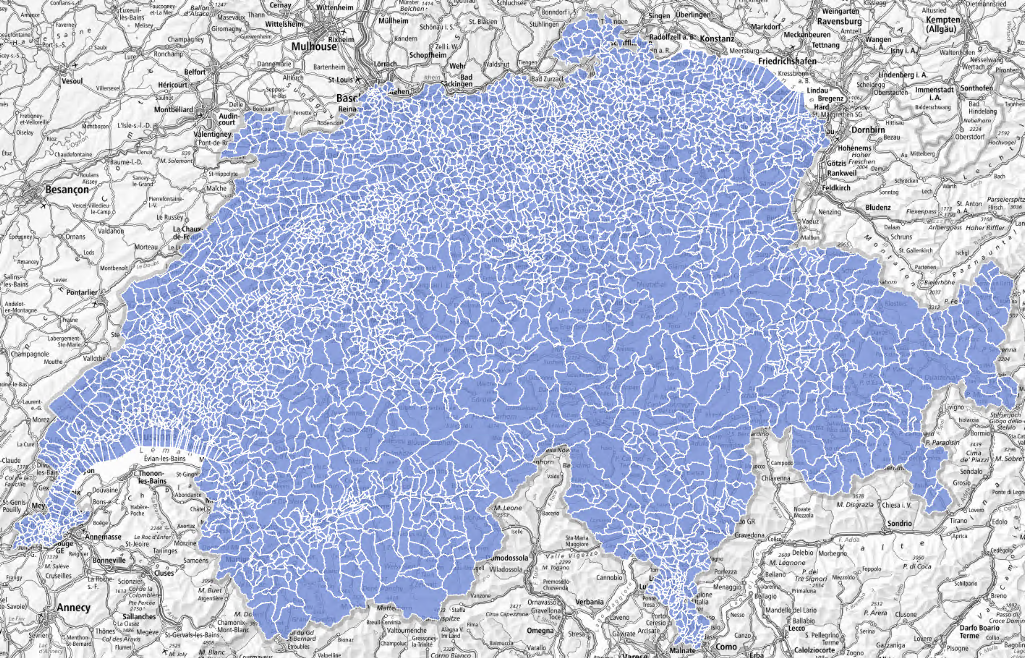
Das BFS hat raumbezogene statistische Grundeinheiten (USPAT) entwickelt, mit denen die Schweizer Landesfläche in rund 3600 über die aktuellen Gemeindegrenzen hinaus gruppierbare Einheiten unterteilt wird. Sie sind so aufgebaut, dass sie auch bei Gemeindefusionen zeitlich stabil sind. Basierend auf diesen Einheiten lassen sich Statistiken produzieren, die detaillierte Analysen sowohl ländlicher als auch städtischer Gebiete ermöglichen. Diese kleinen Einheiten werden so gruppiert, dass sie schweizweit etwa 750 grössere Raumeinheiten mit je rund 10 000 Einwohnerinnen und Einwohnern bilden und ein umfangreicheres Statistikangebot gewährleisten als auf Gemeindeebene.
L’OFS a développé des unités spatiales statistiques de base (USPAT) qui découpent le territoire suisse en environ 3600 entités. Ces unités spatiales de premier niveau (USPAT1) peuvent être agrégées sur les limites des communes actuelles. Les USPAT1 ont été développées pour être stables dans le temps et éviter les modifications de périmètres résultants des fusions de communes. Les statistiques produites à ce niveau permettent une analyse fine du territoire, autant en zone rurale qu’en région urbaine. Les USPAT1 peuvent être regroupées afin de disposer pour l’ensemble du territoire de quelque 750 unités spatiales de niveau secondaire (USPAT2) de plus grande taille. Ces dernières regroupent environ 10 000 personnes chacune et permettent d'étoffer l'offre par des informations statistiques qui ne sont pas disponibles pour les communes de petite taille.
L'UST ha sviluppato unità territoriali statistiche di base (USPAT), che dividono il territorio svizzero in circa 3600 entità che possono essere raggruppate lungo i confini dei Comuni esistenti. Tali unità sono state concepite per essere stabili nel tempo, nonostante le fusioni di comuni. Le statistiche prodotte a questo livello consentono un'analisi dettagliata del territorio sia nelle aree rurali che in quelle urbane. Queste piccole unità sono raggruppate per fornire un totale di circa 750 unità spaziali più grandi, ciascuna con circa 10 000 abitanti, per fornire una gamma di statistiche più completa rispetto al livello comunale.
The FSO has developed basic spatial statistical units (USPAT), which divide the Swiss territory into around 3 600 entities that can be grouped together along the boundaries of existing communes. They are designed to be stable over time, despite mergers of municipalities. The statistics produced at this level will enable a detailed analysis of the territory in both rural and urban areas. These small units are grouped together to provide a total of about 750 larger spatial units, each with around 10 000 inhabitants, to provide a more comprehensive range of statistics than at municipal level.
Simple
-
Date (Publication)Data (Pubblicazione)Date (Publication)Date (Publication)Datum (Publikation)
- 2024-06-28
-
IdentifiantIdentificatoreIdentifierIdentifierKennung
- ch.bfs.uspat
-
ÉtatStatoStatusStatusBearbeitungsstatus
-
TerminéCompletatoCompletedCompletedAbgeschlossen
Point de contact
Punto di contatto
Point of contact
Point of contact
Ansprechpartner
-
Catégorie de thèmeCategoria ISOTopic categoryTopic categoryThematik
-
-
D LimitesD ConfiniD BoundariesD BoundariesD Grenzen
-
Étendue
Estensione
Extent
Extent
Ausdehnung
Étendue
Estensione
Extent
Extent
Ausdehnung
-
DescriptionDescrizioneDescriptionDescriptionBeschreibung
-
Switzerland
Schweiz
Suisse
Svizzera
Svizra
))

-
Fréquence de mise à jourFrequenza di aggiornamentoMaintenance and update frequencyMaintenance and update frequencyWartungsintervall
-
IrrégulièreIrregolareIrregularIrregularUnregelmässig
-
Durée de conservationDurata di conservazioneDuration of ConservationDuration of ConservationAufbewahrungsdauer NV in Jahren
- 100
-
Évaluation de la valeur archivistiqueValutazione del valore archivisticoAppraisal of Archival ValueAppraisal of Archival ValueBewertung Archivwürdigkeit
-
NNNNN
Format de la ressource
Formato della risorsa
Resource format
Resource format
Format der Ressource
-
TitreTitoloTitleTitleTitel
-
OGC Geopackage (GPKG)
-
DateDataDateDateDatum
Format de la ressource
Formato della risorsa
Resource format
Resource format
Format der Ressource
-
TitreTitoloTitleTitleTitel
-
ESRI Shapefile (SHP)
-
DateDataDateDateDatum
- Keywords
-
-
Statistik; Grundeinheit
statistique; unités de base
-
- geocat.ch
-
-
opendata.swiss
opendata.swiss
opendata.swiss
opendata.swiss
-
ligne de frontières
linea di confine
boundary line
-
confédération
confederazione
confederation
-
Utilisation spécifique de la ressource
Utilizzo specifico della risorsa
Resource specific usage
Resource specific usage
Spezifische Verwendung der Ressource
-
UtilisationUtilizzoSpecific usageSpecific usageVerwendung
-
Kommerzielle Verwendung nur mit separater Vereinbarung
Utilisation commerciale uniquement avec un accord distinct.
Contraintes sur la ressource
Vincoli sulle risorse
Resource constraints
Resource constraints
Ressourcenbeschränkungen
-
Autres contraintesAltri vincoliOther constraintsOther constraintsAndere Einschränkungen
- Opendata OPEN BY: Freie Nutzung. Quellenangabe ist Pflicht.Opendata OPEN BY: Utilisation libre. Obligation d’indiquer la source.Opendata OPEN BY: Libero utilizzo. Indicazione della fonte obbligatoria.Opendata OPEN BY: Open use. Must provide the source.
-
LangueLinguaLanguageLanguageSprache
- Deutsch
-
Encodage de caractèresCodifica dei caratteriCharacter encodingCharacter encodingZeichenkodierung
-
Utf8UTF8UTF8UTF8Utf8
-
Géodonnées de baseGeodati di baseBasic GeodataBasic GeodataGeobasisdaten
- false
-
Niveau des géodonnées de baseLivello legale dei geodati di baseBasic Geodata Legal LevelBasic Geodata Legal LevelGeobasisdatenebene
-
FédéralFederaleFederalFederalNational
-
Format de distributionFormato (codifica)Distribution formatDistribution formatAbgabeformat
-
-
ESRI Shapefile (SHP)
-
OGC Geopackage (GPKG)
-
Options de transfert numérique
Opzioni di trasferimento digitale
Digital transfer options
Digital transfer options
Optionen für die digitale Übertragung
-
Ressource en ligneRisorsa onlineOnLine resourceOnLine resourceOnline
-
Datenbeschreibung
Options de transfert numérique
Opzioni di trasferimento digitale
Digital transfer options
Digital transfer options
Optionen für die digitale Übertragung
-
Ressource en ligneRisorsa onlineOnLine resourceOnLine resourceOnline
-
GEOSTAT
GEOSTAT ist das BFS-Kompetenzzentrum für Geoinformation und digitale Bildverarbeitung.GEOSTAT est le centre de compétence pour la géoinformation et le traitement numérique des images digitales de l'OFS.
Options de transfert numérique
Opzioni di trasferimento digitale
Digital transfer options
Digital transfer options
Optionen für die digitale Übertragung
-
Ressource en ligneRisorsa onlineOnLine resourceOnLine resourceOnline
-
Variablenliste
I14Y-InteroperabilitätsplattformI14Y Plateforme d’interopérabilitéI14Y Piattaforma di interoperabilitàI14Y Interoperability platform
Options de transfert numérique
Opzioni di trasferimento digitale
Digital transfer options
Digital transfer options
Optionen für die digitale Übertragung
Options de transfert numérique
Opzioni di trasferimento digitale
Digital transfer options
Digital transfer options
Optionen für die digitale Übertragung
-
Ressource en ligneRisorsa onlineOnLine resourceOnLine resourceOnline
-
USPAT1 Geodaten (GeoPackage, Shapefile)
-
Type d’objet géométriqueTipo di oggetto geometricoGeometric object typeGeometric object typeTyp des geometrischen Objekts
-
PolygoneSuperficieSurfaceSurfacesurface
-
Nom du système de référenceNome del sistema di riferimentoReference system identifierReference system identifierName des Referenzsystems
- EPSG:2056
Metadata
-
Identifiant des métadonnéesIdentificativo della schedaMetadata identifierMetadata identifierIdentifikator des Metadatensatzes
- 0fc42082-e42c-4e25-a89f-b998981ccd19
-
LangueLinguaLanguageLanguageSprache
- Deutsch
-
Encodage de caractèresCodifica dei caratteriCharacter encodingCharacter encodingZeichenkodierung
-
Utf8UTF8UTF8UTF8Utf8
-
LangueLinguaLanguageLanguageSprache
- Français
-
Encodage de caractèresCodifica dei caratteriCharacter encodingCharacter encodingZeichenkodierung
-
Utf8UTF8UTF8UTF8Utf8
-
LangueLinguaLanguageLanguageSprache
- Italiano
-
Encodage de caractèresCodifica dei caratteriCharacter encodingCharacter encodingZeichenkodierung
-
Utf8UTF8UTF8UTF8Utf8
-
LangueLinguaLanguageLanguageSprache
- English
-
Encodage de caractèresCodifica dei caratteriCharacter encodingCharacter encodingZeichenkodierung
-
Utf8UTF8UTF8UTF8Utf8
-
LangueLinguaLanguageLanguageSprache
- Rumantsch
-
Encodage de caractèresCodifica dei caratteriCharacter encodingCharacter encodingZeichenkodierung
-
Utf8UTF8UTF8UTF8Utf8
Dépositaire
Custode
Custodian
Custodian
Verwalter
-
Lien vers la métadonnéeCollegamento ai metadatiMetadata linkageMetadata linkageLink zu den Metadaten
-
Informations de date (Création)Informazioni sulla data (Creazione)Date info (Creation)Date info (Creation)Datumsangaben (Erstellung)
- 2024-07-02T08:06:44.505Z
-
Informations de date (Révision)Informazioni sulla data (Revisione)Date info (Revision)Date info (Revision)Datumsangaben (Aktualisierung)
- 2026-08-14T13:32:11.624688Z
Norme des métadonnées
Standard dei metadati
Metadata standard
Metadata standard
Metadatenstandard
-
TitreTitoloTitleTitleTitel
-
eCH-0271