geocat.ch
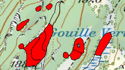
Inventaire fédéral des hauts-marais d'importance nationale (VS)
Les tourbières comptent parmi les milieux naturels les plus sensibles de Suisse. Ils sont fortement en recul: seuls 10 à 20% du nombre initial subsistent aujourd'hui. L'inventaire scientifique des tourbières a été effectué entre 1978 et 1984 par la division Paysage du WSL (Institut fédéral de recherches sur la forêt, la neige et le paysage) sur mandat de Pro Natura Helvetica. Conformement à l'art. 18a de la loi fédérale du 1er juillet 1966 sur la protection de la nature et du paysage (LPN), entrée en vigueur le 1er février 1988, le Conseil fédéral, après avois pris l'avis des cantons, désigne les biotopes d'importance nationale, détermine leur situation et précise les objectifs visés par la protection.Le premier inventaire fédéral selon l'art. 18a LPN fut celui des hauts-marais et marais de transition, entré en vigueur en 1991. Il comportait 514 objets à l'origine; après avoir été complété par une deuxième série en 2003 et révisé en 2007, il compte désormais 545 objets.
Simple
- Alternate title
-
Hauts-marais (VS)
- Date (Revision)
- 2017-11-01
- Identifier
- 105
- Purpose
-
Avec l’ordonnance, les derniers hauts-marais suisses existants sont sous protection.
- Status
- Completed
Custodian
- Spatial representation type
- Vector
Spatial resolution
Equivalent scale
- Denominator
- 25000
- Topic category
-
- L Environment
Extent
Extent
- Description
-
Canton of Valais (VS)
))

- Maintenance and update frequency
- Not planned
Resource format
- Title
-
ESRI Enterprise Geodatabase
- Date
- GEMET - INSPIRE themes, version 1.0
-
-
Habitats and biotopes
-
- geocat.ch
-
-
raised bog
-
official geodata
-
- GEMET
-
-
bog
-
swamp
-
Resource constraints
- Use limitation
-
Aucune
Resource constraints
- Access constraints
- Other restrictions
- Other constraints
-
Géodonnées accessibles au public (niveau A selon l'OGéo)
- Other constraints
-
Les conditions générales d'utilisation des géodonnées du Canton du Valais font foi ( https://www.vs.ch/fr/web/guest/information-legale).
- Language
- Deutsch
- Character encoding
- UTF8
- Environment description
-
S:\Géodonnées VS\L2 Protection de la nature\Inventaire fédéral des hauts-marais et des marais de transition d_importance nationale.lyr
- Subtopic Category
- L2 Nature and Landscape Protection
- Basic Geodata
- true
- Basic Geodata ID
-
20.1
- Basic Geodata Legal Level
- Federal
- Basic Geodata Type
- basicGeodata
- Distribution format
-
-
ESRI Shapefile (SHP)
-
autres formats sur demande / andere Formate auf Anfrage
-
ArcGIS REST Feature Service
-
Distributor
Digital transfer options
- OnLine resource
-
Géoportail du Canton du Valais
Digital transfer options
- OnLine resource
-
haut_marais
Inventaire fédéral des hauts-marais d'importance nationale
- Statement
-
Les hauts-marais (tourbières) d’au moins 625 m2 de surface contiguë ont été inventoriés et cartographiés sur la base de leur flore.
- Hierarchy level
- Dataset
- Description
-
Digitalisation
- Geometric object type
- Surface
- Geometric object count
- 79
- Reference system identifier
- EPSG:2056/CH1903+_MN95
Metadata
- Metadata identifier
- 0abba544-d6b5-4e07-a6dc-43221e8cba40
- Language
- Français
- Character encoding
- UTF8
- Language
- Deutsch
- Character encoding
- UTF8
- Language
- Italiano
- Character encoding
- UTF8
- Language
- English
- Character encoding
- UTF8
- Language
- Rumantsch
- Character encoding
- UTF8
Distributor
Type of resource
- Resource scope
- Dataset
- Metadata linkage
-
https://www.geocat.ch/geonetwork/srv/api/records/0abba544-d6b5-4e07-a6dc-43221e8cba40
- Date info (Creation)
- 2014-12-16T16:14:40Z
- Date info (Revision)
- 2026-04-13T09:23:05.226026Z
Metadata standard
- Title
-
eCH-0271