geocat.ch
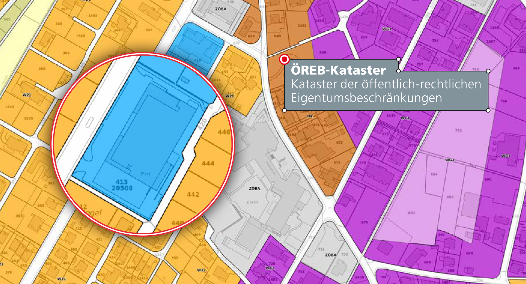
ÖREB-Kataster Fürstentum Liechtenstein
Die wichtigsten öffentlich-rechtlichen Eigentumsbeschränkungen auf einen Klick Grundlegende Informationen für alle, die ein Grundstück besitzen, ein Haus bauen möchten oder sich mit Immobilien beschäftigen.
Für die Nutzung von Grundstücken gibt es in Liechtenstein zahlreiche Gesetze, Verordnungen und behördliche Einschränkungen – die sogenannten öffentlich-rechtlichen Eigentumsbeschränkungen (ÖREB). Zonenpläne geben beispielsweise die erlaubte Bauhöhe in einer bestimmten Zone vor und Baulinienpläne legen den Mindestabstand zwischen Haus und Grundstücksgrenze fest.
Simple
-
Date (Publication)Data (Pubblicazione)Date (Publication)Datum (Publikation)
- 2021-07-01
-
IdentifiantIdentificatoreIdentifierKennung
- https://geodaten.llv.li/metadata/09d0ed3b-7bf4-4301-bb23-2027fd160ab5
-
ButScopoPurposeZweck
-
Kataster der öffentlich-rechtlichen Eigentumsbeschränkungen
-
ÉtatStatoStatusBearbeitungsstatus
-
ContinuIn corsoOn goingKontinuierliche Aktualisierung
Point de contact
Punto di contatto
Point of contact
Ansprechpartner
-
Heures de serviceOrario di servizioHours of serviceBetriebszeiten
-
8:00-11:30 und 13:30-17:00
-
Catégorie de thèmeCategoria ISOTopic categoryThematik
-
-
A Imagerie, cartes de base et occupation du solA Mappe di base con immagini della copertura terrestreA Imagery base maps earth coverA Oberflächenbeschreibung
-
E Planification et cadastreE Catasto urbanisticoE Planning cadastreE Planungsunterlagen und Kataster
-
G BioteG BiotaG BiotaG Biologie
-
I Eaux intérieuresI Acque interneI Inland watersI Binnengewässer
-
L EnvironnementL AmbienteL EnvironmentL Umwelt
-
Étendue
Estensione
Extent
Ausdehnung
Étendue
Estensione
Extent
Ausdehnung
-
DescriptionDescrizioneDescriptionBeschreibung
-
Liechtenstein
Liechtenstein
Liechtenstein
Liechtenstein
))

-
Fréquence de mise à jourFrequenza di aggiornamentoMaintenance and update frequencyWartungsintervall
-
ContinueContinuaContinualKontinuierlich
- GEMET - INSPIRE themes, version 1.0
-
-
Parcelles cadastrales
Parcelle catastali
Cadastral parcels
-
Habitats et biotopes
Habitat e biotopi
Habitats and biotopes
-
Usage des sols
Utilizzo del territorio
Land use
-
Sites protégés
Siti protetti
Protected sites
-
- GEMET themes
-
-
législation
legislazione
legislation
-
administration
amministrazione
administration
-
zones naturelles, paysages, écosystèmes
aree naturali, paesaggio, ecosistemi
natural areas, landscape, ecosystems
-
bruit, vibrations
rumore, vibrazioni
noise, vibrations
-
bâtiment
edilizia
building
-
- Räumlicher Anwendungsbereich
-
-
Nationales
Nazionali
National
-
- geocat.ch
-
-
périmètre de protection des eaux souterraines
area di protezione delle acque sotterranee
groundwater protection area
-
plan de quartier
piano di quartiere
quarter map
-
géoservice
geoservizio
geoservice
-
mensuration officielle MO
misurazione ufficiale MU
cadastral surveying
-
nature
natura
nature
-
site pollué
sito inquinato
polluted site
-
zone de protection
zona di protezione
protection zone
-
terrain
fondo
site
-
secteur de protection des eaux
settore di protezione delle acque
water protection sector
-
affectation primaire
utilizzazione di base
primary use
-
plan d'aménagement
piano d'edificabilità
development plan
-
RDPPF
RDPP
OeREB
-
-
ThèmeTemaThemeThema
-
-
Landschaft
paysage
paesaggio
landscape
-
Baugebiet
zone construite
area edificabile
building area
-
Grundwasserschutz
protection des réserves d'eau souterraines
protezione delle acque sotterranee
groundwater protection
-
Gewässer
eaux (géographie)
acque (geografia)
water (geographic)
-
Naturgebietschutz
protection des espaces naturels
protezione delle aree naturali
natural areas protection
-
Biotop
biotope
biotopo
biotope
-
Natürliche Lebensräume, Landschaft, Ökosysteme
zones naturelles, paysages, écosystèmes
aree naturali, paesaggio, ecosistemi
natural areas, landscape, ecosystems
-
Lärm, Erschütterungen
bruit, vibrations
rumore, vibrazioni
noise, vibrations
-
Gesetzgebung
législation
legislazione
legislation
-
Gebaute Umwelt
environnement bâti
ambiente costruito
built environment
-
Gebäude
bâtiment
edificio
building
-
Bauland
zone constructible
terreno fabbricabile
building land
-
Contraintes sur la ressource
Vincoli sulle risorse
Resource constraints
Ressourcenbeschränkungen
-
Limitation d'utilisationLimitazione d'usoUse limitationNutzungsbeschränkung
-
Andere Einschränkungen
-
PaysPaeseCountryStaat
-
LILILILI
-
Type de législationTipo di legislazioneLegislation TypeGesetzestyp
-
nationalLawnationalLawnationalLawnationalLaw
-
TitreTitoloTitleTitel
-
Gesetz vom 2. März 2018 über den Kataster der öffentlich-rechtlichen Eigentumsbeschränkungen
-
Date (Création)Data (Creazione)Date (Creation)Datum (Erstellung)
- 2018-07-01
-
LangueLinguaLanguageSprache
- Deutsch
-
Encodage de caractèresCodifica dei caratteriCharacter encodingZeichenkodierung
-
Utf8UTF8UTF8Utf8
-
Catégorie de sous-thèmeCategoria di sottotemaSubtopic CategoryThematische Unterkategorien
-
A1 Cartes de base, modèles de paysageA1 Mappe di base, modelli paesaggisticiA1 Base Maps, Landscape ModelsA1 Basiskarten, Landschaftsmodelle
-
Catégorie de sous-thèmeCategoria di sottotemaSubtopic CategoryThematische Unterkategorien
-
E1 Aménagement du territoire, développement spatialE1 Pianificazione territoriale, sviluppo territorialeE1 Spatial Planning, Spatial DevelopmentE1 Raumplanung, Raumentwicklung
-
Catégorie de sous-thèmeCategoria di sottotemaSubtopic CategoryThematische Unterkategorien
-
E2 Cadastre foncierE2 Catasto, Registro fondiarioE2 Cadastre, Land RegistryE2 Grundstückskataster
-
Catégorie de sous-thèmeCategoria di sottotemaSubtopic CategoryThematische Unterkategorien
-
L1 Protection de l’environnement, bruitL1 Protezione ambientale, RumoreL1 Environmental Protection, NoiseL1 Umweltschutz, Lärm
-
Catégorie de sous-thèmeCategoria di sottotemaSubtopic CategoryThematische Unterkategorien
-
L2 Protection de la nature et du paysageL2 Protezione della natura e del paesaggioL2 Nature and Landscape ProtectionL2 Natur- und Landschaftsschutz
-
Format de distributionFormato (codifica)Distribution formatAbgabeformat
-
-
Portable Network Graphics (PNG)
-
Options de transfert numérique
Opzioni di trasferimento digitale
Digital transfer options
Optionen für die digitale Übertragung
-
Ressource en ligneRisorsa onlineOnLine resourceOnline
-
Kataster der öffentlich-rechtlichen Eigentumsbeschränkungen
Options de transfert numérique
Opzioni di trasferimento digitale
Digital transfer options
Optionen für die digitale Übertragung
-
Ressource en ligneRisorsa onlineOnLine resourceOnline
-
DE#WMS OEREB-Kataster Fürstentum Liechtenstein
-
NiveauLivelloHierarchy levelBezugsebene
-
Jeu de donnéesSet di datiDatasetDatenbestand
-
AutreAltroOtherSonstiges
-
alle Ebenen
Rapport sur la qualité
Rapporto sulla qualità
Report
Qualitätsbericht
Result
Risultato
Result
Ergebnis
-
TitreTitoloTitleTitel
-
VERORDNUNG (EG) Nr. 1089/2010 DER KOMMISSION vom 23. November 2010 zur Durchführung der Richtlinie 2007/2/EG des Europäischen Parlaments und des Rates hinsichtlich der Interoperabilität von Geodatensätzen und -diensten
-
Date (Publication)Data (Pubblicazione)Date (Publication)Datum (Publikation)
- 2010-12-08
-
ExplicationSpiegazioneExplanationErläuterung
-
nicht geprüft
-
Degré de conformitéGrado di conformitàPassKonformitätsgrad
- false
-
Généralités sur la provenanceInformazioni generali sulla provenienzaStatementErklärung
-
ÖREB-Rahmenmodelle
-
NiveauLivelloHierarchy levelBezugsebene
-
Jeu de donnéesSet di datiDatasetDatenbestand
-
AutreAltroOtherSonstiges
-
alle Ebenen
-
Niveau de topologieLivello di topologiaTopology levelTopologieebene
-
Topologie de réseau complèteGrafo planare completoFull planar graphVollständige Netzwerktopologie
-
Niveau de topologieLivello di topologiaTopology levelTopologieebene
-
Topologie de réseauTopologia 1DTopology 1DNetzwerktopologie
-
Nom du système de référenceNome del sistema di riferimentoReference system identifierName des Referenzsystems
- http://www.opengis.net/def/crs/EPSG/0/2056
-
Fréquence de mise à jourFrequenza di aggiornamentoMaintenance and update frequencyWartungsintervall
-
ContinueContinuaContinualKontinuierlich
Metadata
-
Identifiant des métadonnéesIdentificativo della schedaMetadata identifierIdentifikator des Metadatensatzes
- 09d0ed3b-7bf4-4301-bb23-2027fd160ab5
-
LangueLinguaLanguageSprache
- Deutsch
-
Encodage de caractèresCodifica dei caratteriCharacter encodingZeichenkodierung
-
Utf8UTF8UTF8Utf8
-
LangueLinguaLanguageSprache
- Français
-
Encodage de caractèresCodifica dei caratteriCharacter encodingZeichenkodierung
-
Utf8UTF8UTF8Utf8
-
LangueLinguaLanguageSprache
- Italiano
-
Encodage de caractèresCodifica dei caratteriCharacter encodingZeichenkodierung
-
Utf8UTF8UTF8Utf8
-
LangueLinguaLanguageSprache
- English
-
Encodage de caractèresCodifica dei caratteriCharacter encodingZeichenkodierung
-
Utf8UTF8UTF8Utf8
Point de contact
Punto di contatto
Point of contact
Ansprechpartner
-
Heures de serviceOrario di servizioHours of serviceBetriebszeiten
-
8:00-11:30 und 13:30-17:00
Type de ressource
Tipo di risorsa
Type of resource
Anwendungsbereich der Metadaten
-
Domaine d'application de la ressourceAmbito di applicazione della risorsaResource scopeDomäne der Ressourcenanwendung
-
Jeu de donnéesSet di datiDatasetDatenbestand
-
Informations de date (Création)Informazioni sulla data (Creazione)Date info (Creation)Datumsangaben (Erstellung)
- 2021-07-01T05:37:15Z
-
Informations de date (Révision)Informazioni sulla data (Revisione)Date info (Revision)Datumsangaben (Aktualisierung)
- 2026-04-13T08:53:13.814271Z