geocat.ch
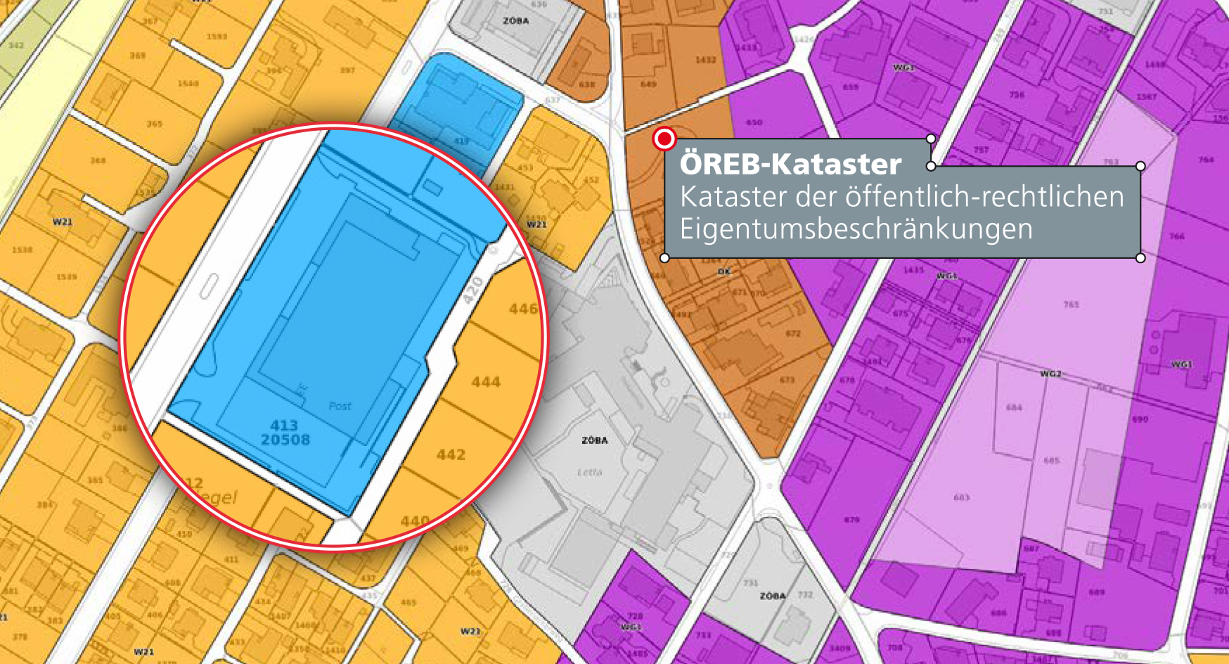
ÖREB-Kataster Fürstentum Liechtenstein
Die wichtigsten öffentlich-rechtlichen Eigentumsbeschränkungen auf einen Klick Grundlegende Informationen für alle, die ein Grundstück besitzen, ein Haus bauen möchten oder sich mit Immobilien beschäftigen.
Für die Nutzung von Grundstücken gibt es in Liechtenstein zahlreiche Gesetze, Verordnungen und behördliche Einschränkungen – die sogenannten öffentlich-rechtlichen Eigentumsbeschränkungen (ÖREB). Zonenpläne geben beispielsweise die erlaubte Bauhöhe in einer bestimmten Zone vor und Baulinienpläne legen den Mindestabstand zwischen Haus und Grundstücksgrenze fest.
Simple
- Date (Publication)
- 2021-07-01
- Identifier
- https://geodaten.llv.li/metadata/09d0ed3b-7bf4-4301-bb23-2027fd160ab5
- Purpose
-
Kataster der öffentlich-rechtlichen Eigentumsbeschränkungen
- Status
- On going
Point of contact
- Hours of service
-
8:00-11:30 und 13:30-17:00
- Topic category
-
- A Imagery base maps earth cover
- E Planning cadastre
- G Biota
- I Inland waters
- L Environment
Extent
Extent
- Description
-
Liechtenstein
))

- Maintenance and update frequency
- Continual
- GEMET - INSPIRE themes, version 1.0
-
-
Cadastral parcels
-
Habitats and biotopes
-
Land use
-
Protected sites
-
- GEMET themes
-
-
legislation
-
administration
-
natural areas, landscape, ecosystems
-
noise, vibrations
-
building
-
- Räumlicher Anwendungsbereich
-
-
National
-
- geocat.ch
-
-
groundwater protection area
-
quarter map
-
geoservice
-
cadastral surveying
-
nature
-
polluted site
-
protection zone
-
site
-
water protection sector
-
primary use
-
development plan
-
OeREB
-
- Theme
-
-
landscape
-
building area
-
groundwater protection
-
water (geographic)
-
natural areas protection
-
biotope
-
natural areas, landscape, ecosystems
-
noise, vibrations
-
legislation
-
built environment
-
building
-
building land
-
Resource constraints
- Use limitation
-
Andere Einschränkungen
- Country
- LI
- Legislation Type
- nationalLaw
- Title
-
Gesetz vom 2. März 2018 über den Kataster der öffentlich-rechtlichen Eigentumsbeschränkungen
- Date (Creation)
- 2018-07-01
- Language
- Deutsch
- Character encoding
- UTF8
- Subtopic Category
- A1 Base Maps, Landscape Models
- Subtopic Category
- E1 Spatial Planning, Spatial Development
- Subtopic Category
- E2 Cadastre, Land Registry
- Subtopic Category
- L1 Environmental Protection, Noise
- Subtopic Category
- L2 Nature and Landscape Protection
- Distribution format
-
-
Portable Network Graphics (PNG)
-
Digital transfer options
- OnLine resource
-
Kataster der öffentlich-rechtlichen Eigentumsbeschränkungen
Digital transfer options
- OnLine resource
-
DE#WMS OEREB-Kataster Fürstentum Liechtenstein
- Hierarchy level
- Dataset
- Other
-
alle Ebenen
Report
Result
- Title
-
VERORDNUNG (EG) Nr. 1089/2010 DER KOMMISSION vom 23. November 2010 zur Durchführung der Richtlinie 2007/2/EG des Europäischen Parlaments und des Rates hinsichtlich der Interoperabilität von Geodatensätzen und -diensten
- Date (Publication)
- 2010-12-08
- Explanation
-
nicht geprüft
- Pass
- false
- Statement
-
ÖREB-Rahmenmodelle
- Hierarchy level
- Dataset
- Other
-
alle Ebenen
- Topology level
- Full planar graph
- Topology level
- Topology 1D
- Reference system identifier
- http://www.opengis.net/def/crs/EPSG/0/2056
- Maintenance and update frequency
- Continual
Metadata
- Metadata identifier
- 09d0ed3b-7bf4-4301-bb23-2027fd160ab5
- Language
- Deutsch
- Character encoding
- UTF8
- Language
- Français
- Character encoding
- UTF8
- Language
- Italiano
- Character encoding
- UTF8
- Language
- English
- Character encoding
- UTF8
Point of contact
- Hours of service
-
8:00-11:30 und 13:30-17:00
Type of resource
- Resource scope
- Dataset
- Metadata linkage
-
https://www.geocat.ch/geonetwork/srv/api/records/09d0ed3b-7bf4-4301-bb23-2027fd160ab5
- Date info (Creation)
- 2021-07-01T05:37:15Z
- Date info (Revision)
- 2026-04-13T08:53:13.814271Z