 geocat.ch
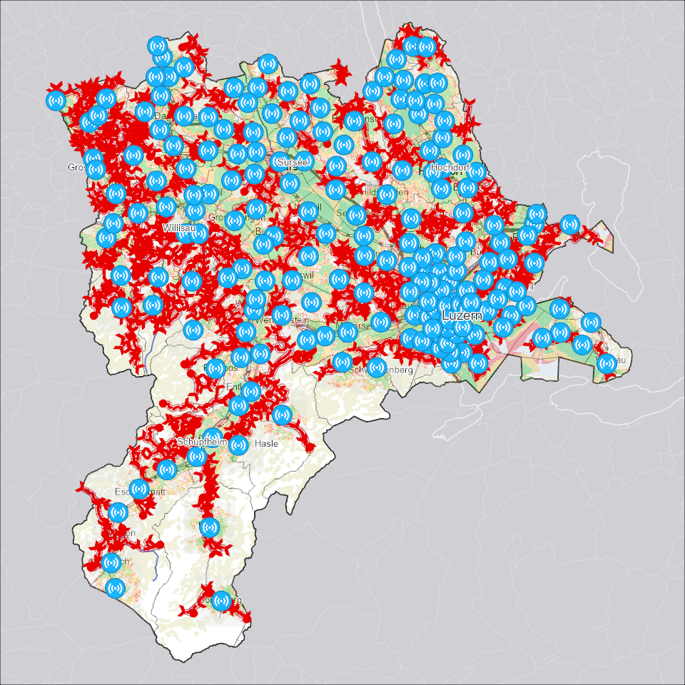
Sirenenstandorte mit Beschallung
Sirenenabdeckung innerhalb des Kanton Luzern mit Sirenenstandorten, mobiler Alarmierung und Schallteppich.
Simple
- Alternate title
-
SIREXXXX_COL
- Date (Creation)
- 2026-03-31
- Presentation form
- Digital map
- Purpose
-
Die Sirenenstandorte und der Schallteppich zeigen die stationäre Alarmierung der Luzerner Bevölkerung.Die Mobilen Sirenen zeigen mit den Startpunkten, Fahrtrichtungen und Endpunkten, wie abgelegenere Gebiete erreicht werden.Die möglichst flächendeckende Alarmierung ist wichtig, um die Bevölkerung in Gefahrensituationen erreichen zu können.!!! Hinweis für den Datenbezug: Für einen kompletten Bezug der Kollektion müssen sowohl Rasterdaten (tif) wie auch Vektordaten (fgdb, shp, gpk) bezogen werden.
- Status
- On going
Publisher
Owner
- Spatial representation type
- undefined
- Topic category
-
- R Intelligence military
Extent
Extent
- Description
-
Kanton Luzern
))
- Maintenance and update frequency
- As needed
- geocat.ch
-
-
opendata.swiss
-
Bevölkerung
-
Sicherheit
-
Zivilschutz
-
Resource constraints
- Access constraints
- none
- Use constraints
- Copyright
Resource constraints
- Use limitation
-
öffentlich zugängliche Geobasisdaten
Resource constraints
- Access constraints
- none
- Use constraints
- none
Resource constraints
- Use limitation
-
Freie Nutzung. Quellenangabe ist Pflicht
Associated resource
- Association Type
- Reference to a master resource of which this one is a part
- Metadata Reference
Associated resource
- Association Type
- Reference to a master resource of which this one is a part
- Metadata Reference
Associated resource
- Association Type
- Reference to a master resource of which this one is a part
- Metadata Reference
Associated resource
- Association Type
- Reference to a master resource of which this one is a part
- Metadata Reference
- Distribution format
-
-
Tagged Image File Format (.tif)
-
ESRI Geodatabase (.gdb)
-
ESRI Shapefile (.shp)
-
OGC GeoPackage (.gpkg)
-
Point of contact
Digital transfer options
- OnLine resource
-
Datenshop
Produktansicht Geodatenshop
- Statement
-
unbekannt
- Reference system identifier
- EPSG:2056
- Maintenance and update frequency
- As needed
Metadata
- Metadata identifier
- 09aeb6d1-8833-43c7-9fa0-71af63297775
- Language
- Deutsch
- Character encoding
- UTF-8
Point of contact
Type of resource
- Resource scope
- Dataset
- Metadata linkage
-
https://www.geocat.ch/geonetwork/srv/api/records/09aeb6d1-8833-43c7-9fa0-71af63297775
- Date info (Creation)
- 2024-02-20
- Date info (Revision)
- 2026-06-20T03:34:37.932264Z
Metadata standard
- Title
-
ISO19115.3-2018.che
)))