geocat.ch
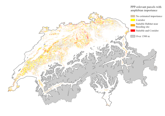
Agricultural parcels with potential importance to amphibians, surfaces
Switzerland-wide map of agricultural parcels that are potentially suitable as either terrestrial habitat or as part of a dispersal route between amphibian breeding sites for up to 11 amphibian species. For each agricultural parcel, the dataset contains in its attributes information on which species (if any) are found in an amphibian breeding site near the parcel (within 200 m, 500 m or 1 km) and are likely to use the parcel as terrestrial habitat. Likewise, it is indicated which species (if any) are highly likely to have dispersal routes between breeding sites that pass through the plot.
In the default view of the map, all parcels are shown that are suitable as terrestrial habitat for at least one species with a nearby spawning site (within 500 m) and/or along a dispersal route of at least one species. By selecting a parcel, you can see which species could potentially use that parcel using the columns “species_suitXXX” and “species_corridors" (Alias: "Terrestrial habitat XXXm" and "Dispersal"), which contain a list of the Latin names of each species. 'species_suit200' is suitable habitat for a species with a breeding site within 200 m, 'species_suit500' for 500 m and 'species_suit1000' for 1000 m.
The map is based on the spatial combination of the Swiss Agricultural Parcel Map of 2021 (KGK-CGC. (2022). Agricultural Landuse 2021. https://geodienste.ch/) and suitability and dispersal maps for 11 amphibian species. The map differentiates between the basic agricultural parcels and overlapping elements such as biodiversity promotion areas and small structures. Only the data set with the basic parcels is available in the Federal Geodata Infrastructure.
Further details can be found in the attached data description.
Literature:
Churko G., Szerencsits E., Aldrich A., Schmidt B. R. (2024). Spatial analysis of the potential exposure of amphibians to plant protection products at the landscape scale. Basic and Applied Ecology, 76, 14-24. https://doi.org/10.1016/j.baae.2024.02.004
Simple
- Alternate title
-
Agriculture and amphibians
- Date (Publication)
- 2024-02
- Date (Creation)
- 2021
- Identifier
- ch.agroscope.Landw_Parzelle_Bedeutung_Amphibien
- Status
- Completed
Author
Principal investigator
Point of contact
- Spatial representation type
- Vector
- Topic category
-
- G Biota
- L Environment
- S Farming
Extent
Extent
- Description
-
Switzerland
))

- Maintenance and update frequency
- Not planned
Resource format
- Title
-
ESRI File Geodatabase FileGDB (GDB)
- Date
- GEMET themes
-
-
natural areas, landscape, ecosystems
-
agriculture
-
- GEMET
-
-
nature conservation
-
fauna
-
agriculture
-
amphibian
-
- geocat.ch
-
-
confederation
-
opendata.swiss
-
FSDI Federal Spatial Data Infrastructure
-
Resource constraints
Associated resource
- Association Type
- Reference to a master resource of which this one is a part
- Metadata Reference
Associated resource
- Association Type
- Reference to a master resource of which this one is a part
- Metadata Reference
Associated resource
- Association Type
- Reference to a master resource of which this one is a part
- Metadata Reference
Associated resource
- Association Type
- Reference to a master resource of which this one is a part
- Metadata Reference
Associated resource
- Association Type
- Reference to a master resource of which this one is a part
- Metadata Reference
Associated resource
- Association Type
- Reference to a master resource of which this one is a part
- Metadata Reference
Associated resource
- Association Type
- Reference to a master resource of which this one is a part
- Metadata Reference
Associated resource
- Association Type
- Reference to a master resource of which this one is a part
- Metadata Reference
Associated resource
- Association Type
- Reference to a master resource of which this one is a part
- Metadata Reference
Associated resource
- Association Type
- Reference to a master resource of which this one is a part
- Metadata Reference
Associated resource
- Association Type
- Reference to a master resource of which this one is a part
- Metadata Reference
Associated resource
- Association Type
- Reference to a master resource of which this one is a part
- Metadata Reference
Associated resource
- Association Type
- Reference to a master resource of which this one is a part
- Metadata Reference
Associated resource
- Association Type
- Reference to a master resource of which this one is a part
- Metadata Reference
Associated resource
- Association Type
- Reference to a master resource of which this one is a part
- Metadata Reference
Associated resource
- Title
-
-- Bezeichnung gemäss: «Bezeichnung GeoIV» (in GeoIV Anhang 1, Spalte B) --
- Association Type
- Reference to a master resource of which this one is a part
- Language
- Deutsch
- Character encoding
- UTF8
- Subtopic Category
- L2 Nature and Landscape Protection
- Basic Geodata
- false
- Basic Geodata Legal Level
- Federal
- Basic Geodata Type
- openData
- Distribution format
-
-
ESRI File Geodatabase FileGDB (GDB)
-
Owner
Distributor
Digital transfer options
- OnLine resource
-
Datenbeschreibung_AmphibienAckerland.pdf
Digital transfer options
- OnLine resource
-
STAC Browser
Link zum Datenbezung
Digital transfer options
- OnLine resource
-
DescriptionDonnees_BatrachiensAgricole.pdf
Download der Datenbeschreibung
Digital transfer options
- OnLine resource
-
Vorschau bei map.geo.admin.ch
Vorschau bei map.geo.admin.ch
Digital transfer options
- OnLine resource
-
ch.agroscope.ndw_Parzelle_Bedeutung_Amphibien
WMS-BGDI service Layer "Agriculture and amphibianss"
Digital transfer options
- OnLine resource
-
ch.agroscope.ndw_Parzelle_Bedeutung_Amphibien
WMTS-BGDI service Layer "Agriculture and amphibians"
Digital transfer options
- OnLine resource
-
ch.agroscope.amphibien-bedeutung_parzellen
WMS-FSDI service, layer "Agriculture and amphibians"
Digital transfer options
- OnLine resource
-
ch.agroscope.amphibien-bedeutung_parzellen
WMTS-FSDI service, layer "Parcels important amphibians"
Digital transfer options
- OnLine resource
-
RESTful API von geo.admin.ch
Digital transfer options
- OnLine resource
-
Vorschau map.geo.admin.ch
- Geometric object type
- Surface
- Reference system identifier
- LV95 EPSG:2056
- Maintenance and update frequency
- As needed
Metadata
- Metadata identifier
- 0916243e-68d9-41c5-95f7-0f657e2ee07f
- Language
- Deutsch
- Character encoding
- UTF8
- Language
- Français
- Character encoding
- UTF8
- Language
- Italiano
- Character encoding
- UTF8
- Language
- English
- Character encoding
- UTF8
- Language
- Rumantsch
- Character encoding
- UTF8
Owner
Type of resource
- Resource scope
- Dataset
- Metadata linkage
-
https://www.geocat.ch/geonetwork/srv/api/records/0916243e-68d9-41c5-95f7-0f657e2ee07f
- Date info (Creation)
- 2024-04-29T07:19:47.663Z
- Date info (Revision)
- 2026-06-15T07:30:08.680011Z
Metadata standard
- Title
-
eCH-0271