geocat.ch
Landwirtschaftliche Parzellen mit potenzieller Bedeutung für Amphibien, Flächen
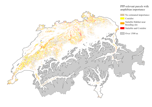
Schweizweite Karte mit landwirtschaftlichen Parzellen, die sich potenziell entweder als terrestrischer Lebensraum oder als Teil einer Ausbreitungsroute zwischen Amphibeinlaichgebieten für eine bis 11 Amphibienarten eignen. Für jede landwirtschaftliche Parzelle enthält der Datensatz in seinen Attributen Informationen, welche Arten (falls vorhanden) in einem Amphibienlaichgebiet in der Nähe der Parzelle (innerhalb von 200 m, 500 m oder 1 km) zu finden sind und die Parzelle wahrscheinlich als terrestrischen Lebensraum nutzen werden. Ebenso wird angegeben, welche Arten (falls vorhanden) mit hoher Wahrscheinlichkeit Ausbreitungsrouten zwischen den Laichgewässern haben, die durch die Parzelle verlaufen.
In der Standardansicht der Karte werden alle Parzellen angezeigt, die als Landlebensraum für mindestens eine Art mit einem nahe gelegenen Laichort (innerhalb von 500 m) geeignet sind und/oder entlang einer Ausbreitungsroute mindestens einer Art liegen. Durch Auswahl einer Parzelle können Sie anhand der Spalten „species_suitXXX“ und „species_corridors“ (Alias: "Landlebensraum XXXm" und "Ausbreitung"), die eine Liste der lateinischen Namen jeder Art enthalten, sehen, welche Arten diese Parzelle nutzen. „species_suit200“ ist ein geeigneter Lebensraum für eine Art mit einem Laichort innerhalb von 200 m, ‚species_suit500‘ für 500 m und ‚species_suit1000‘ für 1000 m.
Die Karte basiert auf der räumlichen Verknüpfung der Schweizer Landwirtschaftsparzellenkarte von 2021 (KGK-CGC. (2022). Agricultural Landuse 2021. https://geodienste.ch/) und den Eignungs- und Ausbreitungskarten für jede der 11 Amphibienarten. Die Landwirtschaftsparzellenkarte unterscheidet den landwirtschaftliche Grundparzellen und überlagernde Elemente wie Biodiversitätsförderflächen und Kleinstrukturen. In der BGDI ist nur der Datensatz mit den Grundparzellen erhältlich.
Weitere Details in der beigefügten Datenbeschreibung.
LIteratur:
Churko G., Szerencsits E., Aldrich A., Schmidt B. R. (2024). Spatial analysis of the potential exposure of amphibians to plant protection products at the landscape scale. Basic and Applied Ecology, 76, 14-24. https://doi.org/10.1016/j.baae.2024.02.004
Semplice
- Altri nomi o acronimi
-
Landwirtschaft und Amphibien
- Data (Pubblicazione)
- 2024-02
- Data (Creazione)
- 2021
- Identificatore
- ch.agroscope.Landw_Parzelle_Bedeutung_Amphibien
- Stato
- Completato
Autore
Ricercatore principale
Punto di contatto
- Tipo di rappresentazione spaziale
- Vettoriale
- Categoria ISO
-
- G Biota
- L Ambiente
- S Agricoltura
Estensione
Estensione
- Descrizione
-
Svizzera
))

- Frequenza di aggiornamento
- Non pianificato
Formato della risorsa
- Titolo
-
ESRI File Geodatabase FileGDB (GDB)
- Data
- GEMET themes
-
-
aree naturali, paesaggio, ecosistemi
-
agricoltura
-
- GEMET
-
-
conservazione della natura
-
fauna
-
agricoltura
-
anfibi
-
- geocat.ch
-
-
confederazione
-
opendata.swiss
-
IFDG Infrastruttura federale dei dati geografici
-
Vincoli sulle risorse
Risorsa associata
- Tipo di associazione
- Citazione di un'opera più ampia
- Riferimento metadati
Risorsa associata
- Tipo di associazione
- Citazione di un'opera più ampia
- Riferimento metadati
Risorsa associata
- Tipo di associazione
- Citazione di un'opera più ampia
- Riferimento metadati
Risorsa associata
- Tipo di associazione
- Citazione di un'opera più ampia
- Riferimento metadati
Risorsa associata
- Tipo di associazione
- Citazione di un'opera più ampia
- Riferimento metadati
Risorsa associata
- Tipo di associazione
- Citazione di un'opera più ampia
- Riferimento metadati
Risorsa associata
- Tipo di associazione
- Citazione di un'opera più ampia
- Riferimento metadati
Risorsa associata
- Tipo di associazione
- Citazione di un'opera più ampia
- Riferimento metadati
Risorsa associata
- Tipo di associazione
- Citazione di un'opera più ampia
- Riferimento metadati
Risorsa associata
- Tipo di associazione
- Citazione di un'opera più ampia
- Riferimento metadati
Risorsa associata
- Tipo di associazione
- Citazione di un'opera più ampia
- Riferimento metadati
Risorsa associata
- Tipo di associazione
- Citazione di un'opera più ampia
- Riferimento metadati
Risorsa associata
- Tipo di associazione
- Citazione di un'opera più ampia
- Riferimento metadati
Risorsa associata
- Tipo di associazione
- Citazione di un'opera più ampia
- Riferimento metadati
Risorsa associata
- Tipo di associazione
- Citazione di un'opera più ampia
- Riferimento metadati
Risorsa associata
- Titolo
-
-- Denominazione in conformità a: "Raccolta dei geodati di base di diritto federale" --
- Tipo di associazione
- Citazione di un'opera più ampia
- Lingua
- Deutsch
- Codifica dei caratteri
- UTF8
- Categoria di sottotema
- L2 Protezione della natura e del paesaggio
- Geodati di base
- false
- Livello legale dei geodati di base
- Federale
- Tipo di geodati di base
- openData
- Formato (codifica)
-
-
ESRI File Geodatabase FileGDB (GDB)
-
Proprietario
Distributore
Opzioni di trasferimento digitale
- Risorsa online
-
Datenbeschreibung_AmphibienAckerland.pdf
Opzioni di trasferimento digitale
- Risorsa online
-
STAC Browser
Link zum Datenbezung
Opzioni di trasferimento digitale
- Risorsa online
-
DescriptionDonnees_BatrachiensAgricole.pdf
Download der Datenbeschreibung
Opzioni di trasferimento digitale
- Risorsa online
-
Vorschau bei map.geo.admin.ch
Vorschau bei map.geo.admin.ch
Opzioni di trasferimento digitale
- Risorsa online
-
ch.agroscope.ndw_Parzelle_Bedeutung_Amphibien
WMS-BGDI Dienst, Layer "Bedeutung landw. Parzellen Amphibien"
Opzioni di trasferimento digitale
- Risorsa online
-
ch.agroscope.ndw_Parzelle_Bedeutung_Amphibien
WMTS-BGDI Dienst, Layer "Bedeutung landw. Parzellen Amphibien"
Opzioni di trasferimento digitale
- Risorsa online
-
ch.agroscope.amphibien-bedeutung_parzellen
Servizio WMS-IFDG, strato "Agriculture et amphibiens"
Opzioni di trasferimento digitale
- Risorsa online
-
ch.agroscope.amphibien-bedeutung_parzellen
Servizio WMTS-IFDG, strato "-"
Opzioni di trasferimento digitale
- Risorsa online
-
RESTful API von geo.admin.ch
Opzioni di trasferimento digitale
- Risorsa online
-
Vorschau map.geo.admin.ch
- Tipo di oggetto geometrico
- Superficie
- Nome del sistema di riferimento
- LV95 EPSG:2056
- Frequenza di aggiornamento
- Secondo necessità
Metadati
- Identificativo della scheda
- 0916243e-68d9-41c5-95f7-0f657e2ee07f
- Lingua
- Deutsch
- Codifica dei caratteri
- UTF8
- Lingua
- Français
- Codifica dei caratteri
- UTF8
- Lingua
- Italiano
- Codifica dei caratteri
- UTF8
- Lingua
- English
- Codifica dei caratteri
- UTF8
- Lingua
- Rumantsch
- Codifica dei caratteri
- UTF8
Proprietario
Tipo di risorsa
- Ambito di applicazione della risorsa
- Set di dati
- Collegamento ai metadati
-
https://www.geocat.ch/geonetwork/srv/api/records/0916243e-68d9-41c5-95f7-0f657e2ee07f
- Informazioni sulla data (Creazione)
- 2024-04-29T07:19:47.663Z
- Informazioni sulla data (Revisione)
- 2026-06-15T07:30:08.680011Z
Standard dei metadati
- Titolo
-
eCH-0271