geocat.ch
Landwirtschaftliche Parzellen mit potenzieller Bedeutung für Amphibien, Flächen
Parcelles agricoles potentiellement importantes pour les amphibiens, surfaces
Agricultural parcels with potential importance to amphibians, surfaces
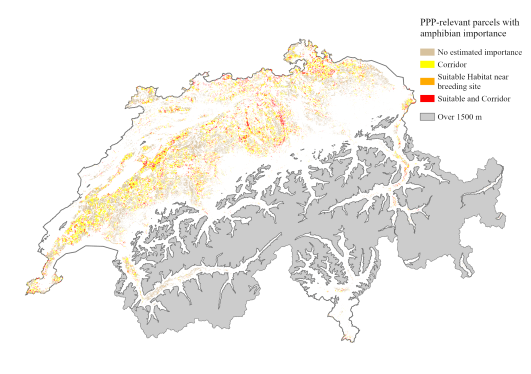
Schweizweite Karte mit landwirtschaftlichen Parzellen, die sich potenziell entweder als terrestrischer Lebensraum oder als Teil einer Ausbreitungsroute zwischen Amphibeinlaichgebieten für eine bis 11 Amphibienarten eignen. Für jede landwirtschaftliche Parzelle enthält der Datensatz in seinen Attributen Informationen, welche Arten (falls vorhanden) in einem Amphibienlaichgebiet in der Nähe der Parzelle (innerhalb von 200 m, 500 m oder 1 km) zu finden sind und die Parzelle wahrscheinlich als terrestrischen Lebensraum nutzen werden. Ebenso wird angegeben, welche Arten (falls vorhanden) mit hoher Wahrscheinlichkeit Ausbreitungsrouten zwischen den Laichgewässern haben, die durch die Parzelle verlaufen.
In der Standardansicht der Karte werden alle Parzellen angezeigt, die als Landlebensraum für mindestens eine Art mit einem nahe gelegenen Laichort (innerhalb von 500 m) geeignet sind und/oder entlang einer Ausbreitungsroute mindestens einer Art liegen. Durch Auswahl einer Parzelle können Sie anhand der Spalten „species_suitXXX“ und „species_corridors“ (Alias: "Landlebensraum XXXm" und "Ausbreitung"), die eine Liste der lateinischen Namen jeder Art enthalten, sehen, welche Arten diese Parzelle nutzen. „species_suit200“ ist ein geeigneter Lebensraum für eine Art mit einem Laichort innerhalb von 200 m, ‚species_suit500‘ für 500 m und ‚species_suit1000‘ für 1000 m.
Die Karte basiert auf der räumlichen Verknüpfung der Schweizer Landwirtschaftsparzellenkarte von 2021 (KGK-CGC. (2022). Agricultural Landuse 2021. https://geodienste.ch/) und den Eignungs- und Ausbreitungskarten für jede der 11 Amphibienarten. Die Landwirtschaftsparzellenkarte unterscheidet den landwirtschaftliche Grundparzellen und überlagernde Elemente wie Biodiversitätsförderflächen und Kleinstrukturen. In der BGDI ist nur der Datensatz mit den Grundparzellen erhältlich.
Weitere Details in der beigefügten Datenbeschreibung.
LIteratur:
Churko G., Szerencsits E., Aldrich A., Schmidt B. R. (2024). Spatial analysis of the potential exposure of amphibians to plant protection products at the landscape scale. Basic and Applied Ecology, 76, 14-24. https://doi.org/10.1016/j.baae.2024.02.004
Carte à l'échelle nationale des parcelles agricoles potentiellement adaptées, soit comme habitat terrestre, soit comme partie d'une voie de dispersion entre des sites de reproduction d'amphibiens pour une à 11 espèces d'amphibiens. Pour chaque parcelle agricole, l'ensemble de données contient des informations sur les espèces (le cas échéant) présentes dans un site de reproduction d'amphibiens à proximité de la parcelle (dans un rayon de 200 m, 500 m ou 1 km) et susceptibles d'utiliser la parcelle comme habitat terrestre. De même, il est indiqué quelles espèces ont une forte probabilité d'avoir des voies de dispersion entre les zones de reproduction qui traversent la parcelle.
La vue standard de la carte affiche toutes les parcelles qui sont appropriées comme habitat terrestre pour au moins une espèce ayant un site de reproduction à proximité (dans un rayon de 500 m) et/ou qui se trouvent le long d'une voie de dispersion d'au moins une espèce. En sélectionnant une parcelle, vous pouvez voir quelles espèces utilisent cette parcelle grâce aux colonnes "species_suitXXX" et "species_corridors" (Alias: "Habitat terrestre XXXm" et "Diffusion"), qui contiennent une liste des noms latins de chaque espèce. "species_suit200" est un habitat approprié pour une espèce dont le site de reproduction se situe à moins de 200 m, "species_suit500" pour 500 m et "species_suit1000" pour 1000 m.
La carte est basée sur le lien spatial de la Carte des parcelles agricoles suisses de 2021 (KGK-CGC. (2022). Agricultural Landuse 2021. https://geodienste.ch/) et les cartes d'aptitude et de répartition de chacune des 11 espèces d'amphibiens. La carte des parcelles agriocoles suisse distingue les parcelles agricoles de base et les élément superposés tels que les surfaces de promotion de la biodiversité (SPB) et les petites structures. Dans l'infrastructure des géodonnées, seul l'ensemble de données contenant les parcelles agricoles de base est disponible.
Pour plus de détails, voir la description des données ci-jointe.
Literature:
Churko G., Szerencsits E., Aldrich A., Schmidt B. R. (2024). Spatial analysis of the potential exposure of amphibians to plant protection products at the landscape scale. Basic and Applied Ecology, 76, 14-24. https://doi.org/10.1016/j.baae.2024.02.004
Switzerland-wide map of agricultural parcels that are potentially suitable as either terrestrial habitat or as part of a dispersal route between amphibian breeding sites for up to 11 amphibian species. For each agricultural parcel, the dataset contains in its attributes information on which species (if any) are found in an amphibian breeding site near the parcel (within 200 m, 500 m or 1 km) and are likely to use the parcel as terrestrial habitat. Likewise, it is indicated which species (if any) are highly likely to have dispersal routes between breeding sites that pass through the plot.
In the default view of the map, all parcels are shown that are suitable as terrestrial habitat for at least one species with a nearby spawning site (within 500 m) and/or along a dispersal route of at least one species. By selecting a parcel, you can see which species could potentially use that parcel using the columns “species_suitXXX” and “species_corridors" (Alias: "Terrestrial habitat XXXm" and "Dispersal"), which contain a list of the Latin names of each species. 'species_suit200' is suitable habitat for a species with a breeding site within 200 m, 'species_suit500' for 500 m and 'species_suit1000' for 1000 m.
The map is based on the spatial combination of the Swiss Agricultural Parcel Map of 2021 (KGK-CGC. (2022). Agricultural Landuse 2021. https://geodienste.ch/) and suitability and dispersal maps for 11 amphibian species. The map differentiates between the basic agricultural parcels and overlapping elements such as biodiversity promotion areas and small structures. Only the data set with the basic parcels is available in the Federal Geodata Infrastructure.
Further details can be found in the attached data description.
Literature:
Churko G., Szerencsits E., Aldrich A., Schmidt B. R. (2024). Spatial analysis of the potential exposure of amphibians to plant protection products at the landscape scale. Basic and Applied Ecology, 76, 14-24. https://doi.org/10.1016/j.baae.2024.02.004
Simple
-
Autre titreAltri nomi o acronimiAlternate titleAlternate titleAlternativtitel
-
Landwirtschaft und Amphibien
Agriculture et amphibiens
Agriculture and amphibians
-
Date (Publication)Data (Pubblicazione)Date (Publication)Date (Publication)Datum (Publikation)
- 2024-02
-
Date (Création)Data (Creazione)Date (Creation)Date (Creation)Datum (Erstellung)
- 2021
-
IdentifiantIdentificatoreIdentifierIdentifierKennung
- ch.agroscope.Landw_Parzelle_Bedeutung_Amphibien
-
ÉtatStatoStatusStatusBearbeitungsstatus
-
TerminéCompletatoCompletedCompletedAbgeschlossen
Auteur
Autore
Author
Author
Autor
Auteur principal de la recherche
Ricercatore principale
Principal investigator
Principal investigator
Projektleiter
Point de contact
Punto di contatto
Point of contact
Point of contact
Ansprechpartner
-
Type de représentation spatialeTipo di rappresentazione spazialeSpatial representation typeSpatial representation typeRäumliche Darstellungsart
-
vecteurVettorialeVectorVectorVektor
-
Catégorie de thèmeCategoria ISOTopic categoryTopic categoryThematik
-
-
G BioteG BiotaG BiotaG BiotaG Biologie
-
L EnvironnementL AmbienteL EnvironmentL EnvironmentL Umwelt
-
S ÉlevageS AgricolturaS FarmingS FarmingS Landwirtschaft
-
Étendue
Estensione
Extent
Extent
Ausdehnung
Étendue
Estensione
Extent
Extent
Ausdehnung
-
DescriptionDescrizioneDescriptionDescriptionBeschreibung
-
Switzerland
Schweiz
Suisse
Svizzera
Svizra
))

-
Fréquence de mise à jourFrequenza di aggiornamentoMaintenance and update frequencyMaintenance and update frequencyWartungsintervall
-
Non planifiéeNon pianificatoNot plannedNot plannedNicht geplant
Format de la ressource
Formato della risorsa
Resource format
Resource format
Format der Ressource
-
TitreTitoloTitleTitleTitel
-
ESRI File Geodatabase FileGDB (GDB)
-
DateDataDateDateDatum
- GEMET themes
-
-
zones naturelles, paysages, écosystèmes
aree naturali, paesaggio, ecosistemi
natural areas, landscape, ecosystems
-
agriculture
agricoltura
agriculture
-
- GEMET
-
-
préservation de la nature
conservazione della natura
nature conservation
-
faune
fauna
fauna
-
agriculture
agricoltura
agriculture
-
batracien
anfibi
amphibian
-
- geocat.ch
-
-
confédération
confederazione
confederation
-
opendata.swiss
opendata.swiss
opendata.swiss
opendata.swiss
-
IFDG l’Infrastructure Fédérale de données géographiques
IFDG Infrastruttura federale dei dati geografici
FSDI Federal Spatial Data Infrastructure
-
Contraintes sur la ressource
Vincoli sulle risorse
Resource constraints
Resource constraints
Ressourcenbeschränkungen
-
Contraintes d'accèsVincoli di accessoAccess constraintsAccess constraintsZugriffsbeschränkungen
-
Droit d’auteurCopyrightCopyrightCopyrightUrheberrecht
-
Contraintes d'utilisationVincoli d'usoUse constraintsUse constraintsNutzungseinschränkungen
-
Droit d’auteurCopyrightCopyrightCopyrightUrheberrecht
-
Autres contraintesAltri vincoliOther constraintsOther constraintsAndere Einschränkungen
- Opendata OPEN: Freie Nutzung.Opendata OPEN: Utilisation libre.Opendata OPEN: Libero utilizzo.Opendata OPEN: Open use.
Ressource associée
Risorsa associata
Associated resource
Associated resource
Verlinkte Ressource
-
Type d'associationTipo di associazioneAssociation TypeAssociation TypeAssoziationstyp
-
Citation de travail plus largeCitazione di un'opera più ampiaReference to a master resource of which this one is a partReference to a master resource of which this one is a partÜbergeordneter Datenbestand
-
Metadata ReferenceRiferimento metadatiMetadata ReferenceMetadata ReferenceMetadatenreferenz
Ressource associée
Risorsa associata
Associated resource
Associated resource
Verlinkte Ressource
-
TitreTitoloTitleTitleTitel
-
-- Bezeichnung gemäss: «Bezeichnung GeoIV» (in GeoIV Anhang 1, Spalte B) --
-- Appellation selon: "Désignation OGéo" (dans OGéo, annexe 1, colonne B) --
-- Denominazione in conformità a: "Raccolta dei geodati di base di diritto federale" --
-
Type d'associationTipo di associazioneAssociation TypeAssociation TypeAssoziationstyp
-
Citation de travail plus largeCitazione di un'opera più ampiaReference to a master resource of which this one is a partReference to a master resource of which this one is a partÜbergeordneter Datenbestand
-
LangueLinguaLanguageLanguageSprache
- Deutsch
-
Encodage de caractèresCodifica dei caratteriCharacter encodingCharacter encodingZeichenkodierung
-
Utf8UTF8UTF8UTF8Utf8
-
Catégorie de sous-thèmeCategoria di sottotemaSubtopic CategorySubtopic CategoryThematische Unterkategorien
-
L2 Protection de la nature et du paysageL2 Protezione della natura e del paesaggioL2 Nature and Landscape ProtectionL2 Nature and Landscape ProtectionL2 Natur- und Landschaftsschutz
-
Géodonnées de baseGeodati di baseBasic GeodataBasic GeodataGeobasisdaten
- false
-
Niveau des géodonnées de baseLivello legale dei geodati di baseBasic Geodata Legal LevelBasic Geodata Legal LevelGeobasisdatenebene
-
FédéralFederaleFederalFederalNational
-
Type de géodonnées de baseTipo di geodati di baseBasic Geodata TypeBasic Geodata TypeGeobasisdatentyp
-
openDataopenDataopenDataopenDataopenData
-
Format de distributionFormato (codifica)Distribution formatDistribution formatAbgabeformat
-
-
ESRI File Geodatabase FileGDB (GDB)
-
Propriétaire
Proprietario
Owner
Owner
Eigentümer
Distributeur
Distributore
Distributor
Distributor
Verteiler
Options de transfert numérique
Opzioni di trasferimento digitale
Digital transfer options
Digital transfer options
Optionen für die digitale Übertragung
-
Ressource en ligneRisorsa onlineOnLine resourceOnLine resourceOnline
-
Datenbeschreibung_AmphibienAckerland.pdf
Options de transfert numérique
Opzioni di trasferimento digitale
Digital transfer options
Digital transfer options
Optionen für die digitale Übertragung
-
Ressource en ligneRisorsa onlineOnLine resourceOnLine resourceOnline
-
STAC Browser
Link zum Datenbezung
Options de transfert numérique
Opzioni di trasferimento digitale
Digital transfer options
Digital transfer options
Optionen für die digitale Übertragung
-
Ressource en ligneRisorsa onlineOnLine resourceOnLine resourceOnline
-
DescriptionDonnees_BatrachiensAgricole.pdf
Download der Datenbeschreibung
Options de transfert numérique
Opzioni di trasferimento digitale
Digital transfer options
Digital transfer options
Optionen für die digitale Übertragung
-
Ressource en ligneRisorsa onlineOnLine resourceOnLine resourceOnline
-
Vorschau bei map.geo.admin.ch
Vorschau bei map.geo.admin.ch
Options de transfert numérique
Opzioni di trasferimento digitale
Digital transfer options
Digital transfer options
Optionen für die digitale Übertragung
-
Ressource en ligneRisorsa onlineOnLine resourceOnLine resourceOnline
-
ch.agroscope.ndw_Parzelle_Bedeutung_Amphibien
WMS-BGDI Dienst, Layer "Bedeutung landw. Parzellen Amphibien"WMS-BGDI service Layer "Agriculture et amphibiens"WMS-BGDI service Layer "Agriculture and amphibianss"
Options de transfert numérique
Opzioni di trasferimento digitale
Digital transfer options
Digital transfer options
Optionen für die digitale Übertragung
-
Ressource en ligneRisorsa onlineOnLine resourceOnLine resourceOnline
-
ch.agroscope.ndw_Parzelle_Bedeutung_Amphibien
WMTS-BGDI Dienst, Layer "Bedeutung landw. Parzellen Amphibien"WMTS-BGDI service Layer "Agriculture et amphibiens"WMTS-BGDI service Layer "Agriculture and amphibians"
Options de transfert numérique
Opzioni di trasferimento digitale
Digital transfer options
Digital transfer options
Optionen für die digitale Übertragung
-
Ressource en ligneRisorsa onlineOnLine resourceOnLine resourceOnline
-
ch.agroscope.amphibien-bedeutung_parzellen
WMS-BGDI Dienst, Layer "Landwirtschaft und Amphibien"Service WMS-IFDG, couche "Agriculture et amphibiens"Servizio WMS-IFDG, strato "Agriculture et amphibiens"WMS-FSDI service, layer "Agriculture and amphibians"WMS-BGDI Dienst, Layer "Bedeutung Parzellen Amphibien"
Options de transfert numérique
Opzioni di trasferimento digitale
Digital transfer options
Digital transfer options
Optionen für die digitale Übertragung
-
Ressource en ligneRisorsa onlineOnLine resourceOnLine resourceOnline
-
ch.agroscope.amphibien-bedeutung_parzellen
WMTS-BGDI Dienst, Layer "Landwirtschaft und Amphibien"Service WMTS-IFDG, couche "Parcelles importantes amphibiens"Servizio WMTS-IFDG, strato "-"WMTS-FSDI service, layer "Parcels important amphibians"WMTS-BGDI Dienst, Layer "Bedeutung Parzellen Amphibien"
Options de transfert numérique
Opzioni di trasferimento digitale
Digital transfer options
Digital transfer options
Optionen für die digitale Übertragung
-
Ressource en ligneRisorsa onlineOnLine resourceOnLine resourceOnline
-
RESTful API von geo.admin.ch
Options de transfert numérique
Opzioni di trasferimento digitale
Digital transfer options
Digital transfer options
Optionen für die digitale Übertragung
-
Ressource en ligneRisorsa onlineOnLine resourceOnLine resourceOnline
-
Vorschau map.geo.admin.ch
-
Type d’objet géométriqueTipo di oggetto geometricoGeometric object typeGeometric object typeTyp des geometrischen Objekts
-
PolygoneSuperficieSurfaceSurfacesurface
-
Nom du système de référenceNome del sistema di riferimentoReference system identifierReference system identifierName des Referenzsystems
- LV95 EPSG:2056
-
Fréquence de mise à jourFrequenza di aggiornamentoMaintenance and update frequencyMaintenance and update frequencyWartungsintervall
-
Comme nécessaireSecondo necessitàAs neededAs neededBei Bedarf
Metadata
-
Identifiant des métadonnéesIdentificativo della schedaMetadata identifierMetadata identifierIdentifikator des Metadatensatzes
- 0916243e-68d9-41c5-95f7-0f657e2ee07f
-
LangueLinguaLanguageLanguageSprache
- Deutsch
-
Encodage de caractèresCodifica dei caratteriCharacter encodingCharacter encodingZeichenkodierung
-
Utf8UTF8UTF8UTF8Utf8
-
LangueLinguaLanguageLanguageSprache
- Français
-
Encodage de caractèresCodifica dei caratteriCharacter encodingCharacter encodingZeichenkodierung
-
Utf8UTF8UTF8UTF8Utf8
-
LangueLinguaLanguageLanguageSprache
- Italiano
-
Encodage de caractèresCodifica dei caratteriCharacter encodingCharacter encodingZeichenkodierung
-
Utf8UTF8UTF8UTF8Utf8
-
LangueLinguaLanguageLanguageSprache
- English
-
Encodage de caractèresCodifica dei caratteriCharacter encodingCharacter encodingZeichenkodierung
-
Utf8UTF8UTF8UTF8Utf8
-
LangueLinguaLanguageLanguageSprache
- Rumantsch
-
Encodage de caractèresCodifica dei caratteriCharacter encodingCharacter encodingZeichenkodierung
-
Utf8UTF8UTF8UTF8Utf8
Propriétaire
Proprietario
Owner
Owner
Eigentümer
Type de ressource
Tipo di risorsa
Type of resource
Type of resource
Anwendungsbereich der Metadaten
-
Domaine d'application de la ressourceAmbito di applicazione della risorsaResource scopeResource scopeDomäne der Ressourcenanwendung
-
Jeu de donnéesSet di datiDatasetDatasetDatenbestand
-
Lien vers la métadonnéeCollegamento ai metadatiMetadata linkageMetadata linkageLink zu den Metadaten
-
Informations de date (Création)Informazioni sulla data (Creazione)Date info (Creation)Date info (Creation)Datumsangaben (Erstellung)
- 2024-04-29T07:19:47.663Z
-
Informations de date (Révision)Informazioni sulla data (Revisione)Date info (Revision)Date info (Revision)Datumsangaben (Aktualisierung)
- 2026-06-15T07:30:08.680011Z
Norme des métadonnées
Standard dei metadati
Metadata standard
Metadata standard
Metadatenstandard
-
TitreTitoloTitleTitleTitel
-
eCH-0271