 geocat.ch
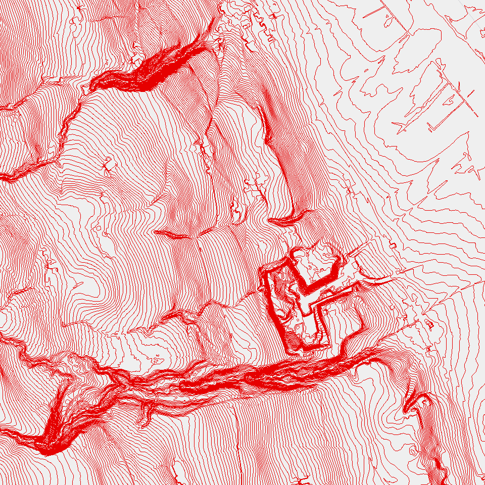
Höhenlinien, 1m, DTM 2018
Auf der Grundlage des digitalen Terrainmodells (DTM) 2018 erstellte 1m-Höhenlinien (Isohypsen)
Simple
- Alternate title
-
DTM18H1M_DS
- Date (Creation)
- 2019-07-26
- Presentation form
- Digital map
- Purpose
-
Visualisierung in Karten, Erfassung von Erschliessungsgebieten, Abgrenzung von Wassereinzugsgebieten, Definition Wasserscheiden etc.HinweisDa im digitalen Terrainmodell DTM keine Interpolation der Terrainwerte bei Gebäudegrundrissen zur Anwendung kommt, verlaufen die Höhenlinien um die Gebäudegrundrisse herum.
- Status
- Completed
Publisher
Owner
- Spatial representation type
- Vector
- Topic category
-
- C Elevation
Extent
Extent
- Description
-
Kanton Luzern
))
- Maintenance and update frequency
- Not planned
- geocat.ch
-
-
opendata.swiss
-
Amtliche Vermessung/AV
-
Geländemodell
-
Topographie
-
Resource constraints
- Access constraints
- none
- Use constraints
- Copyright
Resource constraints
- Use limitation
-
öffentlich zugängliche Geobasisdaten
Resource constraints
- Access constraints
- none
- Use constraints
- none
Resource constraints
- Use limitation
-
Freie Nutzung. Quellenangabe ist Pflicht
- Language
- Deutsch
- Character encoding
- UTF-8
- Included with dataset
- false
- Title
-
DTM18H1M_V2_LI
- Date (Publication)
- 2019-07-26
- Name
-
DTM18H1M_V2_LI
- Scope
-
Linien
- Version
-
V2
- Date
- 2025-09-03
Property description
- Property name
- Linien
- Definition
-
Höhenlinien, 1m, DTM 2018
- Abstract
- false
Elements
- Member name
- AEQ_DIST
- Definition
-
Äquidistanz
- Cardinalities
-
1
- Type name
-
Short Integer
- Codelist
-
Code Label Definition Code Label Definition Value type 0
0.5m-Äquidistanz
0
0.5m-Äquidistanz
1
1m-Äquidistanz
1
1m-Äquidistanz
5
5m-Äquidistanz
5
5m-Äquidistanz
10
10m-Äquidistanz
10
10m-Äquidistanz
50
50m-Äquidistanz
50
50m-Äquidistanz
100
100m-Äquidistanz
100
100m-Äquidistanz
Elements
- Member name
- HOEHE
- Definition
-
Höhe ü. Meer [m]
- Cardinalities
-
1
- Type name
-
Short Integer
Elements
- Member name
- OBJECTID
- Definition
-
OBJECTID
- Cardinalities
-
1
- Type name
-
GUID
Elements
- Member name
- SHAPE
- Definition
-
SHAPE
- Cardinalities
-
1
- Type name
-
SHAPE
Elements
- Member name
- SHAPE.LEN
- Definition
-
SHAPE.LEN
- Cardinalities
-
1
- Type name
-
Double
- Distribution format
-
-
ESRI Geodatabase (.gdb)
-
ESRI Shapefile (.shp)
-
OGC GeoPackage (.gpkg)
-
DXF (.dxf)
-
Point of contact
Digital transfer options
- OnLine resource
-
Datenshop
Produktansicht Geodatenshop
- Statement
-
Abgeleitet von: Digitales Terrainmodell (DTM) 2018
- Geometric object type
- polyline
- Reference system identifier
- EPSG:2056
- Maintenance and update frequency
- Not planned
Metadata
- Metadata identifier
- 08affb1c-67df-4958-86df-35888c3181ff
- Language
- Deutsch
- Character encoding
- UTF-8
Point of contact
Type of resource
- Resource scope
- Dataset
- Metadata linkage
-
https://www.geocat.ch/geonetwork/srv/api/records/08affb1c-67df-4958-86df-35888c3181ff
- Date info (Creation)
- 2019-07-26
- Date info (Revision)
- 2026-06-19T03:21:11.75331Z
Metadata standard
- Title
-
ISO19115.3-2018.che
)))