geocat.ch
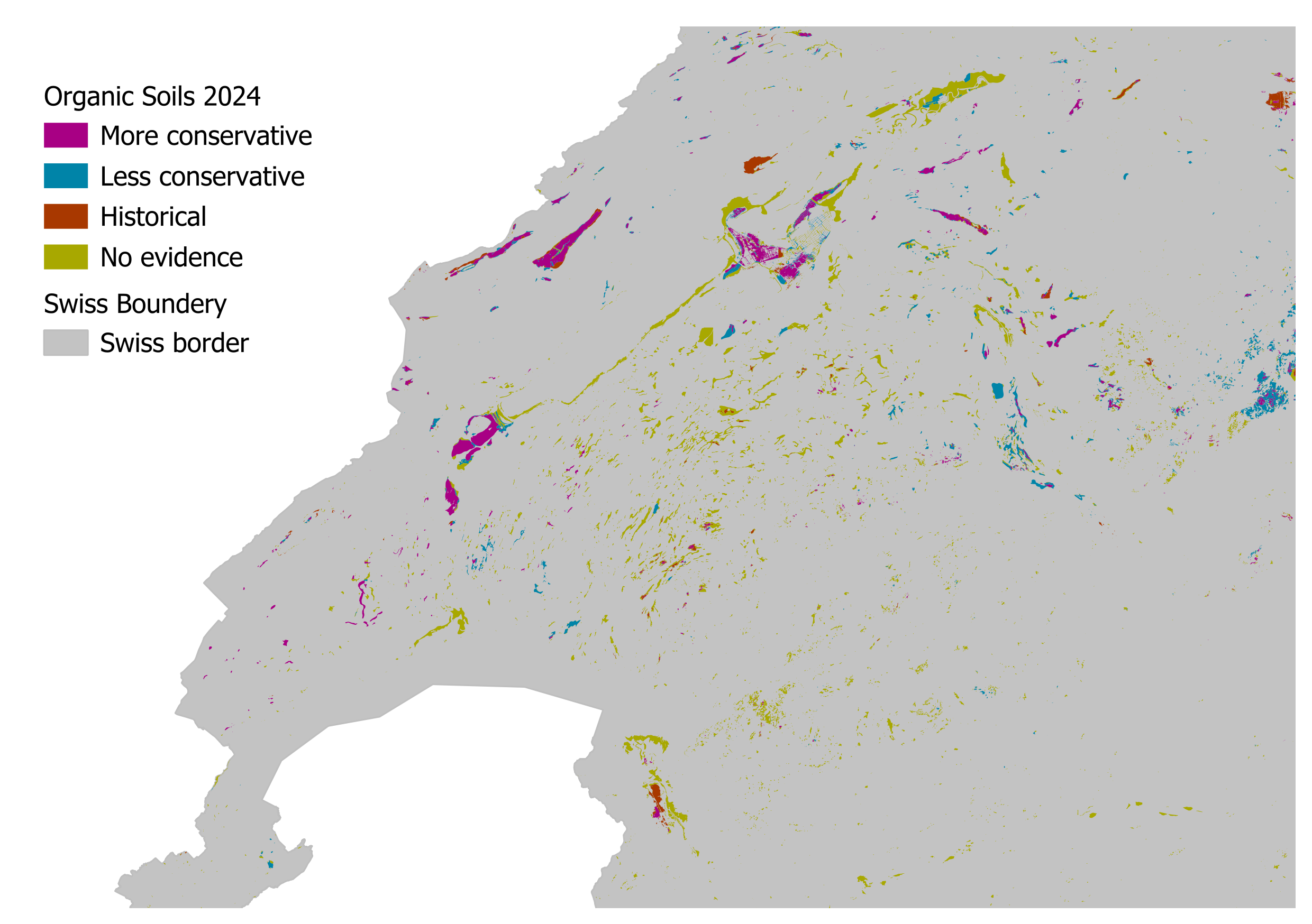
Distribution of organic soils in Switzerland (Agroscope 2025)
The map of organic soils in Switzerland is an update of the first map published in 2015. It provides an estimate of the distribution of (former) moorland soils that still exist today and are sufficiently humus-rich and deep to meet the criteria for organic soil.
<br>
The map was produced in four steps: First, soil maps, geological maps, national inventories of fens, raised bogs and transition mires, forest site maps, historical maps and documents were evaluated. Data newly available since 2015 were also included in this update. In a second step, all data sets were harmonised and incorporated into a data model allowing the various data sets to be combined. In a third step, the spatial data sets were overlaid and a rule-based method was used to identify the resulting surfaces as organic soil or not organic soil. In the final step, reliable information on the occurrence of mineral soils was used to delete surfaces for which the evidence of organic soil was considered less reliable. The total area of organic soils (including the ‘certain’ and ‘less certain’ estimates) is 32,702 ha. For many applications, this is the best estimate of the current occurrence of organic soils. The category ‘only documented in historical sources’ refers to areas for which no current relevant information was found – neither in relation to mineral nor organic soils. The category ‘ambiguously documented’ covers areas for which the evidence of organic soils is unclear; it is shown here solely for reasons of consistency with the previous surface estimate from 2015.
<br>
Due to the heterogeneous nature of the information sources used to create the map, it is not possible to define the scale for which this map is suitable. However, the following recommendation can be made: The map is suitable for use at national and regional levels (e.g. canton or district); it is not suitable for use at parcel level.
<br>
Two publications describe the methods and updated data sets in detail. It is recommended to read both publications before using the map. Parts of the data are subject to a licence; please refer to the ‘readme.txt’ file in the download folder.
<br><br>
Literature
<ul>
<li> Wüst-Galley, C. and J. Leifeld (2025) ‘The distribution and (future) use of Switzerland's organic soils’ Mires and Peat 32(4): 1-17, DOI: 10.19189/001c.130819</li>
<li> Wüst-Galley, C., A. Grünig and J. Leifeld (2015) ‘Locating organic soils for the greenhouse gas inventory’ Agroscope Science 26, 100 pp.</li>
<ul>
Simple
- Alternate title
-
Organic soils CH 2025
- Date (Creation)
- 2024-08
- Date (Publication)
- 2025-04
- Identifier
- ch.agroscope.abschaetzung-organische_boeden
- Status
- Completed
Author
- Spatial representation type
- Vector
Spatial resolution
Equivalent scale
- Denominator
- 100000
- Topic category
-
- F Geoscientific information
Extent
Extent
- Description
-
Switzerland
))

- Maintenance and update frequency
- Unknown
- geocat.ch
-
-
FSDI Federal Spatial Data Infrastructure
-
confederation
-
- GEMET
-
-
bog
-
bog
-
mapping
-
mapping
-
greenhouse gas
-
greenhouse gas
-
waterlogged land
-
climate protection
-
- GEMET themes
-
-
soil
-
Resource constraints
- Classification
- Unclassified
- User note
-
Parts of the data are subject to a licence.
Resource constraints
- Use limitation
-
Zitat Publikation
- Access constraints
- License
- Use constraints
- License
- Other constraints
- Opendata OPEN: Open use.
- Other constraints
- Subject to license (CC BY-SA).
- Language
- Deutsch
- Character encoding
- UTF8
- Subtopic Category
- F2 Soils
- Distribution format
-
-
ESRI File Geodatabase FileGDB (GDB)
-
OGC Geopackage (GPKG)
-
Digital transfer options
- OnLine resource
-
Link zum Projekt
Link to the project
Digital transfer options
- OnLine resource
-
STAC Browser
Link for data download
Digital transfer options
- OnLine resource
-
Vorschau der Karte
Digital transfer options
- OnLine resource
-
Wüst-Galley Leifeld 2025 org soils map.pdf
Link zur Publikation
Digital transfer options
- OnLine resource
-
Wüst-Galley et al 2015 LocatingOrganicSoilsForTheSwissGreenhouseGasInventory.pdf
Publication explaining the data of 2015
Digital transfer options
- OnLine resource
-
Wüst-Galley Leifeld 2025 org soils map SI.pdf
Publication explaining the data of 2024
Digital transfer options
- OnLine resource
-
ch.agroscope.abschaetzung-organische_boeden
WMS-BGDI service, layer "Organic soils CH 2024"
Digital transfer options
- OnLine resource
-
ch.agroscope.abschaetzung-organische_boeden
WMTS-BGDI service, layer "Organic soils CH 2024"
Digital transfer options
- OnLine resource
-
ch.agroscope.abschaetzung-organische_boeden
WMS-FSDI service, layer "Organic soils CH 2024"
Digital transfer options
- OnLine resource
-
Soil_Legende_BGDI_Arial12_Jan26_FR.png
Digital transfer options
- OnLine resource
-
Map_OrganicSoil_DataDescription_DE_Engl_Fr.pdf
- Topology level
- Full planar graph
- Geometric object type
- Surface
- Number of dimensions
- 2
- Cell geometry
- Area
- Reference system identifier
- LV95 EPSG:2056
- Maintenance and update frequency
- Not planned
Metadata
- Metadata identifier
- 0572e842-7e34-409a-90d9-526d012a1c2d
- Language
- Deutsch
- Character encoding
- UTF8
- Language
- Français
- Character encoding
- UTF8
- Language
- Italiano
- Character encoding
- UTF8
- Language
- English
- Character encoding
- UTF8
- Language
- Rumantsch
- Character encoding
- UTF8
Custodian
Type of resource
- Resource scope
- Dataset
- Metadata linkage
-
https://www.geocat.ch/geonetwork/srv/api/records/0572e842-7e34-409a-90d9-526d012a1c2d
- Date info (Creation)
- 2025-04-03T15:19:07.141Z
- Date info (Revision)
- 2026-06-15T09:18:55.325418Z
Metadata standard
- Title
-
eCH-0271