geocat.ch
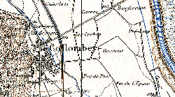
Carte Siegfried (VS)
L'Atlas topographique de la Suisse a été publié entre 1870 et 1926, initialement sous la direction du colonel Hermann Siegfried. Cest la première carte d'ensemble détaillée de la Suisse à l'échelle 1:25'000 pour le Plateau central, le Jura et le sud du Tessin et, au 1:50'000, pour les Alpes. Au total, si l'on tient compte de la mise à jour périodique effectuée jusqu'en 1949, plus de 4000 feuilles mises à jour ont été publiées. Deux techniques différentes ont été appliquées pour lélaboration initiale: la gravure sur cuivre pour les 462 feuilles à l'échelle 1:25'000 et la lithographie pour les 142 feuilles au 1:50000. Toutes les éditions ont été scannées et sont désormais disponibles sous forme numérique pour des analyses du développement du paysage et d'autres applications.
Simple
- Alternate title
-
Carte Siegfried Première édition (VS)
- Date (Creation)
- 1870-01-01
- Identifier
- 203
- Purpose
-
données de référence
- Status
- Historical archive
Custodian
- Spatial representation type
- Grid
Spatial resolution
Equivalent scale
- Denominator
- 50000
Spatial resolution
Equivalent scale
- Denominator
- 25000
- Topic category
-
- A Imagery base maps earth cover
Extent
Extent
- Description
-
Canton of Valais (VS)
))

- Maintenance and update frequency
- Not planned
Resource format
- Title
-
ESRI Enterprise Geodatabase
- Date
- GEMET
-
-
cartography
-
- geocat.ch
-
-
official geodata
-
historic map
-
national map
-
terrain representation
-
topography
-
- GEMET
-
-
map chart
-
Resource constraints
- Use limitation
-
sous licence
Resource constraints
- Access constraints
- Other restrictions
- Other constraints
-
Géodonnées accessibles au public (niveau A selon l'OGéo)
- Other constraints
-
Les conditions générales d'utilisation des géodonnées du Canton du Valais font foi ( https://www.vs.ch/fr/web/guest/information-legale).
- Language
- Français
- Character encoding
- UTF8
- Language
- Deutsch
- Character encoding
- UTF8
- Environment description
-
S:\Géodonnées VS\A1 Cartes de référence\Siegfried 50 1870-1920 Index.lyr S:\Géodonnées VS\A1 Cartes de référence\Siegfried 50 1870-1920.lyr S:\Géodonnées VS\A1 Cartes de référence\Siegfried 25 1870-1920 Index.lyr S:\Géodonnées VS\A1 Cartes de référence\Siegfried 25 1870-1920.lyr
- Subtopic Category
- A1 Base Maps, Landscape Models
- Basic Geodata
- true
- Basic Geodata ID
-
49.1
- Basic Geodata Legal Level
- Federal
- Basic Geodata Type
- basicGeodata referenceGeodata
- Distribution format
-
-
GeoTIFF (GEOTIFF)
-
Cloud Optimized GeoTIFF (TIFF / TIF)
-
Distributor
- Statement
-
Les premières cartes à l'échelle des levés originaux (1:25 000 et 1:50 000) n'ont été publiées qu'à partir de 1870. Toutefois, l'ensemble du pays n'a pas été publié selon une échelle uniforme, ce qui nous fait distinguer deux séries, qui se recoupent en partie.
- Hierarchy level
- Dataset
- Reference system identifier
- EPSG:2056/CH1903+_MN95
Metadata
- Metadata identifier
- 03665b9a-2479-47ab-8cbb-0ecdefc95a38
- Language
- Français
- Character encoding
- UTF8
- Language
- Deutsch
- Character encoding
- UTF8
- Language
- Italiano
- Character encoding
- UTF8
- Language
- English
- Character encoding
- UTF8
- Language
- Rumantsch
- Character encoding
- UTF8
Distributor
Type of resource
- Resource scope
- Dataset
- Metadata linkage
-
https://www.geocat.ch/geonetwork/srv/api/records/03665b9a-2479-47ab-8cbb-0ecdefc95a38
- Date info (Creation)
- 2014-12-16T17:18:30Z
- Date info (Revision)
- 2026-04-13T09:42:09.065082Z
Metadata standard
- Title
-
GM03 2+