geocat.ch
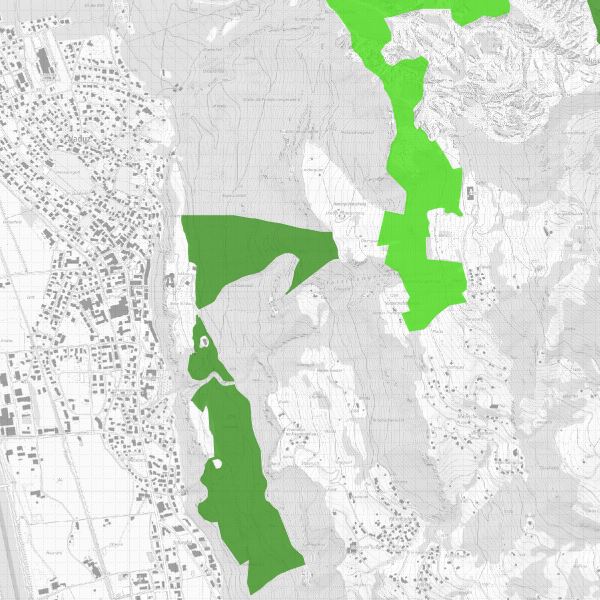
Waldreservate und Sonderwaldflächen
Forest reserves and special forest areas
Waldreservate und Sonderwaldflächen Liechtensteins sind gemäss Waldgesetz (LGBl. 1991 Nr. 42) mit der Verordnung über Waldreservate und Sonderwaldflächen (LGBl. 2000 Nr. 230) geschützt. Waldreservate sind Waldflächen, die der ungestörten, dynamischen Entwicklung überlassen werden. Sonderwaldflächen sind Waldflächen mit vorrangiger Naturschutz- und Landschaftsschutzfunktionen, in denen dem Schutzziel entsprechende Massnahmen durchgeführt werden können.
Forest reserves and special forest areas in Liechtenstein are protected in accordance with the Forest Act (LGBl. 1991 No. 42) and the Ordinance on Forest Reserves and Special Forest Areas (LGBl. 2000 No. 230). Forest reserves are forest areas that are left to undisturbed, dynamic development. Special forest areas are forest areas with priority nature conservation and landscape protection functions in which measures corresponding to the conservation objective can be implemented.
Simple
-
Date (Publication)Data (Pubblicazione)Date (Publication)Datum (Publikation)
- 2006-03-17
-
IdentifiantIdentificatoreIdentifierKennung
- https://metadata.geo.llv.li/02ab142a-7ff2-4dab-abb2-5d79cf2ffcb0
-
ButScopoPurposeZweck
-
Gemäss Art. 12 des Waldgesetzes kann aus ökologischen Erwägungen auf die Bewirtschaftung des Waldes verzichtet werden. Die Regierung hat im Einvernehmen mit den Waldeigentümern Waldreservate ausgeschieden, deren Abgrenzung mit diesem Layer festgelegt wird.
In accordance with Art. 12 of the Forest Act, forest management may be waived for ecological reasons. In agreement with the forest owners, the government has designated forest reserves, the boundaries of which are defined in this layer.
-
ÉtatStatoStatusBearbeitungsstatus
-
ContinuIn corsoOn goingKontinuierliche Aktualisierung
responsable de la publication
Editore
Publisher
Herausgeber
-
Heures de serviceOrario di servizioHours of serviceBetriebszeiten
-
8:00-11:30 und 13:30-17:00
Propriétaire
Proprietario
Owner
Eigentümer
-
Heures de serviceOrario di servizioHours of serviceBetriebszeiten
-
8:00-11:30 und 13:30-17:00
-
Type de représentation spatialeTipo di rappresentazione spazialeSpatial representation typeRäumliche Darstellungsart
-
vecteurVettorialeVectorVektor
Résolution spatiale
Risoluzione spaziale
Spatial resolution
Räumliche Auflösung
-
Distance de résolutionDistanza di risoluzioneSpatial resolutionDistanz
- 1 m
-
Catégorie de thèmeCategoria ISOTopic categoryThematik
-
-
G BioteG BiotaG BiotaG Biologie
-
R Intelligence militaireintelligenceMilitaryR Intelligence militaryR Militär und Aufklärung
-
M SociétéM SocietàM SocietyM Gesellschaft
-
Étendue
Estensione
Extent
Ausdehnung
Étendue
Estensione
Extent
Ausdehnung
-
DescriptionDescrizioneDescriptionBeschreibung
-
Liechtenstein
Liechtenstein
Liechtenstein
Liechtenstein
))

-
Fréquence de mise à jourFrequenza di aggiornamentoMaintenance and update frequencyWartungsintervall
-
InconnueSconosciutoUnknownUnbekannt
Format de la ressource
Formato della risorsa
Resource format
Format der Ressource
-
TitreTitoloTitleTitel
-
INTERLIS 1 (ITF)
-
DateDataDateDatum
Format de la ressource
Formato della risorsa
Resource format
Format der Ressource
-
TitreTitoloTitleTitel
-
ESRI Shapefile (SHP)
-
DateDataDateDatum
- GEMET
-
-
bois
bosco
wood
-
préservation de la nature
conservazione della natura
nature conservation
-
- GEMET - INSPIRE themes, version 1.0
-
-
Habitats et biotopes
Habitat e biotopi
Habitats and biotopes
-
Sites protégés
Siti protetti
Protected sites
-
- geocat.ch
-
-
nature
natura
nature
-
INSPIRE
INSPIRE
INSPIRE
-
OpenData
OpenData
OpenData
-
- Räumlicher Anwendungsbereich
-
-
Nationales
Nazionali
National
-
- GEMET
-
-
Landschaft
paysage
paesaggio
landscape
-
Contraintes sur la ressource
Vincoli sulle risorse
Resource constraints
Ressourcenbeschränkungen
-
Limitation d'utilisationLimitazione d'usoUse limitationNutzungsbeschränkung
-
keine
-
Contraintes d'accèsVincoli di accessoAccess constraintsZugriffsbeschränkungen
-
Autres restrictionsAltre restrizioniOther restrictionsAndere Beschränkungen
-
Contraintes d'utilisationVincoli d'usoUse constraintsNutzungseinschränkungen
-
Autres restrictionsAltre restrizioniOther restrictionsAndere Beschränkungen
-
Autres contraintesAltri vincoliOther constraintsAndere Einschränkungen
- No limitations to public accessNo limitations to public accessNo limitations to public accessNo limitations to public access
Contraintes sur la ressource
Vincoli sulle risorse
Resource constraints
Ressourcenbeschränkungen
-
Contraintes d'accèsVincoli di accessoAccess constraintsZugriffsbeschränkungen
-
Autres restrictionsAltre restrizioniOther restrictionsAndere Beschränkungen
-
Contraintes d'utilisationVincoli d'usoUse constraintsNutzungseinschränkungen
-
Autres restrictionsAltre restrizioniOther restrictionsAndere Beschränkungen
-
Autres contraintesAltri vincoliOther constraintsAndere Einschränkungen
- No conditions to access and useNo conditions to access and useNo conditions to access and useNo conditions to access and use
-
Autres contraintesAltri vincoliOther constraintsAndere Einschränkungen
- Opendata BY: Freie Nutzung. Quellenangabe ist Pflicht.Opendata BY: Utilisation libre. Obligation d’indiquer la source.Opendata BY: Libero utilizzo. Indicazione della fonte obbligatoria.Opendata BY: Open use. Must provide the source.
-
LangueLinguaLanguageSprache
- Deutsch
-
Encodage de caractèresCodifica dei caratteriCharacter encodingZeichenkodierung
-
Utf8UTF8UTF8Utf8
-
LangueLinguaLanguageSprache
- Deutsch
-
Livré avec jeu de donnéesFornito con set di datiIncluded with datasetMit Datensatz geliefert
- 0
-
TitreTitoloTitleTitel
-
Datenmodell Waldreservate und Sonderwaldflächen
-
Date (Création)Data (Creazione)Date (Creation)Datum (Erstellung)
- 2012-01-16
-
Format de distributionFormato (codifica)Distribution formatAbgabeformat
-
-
INTERLIS 1 (ITF)
-
AutoCAD DXF (DXF)
-
ESRI Shapefile (SHP)
-
Point de contact
Punto di contatto
Point of contact
Ansprechpartner
-
Heures de serviceOrario di servizioHours of serviceBetriebszeiten
-
8:00-11:30 und 13:30-17:00
Options de transfert numérique
Opzioni di trasferimento digitale
Digital transfer options
Optionen für die digitale Übertragung
-
Ressource en ligneRisorsa onlineOnLine resourceOnline
-
Geodatenportal der Landesverwaltung
Geodatenportal der Liechtensteinischen Landesregierung.Geodata portal of the National Administration
Options de transfert numérique
Opzioni di trasferimento digitale
Digital transfer options
Optionen für die digitale Übertragung
-
Ressource en ligneRisorsa onlineOnLine resourceOnline
-
li.au.nl_waldreservat_sonderwald
OGC WMS Service der Liechtensteinen LandesverwaltungOGC WMS Service der Liechtensteinen Landesverwaltung
Options de transfert numérique
Opzioni di trasferimento digitale
Digital transfer options
Optionen für die digitale Übertragung
-
Ressource en ligneRisorsa onlineOnLine resourceOnline
-
Zip Download über das Geodatenportal
Zip Download über das GeodatenportalZip download via the geodata portal
-
NiveauLivelloHierarchy levelBezugsebene
-
Jeu de donnéesSet di datiDatasetDatenbestand
Rapport sur la qualité
Rapporto sulla qualità
Report
Qualitätsbericht
Result
Risultato
Result
Ergebnis
-
TitreTitoloTitleTitel
-
VERORDNUNG (EG) Nr. 1089/2010 DER KOMMISSION vom 23. November 2010 zur Durchführung der Richtlinie 2007/2/EG des Europäischen Parlaments und des Rates hinsichtlich der Interoperabilität von Geodatensätzen und -diensten
-
Date (Publication)Data (Pubblicazione)Date (Publication)Datum (Publikation)
- 2010-12-08
-
ExplicationSpiegazioneExplanationErläuterung
-
Gemäss Inspire-Bestandteil des Themas Schutzgebiete
-
Degré de conformitéGrado di conformitàPassKonformitätsgrad
- false
-
Généralités sur la provenanceInformazioni generali sulla provenienzaStatementErklärung
-
Digitalisiert ab Landeskarte 1:10'000 resp 1:25'000
Digitised from national map 1:10,000 resp. 1:25,000
-
NiveauLivelloHierarchy levelBezugsebene
-
Jeu de donnéesSet di datiDatasetDatenbestand
-
Niveau de topologieLivello di topologiaTopology levelTopologieebene
-
Topologie de réseau complèteGrafo planare completoFull planar graphVollständige Netzwerktopologie
-
Type d’objet géométriqueTipo di oggetto geometricoGeometric object typeTyp des geometrischen Objekts
-
PolygoneSuperficieSurfacesurface
-
Nombre d’objets géométriquesNumero di oggetti geometriciGeometric object countAnzahl geometrischer Objekte
- 146
-
Nom du système de référenceNome del sistema di riferimentoReference system identifierName des Referenzsystems
- http://www.opengis.net/def/crs/EPSG/0/2056
-
Nom du système de référenceNome del sistema di riferimentoReference system identifierName des Referenzsystems
- http://www.opengis.net/def/crs/EPSG/0/4936
Metadata
-
Identifiant des métadonnéesIdentificativo della schedaMetadata identifierIdentifikator des Metadatensatzes
- 02ab142a-7ff2-4dab-abb2-5d79cf2ffcb0
-
LangueLinguaLanguageSprache
- Deutsch
-
Encodage de caractèresCodifica dei caratteriCharacter encodingZeichenkodierung
-
Utf8UTF8UTF8Utf8
-
LangueLinguaLanguageSprache
- Français
-
Encodage de caractèresCodifica dei caratteriCharacter encodingZeichenkodierung
-
Utf8UTF8UTF8Utf8
-
LangueLinguaLanguageSprache
- Italiano
-
Encodage de caractèresCodifica dei caratteriCharacter encodingZeichenkodierung
-
Utf8UTF8UTF8Utf8
-
LangueLinguaLanguageSprache
- English
-
Encodage de caractèresCodifica dei caratteriCharacter encodingZeichenkodierung
-
Utf8UTF8UTF8Utf8
Point de contact
Punto di contatto
Point of contact
Ansprechpartner
-
Heures de serviceOrario di servizioHours of serviceBetriebszeiten
-
8:00-11:30 und 13:30-17:00
Type de ressource
Tipo di risorsa
Type of resource
Anwendungsbereich der Metadaten
-
Domaine d'application de la ressourceAmbito di applicazione della risorsaResource scopeDomäne der Ressourcenanwendung
-
Jeu de donnéesSet di datiDatasetDatenbestand
-
Informations de date (Création)Informazioni sulla data (Creazione)Date info (Creation)Datumsangaben (Erstellung)
- 2006-03-17T12:00:00Z
-
Informations de date (Révision)Informazioni sulla data (Revisione)Date info (Revision)Datumsangaben (Aktualisierung)
- 2026-04-13T09:33:54.496001Z
Norme des métadonnées
Standard dei metadati
Metadata standard
Metadatenstandard
-
TitreTitoloTitleTitel
-
eCH-0271