geocat.ch
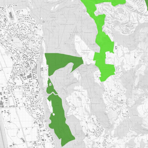
Forest reserves and special forest areas
Forest reserves and special forest areas in Liechtenstein are protected in accordance with the Forest Act (LGBl. 1991 No. 42) and the Ordinance on Forest Reserves and Special Forest Areas (LGBl. 2000 No. 230). Forest reserves are forest areas that are left to undisturbed, dynamic development. Special forest areas are forest areas with priority nature conservation and landscape protection functions in which measures corresponding to the conservation objective can be implemented.
Simple
- Date (Publication)
- 2006-03-17
- Identifier
- https://metadata.geo.llv.li/02ab142a-7ff2-4dab-abb2-5d79cf2ffcb0
- Purpose
-
In accordance with Art. 12 of the Forest Act, forest management may be waived for ecological reasons. In agreement with the forest owners, the government has designated forest reserves, the boundaries of which are defined in this layer.
- Status
- On going
Publisher
- Hours of service
-
8:00-11:30 und 13:30-17:00
Owner
- Hours of service
-
8:00-11:30 und 13:30-17:00
- Spatial representation type
- Vector
Spatial resolution
- Spatial resolution
- 1 m
- Topic category
-
- G Biota
- R Intelligence military
- M Society
Extent
Extent
- Description
-
Liechtenstein
))

- Maintenance and update frequency
- Unknown
Resource format
- Title
-
INTERLIS 1 (ITF)
- Date
Resource format
- Title
-
ESRI Shapefile (SHP)
- Date
- GEMET
-
-
wood
-
nature conservation
-
- GEMET - INSPIRE themes, version 1.0
-
-
Habitats and biotopes
-
Protected sites
-
- geocat.ch
-
-
nature
-
INSPIRE
-
OpenData
-
- Räumlicher Anwendungsbereich
-
-
National
-
- GEMET
-
-
landscape
-
Resource constraints
- Use limitation
-
keine
- Access constraints
- Other restrictions
- Use constraints
- Other restrictions
- Other constraints
- No limitations to public access
Resource constraints
- Access constraints
- Other restrictions
- Use constraints
- Other restrictions
- Other constraints
- No conditions to access and use
- Other constraints
- Opendata BY: Open use. Must provide the source.
- Language
- Deutsch
- Character encoding
- UTF8
- Language
- Deutsch
- Included with dataset
- 0
- Title
-
Datenmodell Waldreservate und Sonderwaldflächen
- Date (Creation)
- 2012-01-16
- Distribution format
-
-
INTERLIS 1 (ITF)
-
AutoCAD DXF (DXF)
-
ESRI Shapefile (SHP)
-
Point of contact
- Hours of service
-
8:00-11:30 und 13:30-17:00
Digital transfer options
- OnLine resource
-
Geodatenportal der Landesverwaltung
Geodata portal of the National Administration
Digital transfer options
- OnLine resource
-
li.au.nl_waldreservat_sonderwald
OGC WMS Service der Liechtensteinen Landesverwaltung
Digital transfer options
- OnLine resource
-
Zip Download über das Geodatenportal
Zip download via the geodata portal
- Hierarchy level
- Dataset
Report
Result
- Title
-
VERORDNUNG (EG) Nr. 1089/2010 DER KOMMISSION vom 23. November 2010 zur Durchführung der Richtlinie 2007/2/EG des Europäischen Parlaments und des Rates hinsichtlich der Interoperabilität von Geodatensätzen und -diensten
- Date (Publication)
- 2010-12-08
- Explanation
-
Gemäss Inspire-Bestandteil des Themas Schutzgebiete
- Pass
- false
- Statement
-
Digitised from national map 1:10,000 resp. 1:25,000
- Hierarchy level
- Dataset
- Topology level
- Full planar graph
- Geometric object type
- Surface
- Geometric object count
- 146
- Reference system identifier
- http://www.opengis.net/def/crs/EPSG/0/2056
- Reference system identifier
- http://www.opengis.net/def/crs/EPSG/0/4936
Metadata
- Metadata identifier
- 02ab142a-7ff2-4dab-abb2-5d79cf2ffcb0
- Language
- Deutsch
- Character encoding
- UTF8
- Language
- Français
- Character encoding
- UTF8
- Language
- Italiano
- Character encoding
- UTF8
- Language
- English
- Character encoding
- UTF8
Point of contact
- Hours of service
-
8:00-11:30 und 13:30-17:00
Type of resource
- Resource scope
- Dataset
- Metadata linkage
-
https://www.geocat.ch/geonetwork/srv/api/records/02ab142a-7ff2-4dab-abb2-5d79cf2ffcb0
- Date info (Creation)
- 2006-03-17T12:00:00Z
- Date info (Revision)
- 2026-04-13T09:33:54.496001Z
Metadata standard
- Title
-
eCH-0271