geocat.ch
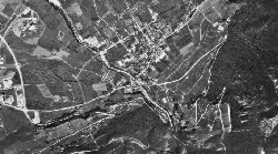
Orthophotos 1980
Mosaïque d'orthophotos de 1980, n/b
Simple
- Alternate title
-
Orthophotos 1980
- Date (Creation)
- 2012-11-20
- Identifier
- 242
- Purpose
-
Mise à disposition des photos aériennes prises dans le cadre de l'élaboration du plan directeur cantonal de 1988
- Status
- Historical archive
Custodian
- Spatial representation type
- Grid
Spatial resolution
- Spatial resolution
- 0.8 m
- Topic category
-
- A Imagery base maps earth cover
Extent
Extent
- Description
-
Canton of Valais (VS)
))

- Maintenance and update frequency
- Not planned
Resource format
- Title
-
Tagged Image File Format (TIFF)
- Date
- GEMET - INSPIRE themes, version 1.0
-
-
Orthoimagery
-
- GEMET
-
-
history
-
- geocat.ch
-
-
official geodata
-
Resource constraints
- Use limitation
-
Aucunes
Resource constraints
- Access constraints
- Other restrictions
- Other constraints
-
Géodonnées accessibles au public (niveau A selon l'OGéo)
- Other constraints
-
Les conditions générales d'utilisation des géodonnées du Canton du Valais font foi ( https://www.vs.ch/fr/web/guest/information-legale).
- Language
- Français
- Character encoding
- UTF8
- Environment description
-
S:\Géodonnées VS\A3 Images\Orthophoto 1980.lyr, S:\Géodonnées VS\A3 Images\Orthophoto 1980 Index.lyr
- Subtopic Category
- A3 Aerial and Satellite Imagery
- Basic Geodata
- false
- Basic Geodata Legal Level
- Cantonal
- Basic Geodata Type
- Reference Geodata
- Distribution format
-
-
GeoTIFF (GEOTIFF)
-
Cloud Optimized GeoTIFF (TIFF / TIF)
-
Distributor
- Statement
-
Photos aériennes analogues de Swisstopo
- Hierarchy level
- Dataset
- Description
-
Scannage et orthorectification à l'aide des données LIDAR de 2005
- Reference system identifier
- EPSG:2056/CH1903+_MN95
Metadata
- Metadata identifier
- 004ff1f9-f245-4517-ad82-e4a71cf23371
- Language
- Français
- Character encoding
- UTF8
- Language
- Deutsch
- Character encoding
- UTF8
- Language
- Italiano
- Character encoding
- UTF8
- Language
- English
- Character encoding
- UTF8
- Language
- Rumantsch
- Character encoding
- UTF8
Distributor
Type of resource
- Resource scope
- Dataset
- Metadata linkage
-
https://www.geocat.ch/geonetwork/srv/api/records/004ff1f9-f245-4517-ad82-e4a71cf23371
- Date info (Creation)
- 2016-08-22T14:03:01Z
- Date info (Revision)
- 2026-05-18T12:04:07.387964Z
Metadata standard
- Title
-
eCH-0271