geocat.ch
MNT-MO modèle numérique de terrain de la mensuration officielle (VS)
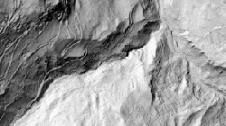
MNT-MO (brut) est le modèle numérique de terrain de la mensuration officielle avec les mesures brutes et MNT-MO (grid2) est la grille régulière avec un espacement de 2m établie par interpolation à partir du MNT-MO (brut). Il reproduit le terrain nu, sans végétation ni constructions. Les données ne sont disponibles qu'en dessous de 2000 mètres d'atlitude. Les données sont partie intégrante de la mensuration officielle.
Simple
- Alternate title
-
MNT-MO (VS)
- Date (Creation)
- 2005-01-01
- Identifier
- 165,201 et 224
- Purpose
-
! Produit remplacé par swissALTI3D ! La gamme des applications de MNT-MO s'étend à toutes les utilisations requérant une modélisation précise de la surface terrestre, par exemple dans les domaines suivants : base pour la production d'orthophotos, dangers naturels, télécommunications, visualisation 3D.
- Status
- Obsolete
Custodian
- Spatial representation type
- Grid
Spatial resolution
- Spatial resolution
- 2 m
- Topic category
-
- C Elevation
Extent
Extent
- Description
-
Canton of Valais (VS)
))

- Maintenance and update frequency
- Not planned
Resource format
- Title
-
ESRI Enterprise Geodatabase
- Date
- GEMET
-
-
altitude
-
laser
-
- geocat.ch
-
-
official geodata
-
digital terrain model DTM
-
laserscanning
-
DEM (digital elevation model)
-
Resource constraints
- Use limitation
-
sous licence
Resource constraints
- Access constraints
- Other restrictions
- Other constraints
-
Géodonnées accessibles au public (niveau A selon l'OGéo)
- Other constraints
-
Les conditions générales d'utilisation des géodonnées du Canton du Valais font foi ( https://www.vs.ch/fr/web/guest/information-legale).
- Language
- Deutsch
- Character encoding
- UTF8
- Supplemental Information
-
Produits dérivés: carte de pente, carte d'exposition, carte du relief, courbes de niveau
- Basic Geodata
- true
- Basic Geodata ID
-
41.2
- Basic Geodata Legal Level
- Federal
- Basic Geodata Type
- Reference Geodata
- Distribution format
-
-
GeoTIFF (GEOTIFF)
-
Cloud Optimized GeoTIFF (TIFF / TIF)
-
Distributor
- Statement
-
Données saisies par swisstopo dans le cadre du projet SAU. Basé sur des mesures laser de haute précision (LIDAR). Précision altimétrique (écart type) ±50 cm. Densité moyenne des points : 1 point pour 2 m2 en zone ouverte.
- Hierarchy level
- Dataset
- Description
-
Lors de la production au laser, des lacunes dans les données dues à la nature de la surface sont parfois apparues. Ces lacunes ont été complététes manuellement afin qu'au minimum 95% des constructions soient illustrées dans le MNS.
- Reference system identifier
- EPSG:21781/CH1903_MN03
Metadata
- Metadata identifier
- fd34801c-1f9a-46bc-baeb-d86fd7c7012c
- Language
- Français
- Character encoding
- UTF8
- Language
- Deutsch
- Character encoding
- UTF8
- Language
- Italiano
- Character encoding
- UTF8
- Language
- English
- Character encoding
- UTF8
- Language
- Rumantsch
- Character encoding
- UTF8
Distributor
Type of resource
- Resource scope
- Dataset
- Metadata linkage
-
https://www.geocat.ch/geonetwork/srv/api/records/fd34801c-1f9a-46bc-baeb-d86fd7c7012c
- Date info (Creation)
- 2016-08-02T12:54:18Z
- Date info (Revision)
- 2026-05-18T12:01:19.962697Z
Metadata standard
- Title
-
eCH-0271