geocat.ch
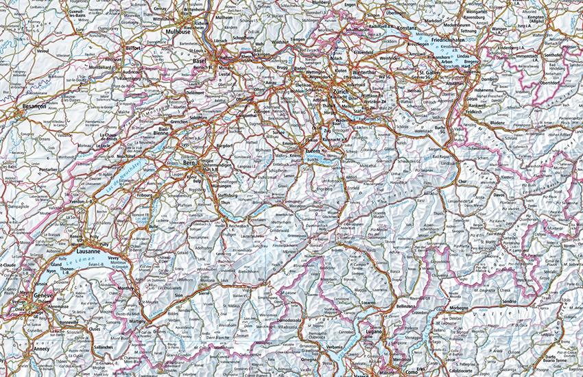
Landeskarten der Schweiz (farbig)
Cartes nationales de la Suisse (couleur)
Carte nazionali della Svizzera (a colori)
National maps of Switzerland (color)
Charta naziunala da la Svizra (colur)
swisstopo erstellt Landeskarten in den Massstäben 1:10‘000 bis 1:1 Million. Der Layer Landeskarten (farbig) nutzt die unterschiedlichen Massstäbe und zeigt die geeignetste Karte in Abhängigkeit der gewählten Zoomstufe an. Der Layer Landeskarte (farbig) dient als Hintergrundkarte im Geoportal des Bundes. Er ist auch in den Geodiensten WMS und WMTS verfügbar. Einmal jährlich wird eine Kopie der WMTS-Kachelpyramide im JPEG-Format und Web-Mercator-Koordinatensystem (EPSG:3857) bis Zoom Level/Tile Matrix 18 (0,5 m Auflösung) zum Download bereitgestellt.
swisstopo produit des cartes nationales à différentes échelles qui vont du 1:10'000 au 1:1 million. La couche cartes nationales (couleur) combine les différentes échelles et affiche la carte la plus adaptée en fonction du niveau de zoom. La couche cartes nationales (couleur) sert de fond de carte au géoportail fédéral. Elle est également disponible en géoservice WMS, WMTS. Une fois par année, une copie de la pyramide des tuiles WMTS est publiée en téléchargement au format JPEG et dans le système de coordonnées Web Mercator (EPSG:3857) jusqu’au zoom level/tile matrix 18 (0.5 m de résolution),
swisstopo produce delle carte nazionali a diverse scale tra 1:10'000 fino a 1:1 milione. Il layer carte nazionali (a colori) combina le diverse scale e mostra, al momento della visualizzazione, la carta più adatta in funzione del livello di zoom. Il layer carte nazionali (a colori) è utilizzato come carta di fondo per il geoportale federale. La carta nazionale è inoltre disponibile come geoservizio WMS e WMTS. Una volta all'anno viene resa disponibile per il download una copia della matrice delle tessere WMTS in formato JPEG e nel sistema di coordinate Web Mercator (EPSG:3857) fino al zoom level/tile matrix 18 (risoluzione di 0,5 m).
swisstopo produces national maps in the scales 1:10'000 up to 1:1 Million. The layer National maps (color) combines the different maps and shows the best fitted map for each zoom level. The layer National maps (color) is used as base map in the swiss federal geoportal. It is also available as WMS and WMTS geoservices. Once a year, a copy of the WMTS tile pyramid is made available for download in JPEG format and in the Web Mercator coordinate system (EPSG:3857) up to zoom level/tile matrix 18 (0.5 m resolution).
swisstopo fa chartas naziunalas en las scalas 1:10'000 fin 1:1 milliun. Il layer "Chartas naziunalas (en colur)" utilisescha las differentas scalas e mussa la charta la pli adattada dal stgalim da zoom tschernì. Il layer "Charta naziunala (en colur)" serva sco charta da fund en il geoportal da la Confederaziun. El è er disponibel en ils geoservetschs WMS e WMTS.
Simple
-
Autre titreAltri nomi o acronimiAlternate titleAlternate titleAlternativtitel
-
Landeskarten (farbig)
Cartes nationales (couleur)
Carte nazionali (colori)
National Maps (color)
Chartas naziunalas (colur)
-
Date (Création)Data (Creazione)Date (Creation)Date (Creation)Datum (Erstellung)
- 2010-01-01
-
IdentifiantIdentificatoreIdentifierIdentifierKennung
- ch.swisstopo.pixelkarte-farbe
-
Forme de la présentationForma della presentazionePresentation formPresentation formPräsentationsform
-
Carte numériqueMappa digitaleDigital mapDigital mapDigitale Karte
-
ButScopoPurposePurposeZweck
-
Georeferenzdaten des Bundesrechts
Géodonnées de référence relevant du droit fédéral
Geodati di riferimento del diritto federale
-
ÉtatStatoStatusStatusBearbeitungsstatus
-
ContinuIn corsoOn goingOn goingKontinuierliche Aktualisierung
Point de contact
Punto di contatto
Point of contact
Point of contact
Ansprechpartner
Propriétaire
Proprietario
Owner
Owner
Eigentümer
-
Type de représentation spatialeTipo di rappresentazione spazialeSpatial representation typeSpatial representation typeRäumliche Darstellungsart
-
grilleRasterGridGridRaster, Gitter
Résolution spatiale
Risoluzione spaziale
Spatial resolution
Spatial resolution
Räumliche Auflösung
Fraction représentative
Frazione rappresentativa
Equivalent scale
Equivalent scale
Vergleichsmassstab
-
DénominateurDenominatoreDenominatorDenominatorMassstabszahl
- 10000
-
Catégorie de thèmeCategoria ISOTopic categoryTopic categoryThematik
-
-
A Imagerie, cartes de base et occupation du solA Mappe di base con immagini della copertura terrestreA Imagery base maps earth coverA Imagery base maps earth coverA Oberflächenbeschreibung
-
Étendue
Estensione
Extent
Extent
Ausdehnung
Étendue
Estensione
Extent
Extent
Ausdehnung
-
DescriptionDescrizioneDescriptionDescriptionBeschreibung
-
Switzerland
Schweiz
Suisse
Svizzera
Svizra
))

Étendue
Estensione
Extent
Extent
Ausdehnung
Étendue
Estensione
Extent
Extent
Ausdehnung
-
DescriptionDescrizioneDescriptionDescriptionBeschreibung
-
Liechtenstein
Liechtenstein
Liechtenstein
Liechtenstein
Liechtenstein
))

-
Fréquence de mise à jourFrequenza di aggiornamentoMaintenance and update frequencyMaintenance and update frequencyWartungsintervall
-
InconnueSconosciutoUnknownUnknownUnbekannt
Format de la ressource
Formato della risorsa
Resource format
Resource format
Format der Ressource
-
TitreTitoloTitleTitleTitel
-
Tagged Image File Format (TIFF)
-
DateDataDateDateDatum
- GEMET themes
-
-
géographie
geografia
geography
-
- GEMET
-
-
eaux (géographie)
acque (geografia)
water (geographic)
-
relief
rilievo
relief (land)
-
cartographie
cartografia
cartography
-
bordure
frontiera
border
-
végétation
vegetazione
vegetation
-
- geocat.ch
-
-
réseau de transport
rete di trasporto
traffic network
-
carte nationale
carta nazionale
national map
-
représentation du terrain
rappresentazione del terreno
terrain representation
-
- geocat.ch
-
-
BGDI Bundesgeodaten-Infrastruktur
IFDG l’Infrastructure Fédérale de données géographiques
IFDG Infrastruttura federale dei dati geografici
FSDI Federal Spatial Data Infrastructure
-
- geocat.ch
-
-
Topografie
topographie
topografia
topography
-
- GEMET
-
-
Karte
cartogramme
mappa
map chart
-
Ressource associée
Risorsa associata
Associated resource
Associated resource
Verlinkte Ressource
-
TitreTitoloTitleTitleTitel
-
Landeskartenwerk 1:10'000 bis 1:1 Mio.
Cartes nationales du 1:10'000 au 1:1'000'000
Carte nazionali 1:10'000 - 1:1 mio.
National Maps 1:10'000 - 1:1 mio.
Charta naziunala 1:10'000 - 1:1 mio.
-
Type d'associationTipo di associazioneAssociation TypeAssociation TypeAssoziationstyp
-
Citation de travail plus largeCitazione di un'opera più ampiaReference to a master resource of which this one is a partReference to a master resource of which this one is a partÜbergeordneter Datenbestand
-
LangueLinguaLanguageLanguageSprache
- Deutsch
-
Encodage de caractèresCodifica dei caratteriCharacter encodingCharacter encodingZeichenkodierung
-
Utf8UTF8UTF8UTF8Utf8
-
LangueLinguaLanguageLanguageSprache
- Français
-
Encodage de caractèresCodifica dei caratteriCharacter encodingCharacter encodingZeichenkodierung
-
Utf8UTF8UTF8UTF8Utf8
-
LangueLinguaLanguageLanguageSprache
- Italiano
-
Encodage de caractèresCodifica dei caratteriCharacter encodingCharacter encodingZeichenkodierung
-
Utf8UTF8UTF8UTF8Utf8
-
LangueLinguaLanguageLanguageSprache
- Rumantsch
-
Encodage de caractèresCodifica dei caratteriCharacter encodingCharacter encodingZeichenkodierung
-
Utf8UTF8UTF8UTF8Utf8
-
Catégorie de sous-thèmeCategoria di sottotemaSubtopic CategorySubtopic CategoryThematische Unterkategorien
-
A1 Cartes de base, modèles de paysageA1 Mappe di base, modelli paesaggisticiA1 Base Maps, Landscape ModelsA1 Base Maps, Landscape ModelsA1 Basiskarten, Landschaftsmodelle
-
Géodonnées de baseGeodati di baseBasic GeodataBasic GeodataGeobasisdaten
- true
-
Identifiant Géodonnées de baseIdentificativo dei geodati di baseBasic Geodata IDBasic Geodata IDIdentifikator des Geobasisdatensatzes
-
42
-
Niveau des géodonnées de baseLivello legale dei geodati di baseBasic Geodata Legal LevelBasic Geodata Legal LevelGeobasisdatenebene
-
FédéralFederaleFederalFederalNational
-
Format de distributionFormato (codifica)Distribution formatDistribution formatAbgabeformat
-
-
Tagged Image File Format (TIFF)
-
Point de contact
Punto di contatto
Point of contact
Point of contact
Ansprechpartner
-
TitreTitoloTitleTitleTitel
-
Tagged Image File Format (TIFF)
-
DateDataDateDateDatum
Options de transfert numérique
Opzioni di trasferimento digitale
Digital transfer options
Digital transfer options
Optionen für die digitale Übertragung
-
Ressource en ligneRisorsa onlineOnLine resourceOnLine resourceOnline
-
Produktinformation Swiss Map Raster
Options de transfert numérique
Opzioni di trasferimento digitale
Digital transfer options
Digital transfer options
Optionen für die digitale Übertragung
-
Ressource en ligneRisorsa onlineOnLine resourceOnLine resourceOnline
-
ch.swisstopo.pixelkarte-farbe
National Maps (color)
Options de transfert numérique
Opzioni di trasferimento digitale
Digital transfer options
Digital transfer options
Optionen für die digitale Übertragung
-
Ressource en ligneRisorsa onlineOnLine resourceOnLine resourceOnline
-
ch.swisstopo.pixelkarte-farbe
National Maps (color)
Options de transfert numérique
Opzioni di trasferimento digitale
Digital transfer options
Digital transfer options
Optionen für die digitale Übertragung
-
Ressource en ligneRisorsa onlineOnLine resourceOnLine resourceOnline
-
map.geo.admin.ch preview
Options de transfert numérique
Opzioni di trasferimento digitale
Digital transfer options
Digital transfer options
Optionen für die digitale Übertragung
-
Ressource en ligneRisorsa onlineOnLine resourceOnLine resourceOnline
-
STAC Browser
Das unkomprimierte tar Archiv enthält die Webmercator (EPSG:3857) WMTS Pyramide bis zu einer Auflösung von 0.5m bzw Zoomlevel/Tilematrix 18.L'archive tar non compressée contient la pyramide WMTS Webmercator (EPSG:3857) jusqu'à une résolution de 0,5 m ou un zoom level/ tile matrix 18.The uncompressed tar archive contains the WebMercator (EPSG:3857) WMTS pyramid up to a resolution of 0.5 m or zoom level/tile matrix 18.
-
Nom du système de référenceNome del sistema di riferimentoReference system identifierReference system identifierName des Referenzsystems
- CH1903+
Metadata
-
Identifiant des métadonnéesIdentificativo della schedaMetadata identifierMetadata identifierIdentifikator des Metadatensatzes
- f9c31be1-887c-4203-8b11-57b40ecc039b
-
LangueLinguaLanguageLanguageSprache
- Deutsch
-
Encodage de caractèresCodifica dei caratteriCharacter encodingCharacter encodingZeichenkodierung
-
Utf8UTF8UTF8UTF8Utf8
-
LangueLinguaLanguageLanguageSprache
- Français
-
Encodage de caractèresCodifica dei caratteriCharacter encodingCharacter encodingZeichenkodierung
-
Utf8UTF8UTF8UTF8Utf8
-
LangueLinguaLanguageLanguageSprache
- Italiano
-
Encodage de caractèresCodifica dei caratteriCharacter encodingCharacter encodingZeichenkodierung
-
Utf8UTF8UTF8UTF8Utf8
-
LangueLinguaLanguageLanguageSprache
- English
-
Encodage de caractèresCodifica dei caratteriCharacter encodingCharacter encodingZeichenkodierung
-
Utf8UTF8UTF8UTF8Utf8
-
LangueLinguaLanguageLanguageSprache
- Rumantsch
-
Encodage de caractèresCodifica dei caratteriCharacter encodingCharacter encodingZeichenkodierung
-
Utf8UTF8UTF8UTF8Utf8
Point de contact
Punto di contatto
Point of contact
Point of contact
Ansprechpartner
-
Heures de serviceOrario di servizioHours of serviceHours of serviceBetriebszeiten
-
08h30 - 11h00 / 14h00 - 16h00 GMT+1
Type de ressource
Tipo di risorsa
Type of resource
Type of resource
Anwendungsbereich der Metadaten
-
Domaine d'application de la ressourceAmbito di applicazione della risorsaResource scopeResource scopeDomäne der Ressourcenanwendung
-
Jeu de donnéesSet di datiDatasetDatasetDatenbestand
-
Lien vers la métadonnéeCollegamento ai metadatiMetadata linkageMetadata linkageLink zu den Metadaten
-
https://www.geocat.ch/geonetwork/srv/api/records/f9c31be1-887c-4203-8b11-57b40ecc039b
-
Informations de date (Création)Informazioni sulla data (Creazione)Date info (Creation)Date info (Creation)Datumsangaben (Erstellung)
- 2016-05-13T15:20:28Z
-
Informations de date (Révision)Informazioni sulla data (Revisione)Date info (Revision)Date info (Revision)Datumsangaben (Aktualisierung)
- 2026-04-13T09:16:22.815789Z
Norme des métadonnées
Standard dei metadati
Metadata standard
Metadata standard
Metadatenstandard
-
TitreTitoloTitleTitleTitel
-
GM03 2+