geocat.ch
Division of Geological Vector Datasets swissGEOCOVER2D
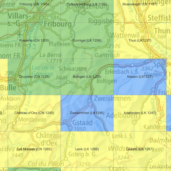
The swissGEOCOVER2D datasets are available according to the 1:25,000 national map grid. The «Division swissGEOCOVER2D» layer shows the perimeter, number and name of each sheet. Clicking on the perimeter of a sheet displays the specific metadata of the dataset (author, status, base used) in the «Object information» window.
Sheets marked as updated, shown in green, have been revised with priority given to adapting the data to the new topography. For each updated dataset, a more detailed report on the performed work is available in the <a href=" https://map.geo.admin.ch/?layers=ch.swisstopo.geologie-geocover&topic=geol" target="_blank">GeoCover - Vector Datasets</a> layer. Sheets marked in yellow are currently being updated or will be updated in the coming years. Finally, the sheets marked in blue will be replaced by new data as soon as the geological surveys are completed (without editorial work in the first instance).
Simple
- Alternate title
-
Division swissGEOCOVER2D
- Date (Creation)
- 2012-01-01
- Date (Revision)
- 2026-05-30
- Identifier
- ch.swisstopo.geologie-geocover.metadata
- Status
- On going
Owner
- Spatial representation type
- Vector
- Topic category
-
- F Geoscientific information
Extent
Extent
- Description
-
Switzerland (extent of the railway network with areas close to the border)
- Geographic identifier
- CH
))

- Maintenance and update frequency
- Continual
- GEMET
-
-
tectonics
-
geomorphology
-
geological process
-
earth science
-
- geocat.ch
-
-
geologic map
-
opendata.swiss
-
FSDI Federal Spatial Data Infrastructure
-
confederation
-
Resource constraints
- Use constraints
- Other restrictions
- Other constraints
- Opendata BY: Open use. Must provide the source.
Associated resource
- Association Type
- Reference to a master resource of which this one is a part
- Metadata Reference
- Language
- Deutsch
- Character encoding
- UTF8
- Language
- Français
- Character encoding
- UTF8
- Language
- Italiano
- Character encoding
- UTF8
- Language
- English
- Character encoding
- UTF8
- Subtopic Category
- F1 Geology
Digital transfer options
- OnLine resource
-
Vorschau map.geo.admin.ch
Preview map.geo.admin.ch
Digital transfer options
- OnLine resource
-
ch.swisstopo.geologie-geocover.metadata
WMS-FSDI service, layer "Division GeoCover"
Digital transfer options
- OnLine resource
-
Produkt- und Bestellinformationen
Digital transfer options
- OnLine resource
-
RESTful API von geo.admin.ch
RESTful API from geo.admin.ch
Identifier
- Code
- EPSG:2056
- Description
-
CH1903+ / LV95 (EPSG:2056)
Metadata
- Metadata identifier
- f7485f4f-2224-4b76-a43c-52cbf8883a42
- Language
- Deutsch
- Character encoding
- UTF8
- Language
- Français
- Character encoding
- UTF8
- Language
- Italiano
- Character encoding
- UTF8
- Language
- English
- Character encoding
- UTF8
- Language
- Rumantsch
- Character encoding
- UTF8
Owner
Type of resource
- Resource scope
- Dataset
- Metadata linkage
-
https://www.geocat.ch/geonetwork/srv/api/records/f7485f4f-2224-4b76-a43c-52cbf8883a42
- Date info (Creation)
- 2014-02-04T13:42:39Z
- Date info (Revision)
- 2026-08-25T13:44:10.817512Z
Metadata standard
- Title
-
eCH-0271