geocat.ch
Blatteinteilung geologische Vektordatensätze GeoCover
Découpage de jeux de données géologiques vectorielles GeoCover
Suddivisione dei fogli dei set di dati geologici vettoriali GeoCover
Division of Geological Vector Datasets GeoCover
Classificaziun da las unitads da datas geologicas vectorialas GeoCover
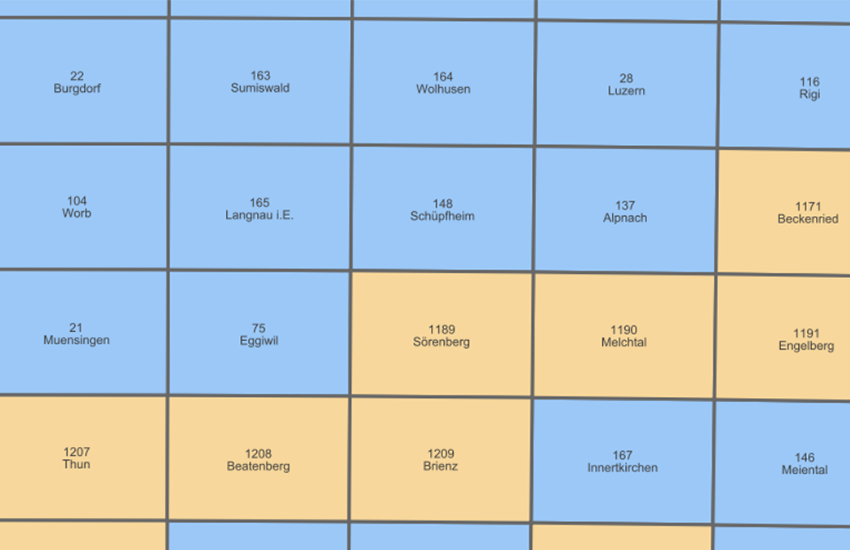
Die GeoCover-Datensätze werden entsprechend der Blatteinteilung der Landeskarte im Massstab 1:25'000 zur Verfügung gestellt. Der Layer «Einteilung GeoCover» zeigt den Perimeter, die Nummer und den Namen jedes Blattes an. Durch Anklicken des Perimeters eines Blattes werden die spezifischen Metadaten des Datensatzes (Autor, Stand, verwendete Basis) in den «Objektinformationen» angezeigt.
Die als aktualisiert gekennzeichneten Blätter, die grün dargestellt sind, wurden überarbeitet, wobei der Schwerpunkt auf der Anpassung der Daten an die neue Topografie lag. Für jeden aktualisierten Datensatz ist im Layer <a href=" https://map.geo.admin.ch/?layers=ch.swisstopo.geologie-geocover&topic=geol" target="_blank">GeoCover - Vektordaten</a> ein kurzer Bericht über die durchgeführten Arbeiten verfügbar. Die gelb markierten Blätter werden derzeit oder in den nächsten Jahren aktualisiert. Die blau markierten Blätter werden durch neue Daten ersetzt, sobald die Erhebungen abgeschlossen sind (vorerst ohne redaktionelle Bearbeitung).
Les jeux de données GeoCover sont mis à disposition selon le découpage de la carte nationale au 1:25'000. La couche «Découpage GeoCover» indique le périmètre, le numéro et le nom de chaque feuille. En cliquant dans le périmètre d’une feuille, les métadonnées spécifiques au jeu de données (auteur, état, base utilisée) apparaissent dans l’«Information Objet».
Les feuilles décrites comme actualisées, symbolisées par une couleur verte, ont été retravaillées avec une priorisation sur l’adaptation des données à la nouvelle topographie. Pour chaque jeu de données actualisé, un rapport un plus détaillé sur les travaux effectués est disponible sur la couche <a href=" https://map.geo.admin.ch/?layers=ch.swisstopo.geologie-geocover&topic=geol" target="_blank">GeoCover - données vectorielles</a>. Les feuilles symbolisées en jaune sont en cours d’actualisation ou le seront ces prochaines années. Finalement les feuilles symbolisées en bleu seront remplacées par des données nouvelles dès que les levés seront terminés (sans travail rédactionnel dans un premier temps).
I set di dati GeoCover sono disponibili secondo la suddivisione del reticolo nazionale in scala 1:25 000. Il livello «Divisione GeoCover» mostra il perimetro, il numero e il nome di ogni foglio. Cliccando sul perimetro di un foglio, i metadati specifici del foglio (autore, stato, banca dati utilizzata) appaiono nelle «Informazioni oggetto».
I fogli descritti come aggiornati, contrassegnati dal colore verde, sono stati rielaborati dando priorità all'adeguamento dei dati alla nuova topografia. Per ogni set di dati aggiornato, è disponibile un rapporto più dettagliato sul lavoro svolto nel livello <a href=" https://map.geo.admin.ch/?layers=ch.swisstopo.geologie-geocover&topic=geol" target="_blank">GeoCover - dati vettoriali</a>. I fogli contrassegnati in giallo sono in fase di aggiornamento o lo saranno nei prossimi anni. Infine, i fogli in blu saranno sostituiti con nuovi dati non appena i rilievi saranno completati (senza lavoro di redazione in una prima fase).
The GeoCover datasets are available according to the 1:25,000 national map grid. The «Division GeoCover» layer shows the perimeter, number and name of each sheet. Clicking on the perimeter of a sheet displays the specific metadata of the dataset (author, status, base used) in the «Object information» window.
Sheets marked as updated, shown in green, have been revised with priority given to adapting the data to the new topography. For each updated dataset, a more detailed report on the performed work is available in the <a href=" https://map.geo.admin.ch/?layers=ch.swisstopo.geologie-geocover&topic=geol" target="_blank">GeoCover - Vector Datasets</a> layer. Sheets marked in yellow are currently being updated or will be updated in the coming years. Finally, the sheets marked in blue will be replaced by new data as soon as the geological surveys are completed (without editorial work in the first instance).
Simple
-
Autre titreAltri nomi o acronimiAlternate titleAlternate titleAlternativtitel
-
Einteilung GeoCover
Découpage GeoCover
Divisione GeoCover
Division GeoCover
Classificaziun GeoCover
-
Date (Dernière révision)Data (Ultima revisione)Date (Last Revision)Date (Last Revision)Datum (Letzte Überprüfung)
- 2022-04-01
-
Date (Révision)Data (Revisione)Date (Revision)Date (Revision)Datum (Aktualisierung)
- 2025-08-27
-
IdentifiantIdentificatoreIdentifierIdentifierKennung
- ch.swisstopo.geologie-geocover.metadata
-
Forme de la présentationForma della presentazionePresentation formPresentation formPräsentationsform
-
Carte numériqueMappa digitaleDigital mapDigital mapDigitale Karte
-
ButScopoPurposePurposeZweck
-
Detailliert Auskunft über den obersten Bereich des Untergrundes der Schweiz
Renseignements détaillés sur les couches supérieures du sous-sol de la Suisse
-
ÉtatStatoStatusStatusBearbeitungsstatus
-
TerminéCompletatoCompletedCompletedAbgeschlossen
Point de contact
Punto di contatto
Point of contact
Point of contact
Ansprechpartner
-
Type de représentation spatialeTipo di rappresentazione spazialeSpatial representation typeSpatial representation typeRäumliche Darstellungsart
-
vecteurVettorialeVectorVectorVektor
Résolution spatiale
Risoluzione spaziale
Spatial resolution
Spatial resolution
Räumliche Auflösung
Fraction représentative
Frazione rappresentativa
Equivalent scale
Equivalent scale
Vergleichsmassstab
-
DénominateurDenominatoreDenominatorDenominatorMassstabszahl
- 25000
-
Catégorie de thèmeCategoria ISOTopic categoryTopic categoryThematik
-
-
F Informations géoscientifiquesF Informazioni geoscientificheF Geoscientific informationF Geoscientific informationF Erdwissenschaften
-
Étendue
Estensione
Extent
Extent
Ausdehnung
Étendue
Estensione
Extent
Extent
Ausdehnung
-
DescriptionDescrizioneDescriptionDescriptionBeschreibung
-
National Map 1:25'000
Landeskarte 1:25'000
Carte nationale 1:25'000
Carta nazionale 1:25'000
-
Identifiant géographiqueIdentificatore geograficoGeographic identifierGeographic identifierGeografische Kennung
- NM25LK25CN25CN25CN25
))

-
Fréquence de mise à jourFrequenza di aggiornamentoMaintenance and update frequencyMaintenance and update frequencyWartungsintervall
-
ContinueContinuaContinualContinualKontinuierlich
- GEMET
-
-
pierre
pietra (edilizia)
stone
-
processus géologique
processi geologici
geological process
-
sédimentation
sedimentazione (geologia)
sedimentation (geology)
-
géomorphologie
geomorfologia
geomorphology
-
tectonique
tettonica
tectonics
-
sciences de la terre
scienze della terra
earth science
-
- GEMET - INSPIRE themes, version 1.0
-
-
Géologie
Geologia
Geology
-
- geocat.ch
-
-
carte géologique
carta geologica
geologic map
-
opendata.swiss
opendata.swiss
opendata.swiss
opendata.swiss
-
- geocat.ch
-
-
BGDI Bundesgeodaten-Infrastruktur
IFDG l’Infrastructure Fédérale de données géographiques
IFDG Infrastruttura federale dei dati geografici
FSDI Federal Spatial Data Infrastructure
-
Contraintes sur la ressource
Vincoli sulle risorse
Resource constraints
Resource constraints
Ressourcenbeschränkungen
-
Autres contraintesAltri vincoliOther constraintsOther constraintsAndere Einschränkungen
-
Freie Nutzung. Quellenangabe ist Pflicht.
Utilisation libre. Obligation d’indiquer la source.
NonCommercialAllowed-CommercialAllowed-ReferenceRequired
Ressource associée
Risorsa associata
Associated resource
Associated resource
Verlinkte Ressource
-
Type d'associationTipo di associazioneAssociation TypeAssociation TypeAssoziationstyp
-
Citation de travail plus largeCitazione di un'opera più ampiaReference to a master resource of which this one is a partReference to a master resource of which this one is a partÜbergeordneter Datenbestand
-
Metadata ReferenceRiferimento metadatiMetadata ReferenceMetadata ReferenceMetadatenreferenz
Ressource associée
Risorsa associata
Associated resource
Associated resource
Verlinkte Ressource
-
TitreTitoloTitleTitleTitel
-
Geologisches Kartenwerk
Cartes géologiques
-
Type d'associationTipo di associazioneAssociation TypeAssociation TypeAssoziationstyp
-
Citation de travail plus largeCitazione di un'opera più ampiaReference to a master resource of which this one is a partReference to a master resource of which this one is a partÜbergeordneter Datenbestand
-
LangueLinguaLanguageLanguageSprache
- Deutsch
-
Encodage de caractèresCodifica dei caratteriCharacter encodingCharacter encodingZeichenkodierung
-
Utf8UTF8UTF8UTF8Utf8
-
LangueLinguaLanguageLanguageSprache
- Français
-
Encodage de caractèresCodifica dei caratteriCharacter encodingCharacter encodingZeichenkodierung
-
Utf8UTF8UTF8UTF8Utf8
-
LangueLinguaLanguageLanguageSprache
- Italiano
-
Encodage de caractèresCodifica dei caratteriCharacter encodingCharacter encodingZeichenkodierung
-
Utf8UTF8UTF8UTF8Utf8
-
LangueLinguaLanguageLanguageSprache
- English
-
Encodage de caractèresCodifica dei caratteriCharacter encodingCharacter encodingZeichenkodierung
-
Utf8UTF8UTF8UTF8Utf8
-
Catégorie de sous-thèmeCategoria di sottotemaSubtopic CategorySubtopic CategoryThematische Unterkategorien
-
F1 GéologieF1 GeologiaF1 GeologyF1 GeologyF1 Geologie
-
Géodonnées de baseGeodati di baseBasic GeodataBasic GeodataGeobasisdaten
- true
-
Identifiant Géodonnées de baseIdentificativo dei geodati di baseBasic Geodata IDBasic Geodata IDIdentifikator des Geobasisdatensatzes
-
-
-
Niveau des géodonnées de baseLivello legale dei geodati di baseBasic Geodata Legal LevelBasic Geodata Legal LevelGeobasisdatenebene
-
FédéralFederaleFederalFederalNational
-
Format de distributionFormato (codifica)Distribution formatDistribution formatAbgabeformat
-
-
ESRI Shapefile (SHP)
-
Options de transfert numérique
Opzioni di trasferimento digitale
Digital transfer options
Digital transfer options
Optionen für die digitale Übertragung
-
Ressource en ligneRisorsa onlineOnLine resourceOnLine resourceOnline
-
Vorschau map.geo.admin.ch
Vorschau map.geo.admin.chAperçu map.geo.admin.chPrevisione map.geo.admin.chPreview map.geo.admin.ch
Options de transfert numérique
Opzioni di trasferimento digitale
Digital transfer options
Digital transfer options
Optionen für die digitale Übertragung
-
Ressource en ligneRisorsa onlineOnLine resourceOnLine resourceOnline
-
ch.swisstopo.geologie-geocover.metadata
WMS-BGDI Dienst, Layer "Einteilung GeoCover"Service WMS-IFDG, couche "Découpage GeoCover"Servizio WMS-IFDG, strato "Divisione GeoCover"WMS-FSDI service, layer "Division GeoCover"WMS-BGDI Dienst, Layer "Einteilung GeoCover"
Options de transfert numérique
Opzioni di trasferimento digitale
Digital transfer options
Digital transfer options
Optionen für die digitale Übertragung
Options de transfert numérique
Opzioni di trasferimento digitale
Digital transfer options
Digital transfer options
Optionen für die digitale Übertragung
-
Ressource en ligneRisorsa onlineOnLine resourceOnLine resourceOnline
-
-
Options de transfert numérique
Opzioni di trasferimento digitale
Digital transfer options
Digital transfer options
Optionen für die digitale Übertragung
-
Ressource en ligneRisorsa onlineOnLine resourceOnLine resourceOnline
-
RESTful API von geo.admin.ch
RESTful API von geo.admin.chRESTful API de geo.admin.chRESTful API da geo.admin.chRESTful API from geo.admin.chRESTful API dad geo.admin.ch
-
Généralités sur la provenanceInformazioni generali sulla provenienzaStatementStatementErklärung
-
Bis der Geologischen Atlas der Schweiz 1:25'000 komplett erstellt und in Papierform verfügbar ist, kann die Qualität der Vektordatensätze entsprechend variieren.
En attendant la rédaction complète de l'Atlas géologique 1:25'000 en format papier, la qualité des jeux de données vectorielles peut ainsi varier.
-
NiveauLivelloHierarchy levelHierarchy levelBezugsebene
-
Jeu de donnéesSet di datiDatasetDatasetDatenbestand
-
Nom du système de référenceNome del sistema di riferimentoReference system identifierReference system identifierName des Referenzsystems
- Referenzsystem entsprechend der zugrundeliegenden topographischen Karte (CH1903)
Metadata
-
Identifiant des métadonnéesIdentificativo della schedaMetadata identifierMetadata identifierIdentifikator des Metadatensatzes
- f7485f4f-2224-4b76-a43c-52cbf8883a42
-
LangueLinguaLanguageLanguageSprache
- Deutsch
-
Encodage de caractèresCodifica dei caratteriCharacter encodingCharacter encodingZeichenkodierung
-
Utf8UTF8UTF8UTF8Utf8
-
LangueLinguaLanguageLanguageSprache
- Français
-
Encodage de caractèresCodifica dei caratteriCharacter encodingCharacter encodingZeichenkodierung
-
Utf8UTF8UTF8UTF8Utf8
-
LangueLinguaLanguageLanguageSprache
- Italiano
-
Encodage de caractèresCodifica dei caratteriCharacter encodingCharacter encodingZeichenkodierung
-
Utf8UTF8UTF8UTF8Utf8
-
LangueLinguaLanguageLanguageSprache
- English
-
Encodage de caractèresCodifica dei caratteriCharacter encodingCharacter encodingZeichenkodierung
-
Utf8UTF8UTF8UTF8Utf8
-
LangueLinguaLanguageLanguageSprache
- Rumantsch
-
Encodage de caractèresCodifica dei caratteriCharacter encodingCharacter encodingZeichenkodierung
-
Utf8UTF8UTF8UTF8Utf8
Point de contact
Punto di contatto
Point of contact
Point of contact
Ansprechpartner
Type de ressource
Tipo di risorsa
Type of resource
Type of resource
Anwendungsbereich der Metadaten
-
Domaine d'application de la ressourceAmbito di applicazione della risorsaResource scopeResource scopeDomäne der Ressourcenanwendung
-
Jeu de donnéesSet di datiDatasetDatasetDatenbestand
-
Lien vers la métadonnéeCollegamento ai metadatiMetadata linkageMetadata linkageLink zu den Metadaten
-
Informations de date (Création)Informazioni sulla data (Creazione)Date info (Creation)Date info (Creation)Datumsangaben (Erstellung)
- 2014-02-04T13:42:39Z
-
Informations de date (Révision)Informazioni sulla data (Revisione)Date info (Revision)Date info (Revision)Datumsangaben (Aktualisierung)
- 2026-04-13T09:25:00.653012Z
Norme des métadonnées
Standard dei metadati
Metadata standard
Metadata standard
Metadatenstandard
-
TitreTitoloTitleTitleTitel
-
eCH-0271