geocat.ch
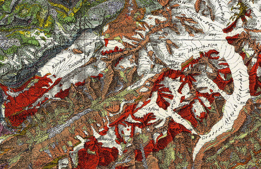
General Geological Map of Switzerland 1:200,000
Geological mapping of the whole country based on the Dufour Map of Switzerland. Comprised of eight sheets, published between 1942 and 1964, the General Geological Map of Switzerland (GGK200) is a historical document of the highest quality. The printed versions of the sheets of the General Geological Map are partially out of print, but each sheet is available as a pixel map.
Simple
- Alternate title
-
General Geol. Map 200
- Date (Creation)
- 1964-12-31
- Date (Last Revision)
- 1965-01-01T00:00:00
- Identifier
- ch.swisstopo.geologie-generalkarte-ggk200
- Presentation form
- Hardcopy map
- Presentation form
- Digital map
- Status
- Completed
Distributor
Point of contact
Owner
- Spatial representation type
- Grid
- Spatial representation type
- paperMap
Spatial resolution
Equivalent scale
- Denominator
- 200000
- Topic category
-
- F Geoscientific information
Extent
Extent
- Description
-
General Geological Map 1:200@squot;000
- Geographic identifier
- GGK200
))

- Maintenance and update frequency
- Not planned
- Duration of Conservation
- 275
- Appraisal of Archival Value
- A
- Reason for Archiving Value
- Evidence of business practice
- geocat.ch
-
-
historic map
-
opendata.swiss
-
geologic map
-
official geodata
-
Conservation and archiving planning AAP - Confederation
-
- GEMET
-
-
earth science
-
sedimentation (geology)
-
stone
-
- geocat.ch
-
-
FSDI Federal Spatial Data Infrastructure
-
Resource constraints
- Other constraints
-
NonCommercialAllowed-CommercialAllowed-ReferenceRequired
Associated resource
- Title
-
Geologisches Kartenwerk
- Association Type
- Reference to a master resource of which this one is a part
- Language
- Deutsch
- Character encoding
- UTF8
- Language
- Français
- Character encoding
- UTF8
- Supplemental Information
-
Einige Karten sind vergriffen, jedoch sind alle im Rasterformat erhältlich.
- Subtopic Category
- F1 Geology
- Basic Geodata
- true
- Basic Geodata ID
-
46.3
- Basic Geodata Legal Level
- Federal
- Distribution format
-
-
GeoTIFF (GEOTIFF)
-
Digital transfer options
- OnLine resource
-
Vorschau map.geo.admin.ch
Preview map.geo.admin.ch
Digital transfer options
- OnLine resource
-
ch.swisstopo.geologie-generalkarte-ggk200
WMS-FSDI service, layer "General Geol. Map 200"
Digital transfer options
- OnLine resource
-
ch.swisstopo.geologie-generalkarte-ggk200
WMTS-FSDI service, layer "General Geol. Map 200"
Digital transfer options
- OnLine resource
-
Produkte- und Bestellinformationen
Digital transfer options
Digital transfer options
- OnLine resource
-
Geologischer Datenviewer
- Statement
-
Auf der Dufourkarte basierendes gesamtschweizerisches geologische Kartenwerk. Die geologische Generalkarte bildet ein historisches Werk höchster Qualität.
- Hierarchy level
- Dataset
- Reference system identifier
- Referenzsystem entsprechend der zugrundeliegenden topographischen Karte (CH1903)
Metadata
- Metadata identifier
- f6416e51-bf55-445a-946e-3eee2134d131
- Language
- Deutsch
- Character encoding
- UTF8
- Language
- Français
- Character encoding
- UTF8
- Language
- Italiano
- Character encoding
- UTF8
- Language
- English
- Character encoding
- UTF8
- Language
- Rumantsch
- Character encoding
- UTF8
Point of contact
Type of resource
- Resource scope
- Dataset
- Metadata linkage
-
https://www.geocat.ch/geonetwork/srv/api/records/f6416e51-bf55-445a-946e-3eee2134d131
- Date info (Creation)
- 2007-12-20T12:00:00Z
- Date info (Revision)
- 2026-04-13T09:48:14.57691Z
Metadata standard
- Title
-
eCH-0271