geocat.ch
Luftbilder Dritte
Images aériennes tiers
Immagini aeree terzi
Aerial images third parties
Fotografias ord l'aria da persunas privatas
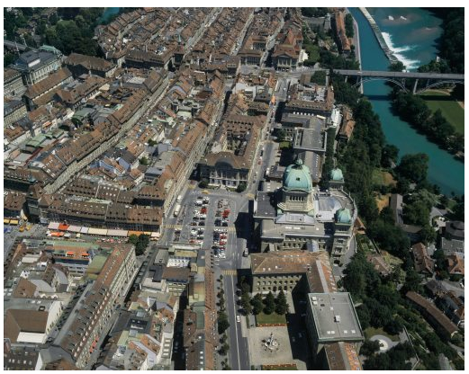
Im Rahmen unterschiedlicher Projekte von öffentlichen und privaten Kunden werden durch Dritte Luftbilder von der Schweiz erhoben und angeboten. Diese Luftbilder können swisstopo gemeldet werden und werden im Layer «Luftbilder Dritte» publiziert. Der Layer beinhaltet ausschliesslich die an swisstopo gelieferten Informationen und erhebt keinen Anspruch auf Vollständigkeit.
Sämtliche Luftbilder werden in Form der Bildzentrumskoordinaten und des vom Luftbild abgedeckten Bodensegmentes sowie mit Metainformationen dargestellt. Die Luftbilder können bei den jeweiligen Stellen bestellt oder bezogen werden.
Dans le cadre de différents projets de clients privés et publics, des images aériennes de la Suisse sont saisies et publiées par des tiers. L’existence de ces images aériennes peut être communiquée à swisstopo. Elles sont alors publiées dans la couche "images aériennes de tiers". La couche ne contient que les informations fournies à swisstopo et ne prétend pas à l'exhaustivité.
Toutes ces images aériennes sont représentées sous la forme des coordonnées du centre de l'image, de la zone couverte par l'image (footprint) ainsi que par des métadonnées. Les images aériennes peuvent être commandées ou obtenues auprès des organismes respectifs.
Nell'ambito di diversi progetti di clienti pubblici e privati, vengono registrate e offerte da terzi immagini aeree della Svizzera. Queste immagini aeree possono essere segnalate a swisstopo e vengono successivamente pubblicate nel layer "Immagini aeree di terzi". Il layer contiene solo le informazioni fornite a swisstopo e non ha alcuna pretesa di completezza.
Le immagini aeree sono presentate sotto forma di coordinate del centro dell'immagine e del segmento di terreno coperto dell’immagine aerea, oltre che con meta-informazioni. Le immagini aeree possono essere ordinate o ottenute presso i rispettivi uffici.
Within the framework of various projects of public and private clients, aerial images of Switzerland are collected and offered by third parties. These aerial images can be reported to swisstopo and are published in the " Aerial images third parties" layer. The layer contains only the information supplied to swisstopo and makes no claim to completeness.
All aerial photographs are presented in the form of the image centre coordinates and the ground segment covered by the aerial image, as well as the attributed meta-information. The aerial images can be ordered or obtained from the respective third party.
En il rom da differents projects da clientella publica e privata fan differentas firmas privatas fotografias ord l'aria da la Svizra. Tut las fotografias ord l'aria vegnan preschentadas en furma da las coordinatas dal center dal maletg, dal segment da terren respectiv sco er cun metainfurmaziuns. Las fotografias ord l'aria pon vegnir empustadas tar las firmas privatas respectivas.
Simple
-
Autre titreAltri nomi o acronimiAlternate titleAlternate titleAlternativtitel
-
Luftbilder Dritte
Images aériennes tiers
Immagini aeree terzi
Aerial images third parties
Fotografias ord l'aria privats
-
Date (Création)Data (Creazione)Date (Creation)Date (Creation)Datum (Erstellung)
- 1927-01-01
-
IdentifiantIdentificatoreIdentifierIdentifierKennung
- ch.swisstopo.lubis-luftbilder-dritte-firmen
Point de contact
Punto di contatto
Point of contact
Point of contact
Ansprechpartner
-
Type de représentation spatialeTipo di rappresentazione spazialeSpatial representation typeSpatial representation typeRäumliche Darstellungsart
-
grilleRasterGridGridRaster, Gitter
-
Catégorie de thèmeCategoria ISOTopic categoryTopic categoryThematik
-
-
A Imagerie, cartes de base et occupation du solA Mappe di base con immagini della copertura terrestreA Imagery base maps earth coverA Imagery base maps earth coverA Oberflächenbeschreibung
-
Étendue
Estensione
Extent
Extent
Ausdehnung
Étendue
Estensione
Extent
Extent
Ausdehnung
-
DescriptionDescrizioneDescriptionDescriptionBeschreibung
-
Switzerland
Schweiz
Suisse
Svizzera
Svizra
))

-
Fréquence de mise à jourFrequenza di aggiornamentoMaintenance and update frequencyMaintenance and update frequencyWartungsintervall
-
InconnueSconosciutoUnknownUnknownUnbekannt
- GEMET
-
-
photographie aérienne
fotografia aerea (immagine)
aerial photograph
-
photographie aérienne
fotografia aerea (immagine)
aerial photograph
-
secteur privé
settore privato
private sector
-
partenariat public / privé
compartecipazione pubblica-privata
public-private partnership
-
- GEMET - INSPIRE themes, version 1.0
-
-
Ortho-imagerie
Orto immagini
Orthoimagery
-
- geocat.ch
-
-
BGDI Bundesgeodaten-Infrastruktur
IFDG l’Infrastructure Fédérale de données géographiques
IFDG Infrastruttura federale dei dati geografici
FSDI Federal Spatial Data Infrastructure
-
Contraintes sur la ressource
Vincoli sulle risorse
Resource constraints
Resource constraints
Ressourcenbeschränkungen
-
Limitation d'utilisationLimitazione d'usoUse limitationUse limitationNutzungsbeschränkung
-
Gebührenpflichtig
Payant
Subject to fee
Ressource associée
Risorsa associata
Associated resource
Associated resource
Verlinkte Ressource
-
Type d'associationTipo di associazioneAssociation TypeAssociation TypeAssoziationstyp
-
Citation de travail plus largeCitazione di un'opera più ampiaReference to a master resource of which this one is a partReference to a master resource of which this one is a partÜbergeordneter Datenbestand
-
Metadata ReferenceRiferimento metadatiMetadata ReferenceMetadata ReferenceMetadatenreferenz
Ressource associée
Risorsa associata
Associated resource
Associated resource
Verlinkte Ressource
-
TitreTitoloTitleTitleTitel
-
Digitale Luftbilder / Flugaufnahmen
Photographies aériennes numériques
Digital aerial photographs
-
Type d'associationTipo di associazioneAssociation TypeAssociation TypeAssoziationstyp
-
Citation de travail plus largeCitazione di un'opera più ampiaReference to a master resource of which this one is a partReference to a master resource of which this one is a partÜbergeordneter Datenbestand
-
LangueLinguaLanguageLanguageSprache
- Deutsch
-
Encodage de caractèresCodifica dei caratteriCharacter encodingCharacter encodingZeichenkodierung
-
Utf8UTF8UTF8UTF8Utf8
-
Catégorie de sous-thèmeCategoria di sottotemaSubtopic CategorySubtopic CategoryThematische Unterkategorien
-
A3 Images aériennes, satellitesA3 Immagini aeree e satellitariA3 Aerial and Satellite ImageryA3 Aerial and Satellite ImageryA3 Luft-, Satellitenbilder
-
Format de distributionFormato (codifica)Distribution formatDistribution formatAbgabeformat
-
-
nan
-
Options de transfert numérique
Opzioni di trasferimento digitale
Digital transfer options
Digital transfer options
Optionen für die digitale Übertragung
-
Ressource en ligneRisorsa onlineOnLine resourceOnLine resourceOnline
-
Vorschau map.geo.admin.ch
Vorschau map.geo.admin.chAperçu map.geo.admin.chPrevisione map.geo.admin.chPreview map.geo.admin.ch
Options de transfert numérique
Opzioni di trasferimento digitale
Digital transfer options
Digital transfer options
Optionen für die digitale Übertragung
-
Ressource en ligneRisorsa onlineOnLine resourceOnLine resourceOnline
-
ch.swisstopo.lubis-luftbilder-dritte-firmen
WMS-BGDI Dienst, Layer "Luftbilder Dritte"Service WMS-IFDG, couche "Images aériennes tiers"Servizio WMS-IFDG, strato "Immagini aeree terzi"WMS-FSDI service, layer "Aerial images third parties"WMS-BGDI Dienst, Layer "Luftbilder Dritte"
Options de transfert numérique
Opzioni di trasferimento digitale
Digital transfer options
Digital transfer options
Optionen für die digitale Übertragung
-
Ressource en ligneRisorsa onlineOnLine resourceOnLine resourceOnline
-
ch.swisstopo.lubis-luftbilder-dritte-firmen
WMTS-BGDI Dienst, Layer "Luftbilder Dritte"Service WMTS-IFDG, couche , Layer "Images aériennes tiers"Servizio WMTS-IFDG, strato "Immagini aeree terzi"WMTS-FSDI service, layer "Aerial images third parties"WMTS-BGDI Dienst, Layer "Luftbilder Dritte"
Options de transfert numérique
Opzioni di trasferimento digitale
Digital transfer options
Digital transfer options
Optionen für die digitale Übertragung
-
Ressource en ligneRisorsa onlineOnLine resourceOnLine resourceOnline
-
RESTful API von geo.admin.ch
Options de transfert numérique
Opzioni di trasferimento digitale
Digital transfer options
Digital transfer options
Optionen für die digitale Übertragung
Metadata
-
Identifiant des métadonnéesIdentificativo della schedaMetadata identifierMetadata identifierIdentifikator des Metadatensatzes
- f614decc-a4f2-480f-b007-b8d9b99bdde5
-
LangueLinguaLanguageLanguageSprache
- Deutsch
-
Encodage de caractèresCodifica dei caratteriCharacter encodingCharacter encodingZeichenkodierung
-
Utf8UTF8UTF8UTF8Utf8
-
LangueLinguaLanguageLanguageSprache
- Français
-
Encodage de caractèresCodifica dei caratteriCharacter encodingCharacter encodingZeichenkodierung
-
Utf8UTF8UTF8UTF8Utf8
-
LangueLinguaLanguageLanguageSprache
- Italiano
-
Encodage de caractèresCodifica dei caratteriCharacter encodingCharacter encodingZeichenkodierung
-
Utf8UTF8UTF8UTF8Utf8
-
LangueLinguaLanguageLanguageSprache
- English
-
Encodage de caractèresCodifica dei caratteriCharacter encodingCharacter encodingZeichenkodierung
-
Utf8UTF8UTF8UTF8Utf8
-
LangueLinguaLanguageLanguageSprache
- Rumantsch
-
Encodage de caractèresCodifica dei caratteriCharacter encodingCharacter encodingZeichenkodierung
-
Utf8UTF8UTF8UTF8Utf8
Point de contact
Punto di contatto
Point of contact
Point of contact
Ansprechpartner
-
Heures de serviceOrario di servizioHours of serviceHours of serviceBetriebszeiten
-
08h30 - 11h00 / 14h00 - 16h00 GMT+1
Type de ressource
Tipo di risorsa
Type of resource
Type of resource
Anwendungsbereich der Metadaten
-
Domaine d'application de la ressourceAmbito di applicazione della risorsaResource scopeResource scopeDomäne der Ressourcenanwendung
-
Jeu de donnéesSet di datiDatasetDatasetDatenbestand
-
Lien vers la métadonnéeCollegamento ai metadatiMetadata linkageMetadata linkageLink zu den Metadaten
-
Informations de date (Création)Informazioni sulla data (Creazione)Date info (Creation)Date info (Creation)Datumsangaben (Erstellung)
- 2013-01-24T15:24:58Z
-
Informations de date (Révision)Informazioni sulla data (Revisione)Date info (Revision)Date info (Revision)Datumsangaben (Aktualisierung)
- 2026-04-13T09:34:25.208772Z
Norme des métadonnées
Standard dei metadati
Metadata standard
Metadata standard
Metadatenstandard
-
TitreTitoloTitleTitleTitel
-
eCH-0271