 geocat.ch
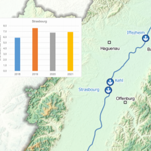
Evolution of port transhipment by waterway on the Upper Rhine
This map shows the evolution of the volume of transhipped goods per port on the Upper Rhine between 2018 and 2021. This document was produced in collaboration with the Central Commission for Navigation on the Rhine (CCNR).
Simple
- Date (Creation)
- 2022-10-25
- Date (Publication)
- 2023-02-09
- Identifier
- 06_2022_290
- Status
- Completed
Point of contact
- mri:deliveryPoint
-
100, avenue d'Alsace
- mri:city
-
COLMAR
- mri:postalCode
-
68000
- Country
-
FRANCE
- mri:electronicMailAddress
-
GeoRhena
Point of contact
- mri:deliveryPoint
-
Palais du Rhin - 2, place de la République
- mri:city
-
STRASBOURG
- mri:postalCode
-
67000
- Country
-
FRANCE
- mri:electronicMailAddress
Spatial resolution
Equivalent scale
- Denominator
- 1000
- Topic category
-
- P Transportation
Extent
Extent
Temporal extent
- Time period
- 2018-01-01 2021-12-31
Extent
Extent
N
S
E
W
))
- Maintenance and update frequency
- Not planned
- Keywords
-
-
Map
-
- Place
-
-
Upper Rhine
-
- GEMET - Concepts, version 2.4
-
-
transportation
-
freight transport
-
river
-
inland navigation
-
Resource constraints
- Use limitation
-
Licence CC BY - ©Central Commission for the Navigation of the Rhine
Resource constraints
- Access constraints
- Other restrictions
- Use constraints
- Other restrictions
- Other constraints
-
No other limitation
- Language
- Français
- Character encoding
- UTF8
- Distribution format
-
-
PDF Map
-
Digital transfer options
- OnLine resource
-
Pdf Download
Digital transfer options
- OnLine resource
-
Volume of goods transported by port and its evolution
Metadata
- Metadata identifier
- f4276c65-48a2-48dc-bc3d-1dbd484dcc20
- Language
- Français
- Character encoding
- UTF8
- Language
- Deutsch
- Character encoding
- UTF8
- Language
- English
- Character encoding
- UTF8
Contact
- mdb:deliveryPoint
-
100, avenue d'Alsace
- mdb:city
-
COLMAR
- mdb:postalCode
-
68000
- mdb:country
-
FR
Type of resource
- Resource scope
- staticMap
- Name
-
Dataset
- Date info (Revision)
- 2023-02-13T08:57:28.64996Z
Metadata standard
- Title
-
ISO 19115-3:2018
- Edition
-
1.0
)))